Newtown Creek
On a map, Newtown Creek looks like a crack splitting the border between Brooklyn and Queens -- a crooked, 3.5-mile tidal channel that empties into the East River near Long Island City. What the map cannot show is the creek's smell, which on a warm day carries the signature of more than a century of industrial abuse: petroleum, sewage, and the chemical residue of processes most New Yorkers have never thought about. Designated a federal Superfund site in 2010, Newtown Creek holds an estimated 30 million gallons of spilled oil beneath its banks, making it one of the most polluted waterways in the United States. And yet, people are fighting to bring it back.
Before the Refineries
The creek takes its name from New Town -- Nieuwe Stad to the Dutch who settled what is now Elmhurst, Queens. Before industrialization reshaped the shoreline, it was a longer, shallower tidal waterway, wide enough to contain small islands like Mussel Island and Furman Island. It drained neighborhoods on both sides: Bushwick, Williamsburg, and Greenpoint in Brooklyn; Maspeth, Ridgewood, Sunnyside, and Long Island City in Queens. During the American Revolution, British General Warren headquartered along its banks. DeWitt Clinton planned portions of the Erie Canal from the Sackett House nearby. A local variety of apple, the Newtown Pippin, grew so fine on Gershom Moore's estate that it won the praise of Benjamin Franklin, Thomas Jefferson, and Queen Victoria, who revoked Britain's import tax on apples after tasting one.
The Petroleum Kingdom
Farmers once barged their goods down the creek to market. Then Pennsylvania oil arrived, and the creek's banks transformed into something unrecognizable. Refineries proliferated -- among them Robert Chesebrough's operation, which processed petroleum jelly and marketed it as Vaseline. By the 1880s, John D. Rockefeller had made Newtown Creek the base of Standard Oil's operations, buying out rival refineries until the company was processing three million gallons of crude weekly and employing 2,000 workers across more than a hundred stills. The pastoral shore became, in one historian's phrase, "a vast interconnected complex of wharves, stills, tanks, and pipelines." Related industries followed: paint and varnish manufacturers, chemical companies producing sulfuric acid. Together, they generated an estimated 300,000 gallons of waste material each week, most of which was burned off or dumped directly into the water and air.
A Wound That Won't Close
The environmental damage accumulated over decades. The Greenpoint oil spill -- one of the largest in American history -- left a subterranean plume of petroleum stretching beneath the neighborhoods along the creek's banks. Combined sewer overflow pipes drain into all four of the creek's major tributaries, meaning that during rainstorms, raw sewage floods directly into the waterway. Because the surrounding neighborhoods are completely connected to the sewer system, the creek receives almost no natural freshwater inflow and sits largely stagnant except when tides push through. In 2007, residents and the New York State Attorney General filed lawsuits over the oil spill. Three years later, the EPA designated the entire creek a Superfund site, beginning the long process of evaluation and cleanup. Investigators expected to find not only petroleum but arsenic, caesium-137, and polychlorinated biphenyls in the sediment.
Signs of Stubborn Life
Against all odds, the creek is not dead. Environmental advocacy groups and the Newtown Creek Alliance have pushed for public access, water-quality monitoring, and restoration. Plank Road Public Shoreline, a revitalized access point in Queens where 58th Road meets the creek, opened in 2013 with a native pollinator garden, mulched pathways, and a plaque detailing the site's significance. From this vantage point, Manhattan is visible across the water -- a jarring reminder that one of the world's most famous skylines sits just miles from one of its most neglected waterways. The Newtown Creek Wastewater Treatment Plant, the largest in New York City, has been expanded, though even modest rainfall can still overwhelm the system. The creek remains a work in progress, its future caught between the city's ambitions for development and the hard reality of what a century of dumping leaves behind.
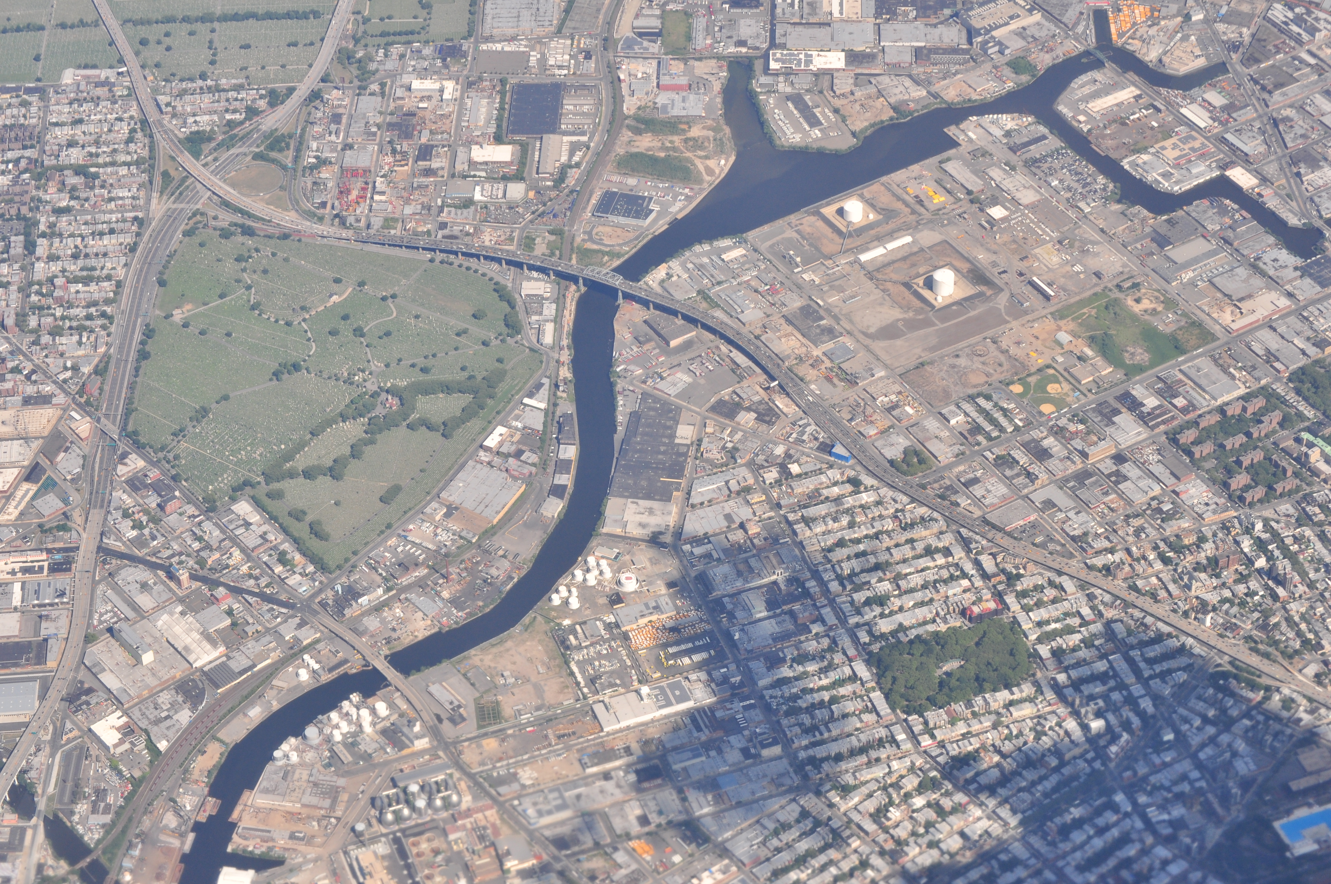
From the Air
Newtown Creek is visible from altitude as the winding waterway forming the Brooklyn-Queens border, emptying into the East River near Long Island City. Coordinates: 40.730N, 73.938W. Look for the distinctive industrial shoreline and the large circular digestor eggs of the Newtown Creek Wastewater Treatment Plant. Nearby airports: KJFK (JFK, 10nm SE), KLGA (LaGuardia, 5nm NE). Best viewed at 2,000-3,000 ft AGL to trace the full creek and its tributaries.