Neys Provincial Park
In 1924, painter Lawren Harris stood on the Coldwell Peninsula and put Pic Island on canvas, producing one of the Group of Seven's most iconic images of the Canadian Shield. Decades earlier, eight crewmen from a wrecked whaleback barge had staggered across that same island in December cold, desperate to reach the mainland. And between those two moments, the ground beneath Harris's feet was already a billion years old -- the exposed core of a collapsed volcano, now one of the rarest mineral complexes in North America. Neys Provincial Park, on the north shore of Lake Superior just west of Marathon, Ontario, holds more stories per square kilometer than most places hold in a century.
A Billion Years Under Your Boots
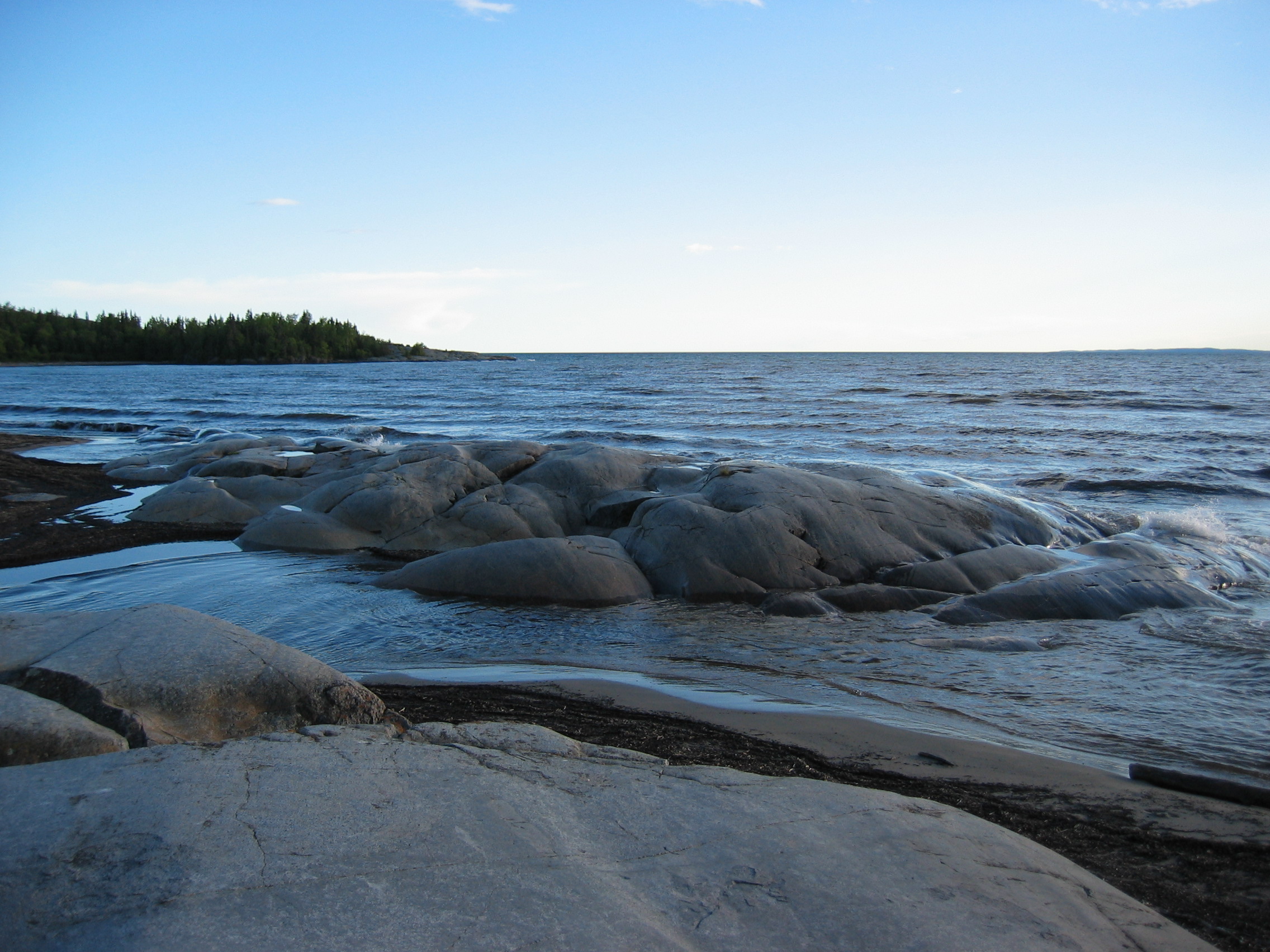
The Coldwell Complex began forming over a billion years ago, when magma chambers swelled beneath the Earth's surface and eventually broke through as an active volcano. Six hundred million years ago, the volcano's own walls grew so massive they collapsed inward, plugging the vent and trapping magma in the chamber below. There it cooled and crystallized with other minerals over hundreds of millions of years. Then, roughly 10,000 years ago, retreating glaciers stripped away the top layers of the extinct volcano like peeling back the lid of a furnace. What remains today is the magma chamber itself, exposed as surface rock along the northern shore of Lake Superior. A 2.5-kilometer trail lets hikers walk across what was once the molten heart of a mountain. The Coldwell Complex is one of the hardest and rarest mineral formations on the continent.
Where the Arctic Clings to the Shore
Lake Superior's frigid waters create a microclimate along Neys' rocky shores that is cooler, windier, and moister than the surrounding boreal forest -- conditions that support plant species normally found hundreds of kilometers further north. Butterwort, three-toothed cinquefoil, crowberry, and bird's-eye primrose grow in cracks and crevices where thin soil has accumulated on wave-washed rock, forming what botanists call an Arctic disjunct community: a pocket of subarctic vegetation isolated far from its main geographic range. Lichens coat the bare rock, and the herbs survive conditions that would kill most plants in the adjacent forest. Inland from the shore, the Central Boreal Forest takes over, dense with spruce, larch, and Labrador tea. A rare herd of woodland caribou roams through the park, alongside moose and black bears. The park's beach is considered one of the finest on Lake Superior's north shore.
Camp 100: Barbed Wire on the Shield
During World War II, Canada interned 35,046 prisoners of war and Japanese-Canadians across 26 camps. Three of those camps sat on the north shore of Lake Superior: Neys, Angler, and Red Rock. Neys Camp 100 operated between 1941 and 1946, holding mostly German POWs along with some Japanese-Canadians. The prisoners were put to work logging in the Pic and Little Pic River valleys. German prisoners were classified as either "greys" -- ordinary soldiers -- or "blacks," die-hard Nazis considered high risks for violence or escape. Neys was one of nine Canadian camps that held black prisoners, and it was enclosed by three barbed-wire fences and guard towers. Escape attempts were almost unheard of. In summer, dense forests and relentless blackflies formed a natural barrier. In winter, sub-zero temperatures and Lake Superior's vast, frigid expanse made the idea suicidal. After the war, the camp briefly served as a POW processing center, then a minimum-security civilian work camp, before being dismantled in the 1950s. A plantation of Red Pine now grows where the camp once stood, likely planted by Boy Scouts in the 1960s as part of their national Centennial Project.
The Ghost of Coldwell
Just outside the park's eastern boundary lies what remains of Coldwell, a railway and fishing community that thrived until the 1960s. Lumberjacks arrived each fall via the Canadian Pacific Railway, traveling upriver to logging camps where they spent the winter felling trees and stacking cordwood. Come spring thaw, they rode the logs down the river on drives, using peaveys to guide timber to boom logs chained at the river's mouth. Tugboats hauled the log rafts to the Slate Islands, where steamers carried them south to American mills. In 1943 alone, POWs from Camp 100 cut 90,000 of the 98,000 cords of wood harvested by the Pigeon Timber Company. But the world changed. Steam engines gave way to diesel, the Trans-Canada Highway bypassed the old rail communities, and the federal government ordered all Canadian timber processed domestically. Marathon Pulp and Paper built a mill and a town on the railway, and trucks replaced river drives. Coldwell emptied out. Today, a few foundations, some shipwrecks in the harbor, and a cemetery are all that mark where a village once stood.
Trails Through Time
Neys offers 144 campsites and a trail network that reads like a timeline of the park's layered past. The Dune Trail winds through sand dunes and past a beaver pond. The Point Trail follows the Lake Superior shore to a rocky outcropping where boats that once ferried POW lumberjacks still rest beached on the rock. The Under the Volcano Trail extends along the coast with interpretive stops explaining the billion-year geological story of the Coldwell Complex. The Tower Trek Trail, a 10.5-kilometer round trip taking about four and a half hours, climbs to a vantage point overlooking Pic Island -- the same island Lawren Harris painted in 1924, the same island where the crew of Barge 115 sheltered in December 1899. Two day-use areas carry names that echo the park's dual identity: Prisoner's Cove and The Little Pic.
From the Air
Neys Provincial Park (48.75N, -86.583W) occupies the Coldwell Peninsula on Lake Superior's north shore. Pic Island is the prominent landmass visible offshore to the south-southwest. Approach from the south at 3,000-5,000 feet AGL for the best perspective on the peninsula, the island system, and the contrast between the boreal forest and the rocky shore. Marathon Airport (CYSP) is approximately 15 km east. Highway 17 (Trans-Canada) runs along the park's northern boundary. The Little Pic River is visible entering the lake at the park's western edge.