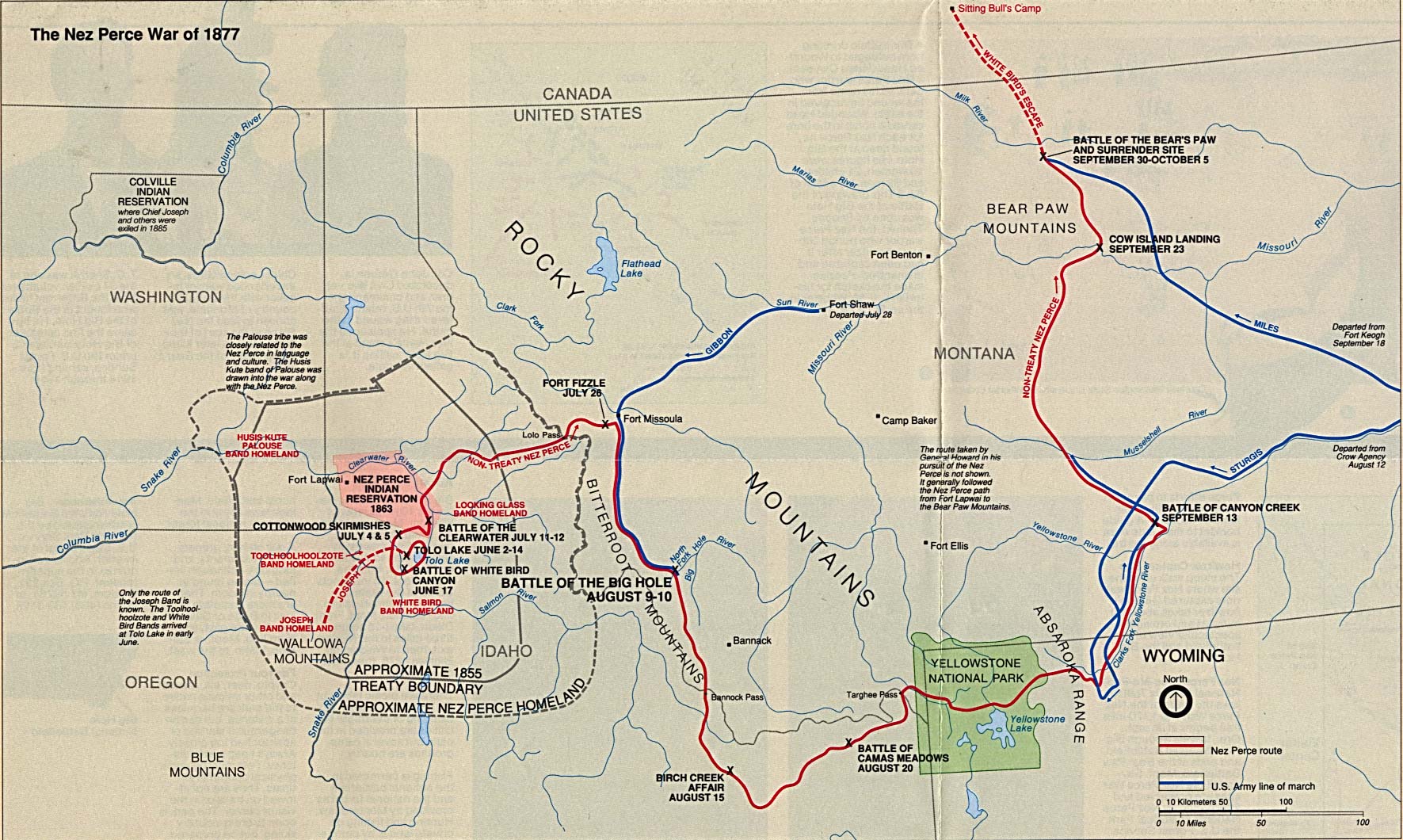
Nez Perce Flight Through Yellowstone
General William Tecumseh Sherman had been vacationing in Yellowstone just days before. His scout assured a group of tourists from Radersburg, Montana, that they would be "perfectly safe" from the Nez Perce. Emma Cowan, one of those tourists, noted drily that Sherman's party "preferred being elsewhere, as they left...that same night." She was about to learn why. Between August 20 and September 7, 1877, approximately 750 Nez Perce men, women, and children fled through Yellowstone National Park - America's first national park, barely five years old - while the U.S. Army tried to trap them at every exit.
Refugees in the Wilderness
The Nez Perce who entered Yellowstone were not invaders but refugees. Since June 1877, they had resisted relocation from their ancestral lands on Oregon's Wallowa River to a reservation in Idaho. By late August, they had traveled hundreds of miles across Idaho and Montana, fighting several battles in which they defeated or held off pursuing Army forces. Their leader, Chief Joseph, had become something of a national hero in the press - a "military genius" leading his people in a desperate bid for freedom. After fighting to a bloody draw at the Battle of the Big Hole on August 9 and raiding the Army's camp at Camas Creek on August 20, they headed east into the geothermal wilderness of Yellowstone, hoping to cross the plateau and reach Crow territory in Montana.
Tourists Caught in the Crossfire
When the Nez Perce entered Yellowstone, eight or nine parties of tourists - at least 35 people - were exploring the park's wonders. On August 24, Yellow Wolf's scouting party encountered the Radersburg tourists camped near the Lower Geyser Basin. The Nez Perce forced the group to accompany them toward their main camp. Around noon, upon advice from guide Poker Joe, the chiefs released the tourists - but on condition they surrender all horses and supplies. Thirty minutes later, stragglers intercepted the departing tourists. George Cowan was shot point-blank in the head; Albert Oldham took a painful face wound. Remarkably, both survived. Chief Joseph himself gave protection to Emma Cowan and her siblings before releasing them with two horses. Another tourist party from Helena fared worse: Charles Kenck was shot dead, and Richard Dietrich was killed days later when he unwittingly took refuge in a building the fleeing Nez Perce passed.
Sherman's Trap
While General Howard rested his exhausted troops at Henrys Lake, his superior Sherman was constructing a trap. Lieutenant Gustavus Doane with 100 men guarded the north entrance at Mammoth Hot Springs. Colonel Samuel Sturgis with 360 men covered Clark's Fork to the east. Major Hart positioned 250 cavalry and 100 scouts at the Shoshone River exit. Colonel Wesley Merritt waited to the south on the Wind River with 500 men. Colonel Nelson Miles stood ready at Fort Keogh in Montana. Over 1,200 soldiers surrounded Yellowstone, waiting for 750 refugees - mostly women, children, and elderly - to emerge. The Nez Perce had three possible escape routes, and the Army believed it had covered them all.
The Canyon Nobody Could Pass
The Nez Perce chose Clark's Fork - the route Colonel Sturgis had dismissed, believing "no trail could possibly lead through it." The lower miles of Clark's Fork passed through a narrow canyon with vertical walls 800 feet high. Sturgis considered it impassable. The Nez Perce knew better. They sent scouts to feint toward the Shoshone River, drawing Sturgis away from his position. Then they threaded through the "impossible" canyon and emerged onto the Montana plains unopposed. By the time Sturgis realized his error and linked up with Howard on September 11, the two Army forces were two days and 50 miles behind the Nez Perce. Sherman's elaborate trap had failed completely.
Names Written on the Land
Today, Yellowstone bears witness to this desperate flight. Nez Perce Creek, officially named in 1885, marks the east fork of the Firehole River. Nez Perce Ford commemorates where Chief Joseph's people crossed the Yellowstone River on August 25, 1877. Joseph Peak rises in the Gallatin Range, named by surveyors in 1885 to honor Chief Joseph's passage. Cowan Creek memorializes George Cowan, the tourist who survived a bullet to the head. The Chief Joseph Scenic Byway (Wyoming Highway 296) follows part of the route through Sunlight Creek, Dead Indian Hill, and Dead Indian Campground - names that echo with the tragedy of a people who fought for freedom and found only heartbreak. The Nez Perce would continue north into Montana, only to be captured just 40 miles from the Canadian border.
From the Air
Located at 44.66N, 111.10W near Yellowstone's west entrance. The Nez Perce route crosses the park from west to northeast - visible landmarks include the Lower Geyser Basin, Mary Mountain trail, the Yellowstone River crossing (Nez Perce Ford), and the dramatic Clark's Fork canyon to the northeast. Joseph Peak (10,494 ft) stands in the Gallatin Range. Nearest airports include West Yellowstone (KWYS, 10nm west) and Yellowstone Regional (KCOD, 55nm east near Cody). Best viewed at 8,000-10,000 feet MSL to see the full route. The Clark's Fork canyon is particularly dramatic from the air, revealing how the Nez Perce escaped through terrain the Army considered impassable.