Nindowari
Two hundred and forty kilometres northwest of Karachi, on the right bank of the Kud River where it feeds into the Porali, a low mound rises from the Balochistan scrubland. This is Nindowari, also known as Nindo Damb, an archaeological site that bridges two of South Asia's earliest civilizations. Excavations here have revealed layers of Harappan occupation overlaid by the Kulli culture, a prehistoric society whose bull-seal motifs and terracotta figurines suggest a deep connection with the great cities of the Indus Valley, yet whose regional identity remained stubbornly distinct.
At the Edge of the Indus World
The Indus Valley Civilization, which flourished from roughly 3300 to 1300 BC across what is now Pakistan and northwest India, is best known through its great urban centers: Mohenjo-daro, Harappa, Rakhigarhi. But its influence extended far beyond those planned cities. Nindowari sits in the Khuzdar District of Balochistan, well west of the Indus floodplain, in a landscape of dry hills and seasonal watercourses. The site dates to the Chalcolithic period, the Copper Age, when metalworking was transforming human societies across South and Central Asia. What archaeologists found here suggests that the Harappans reached this far-flung corner, and that the culture that succeeded them carried forward recognizable traditions.
The Kulli Connection
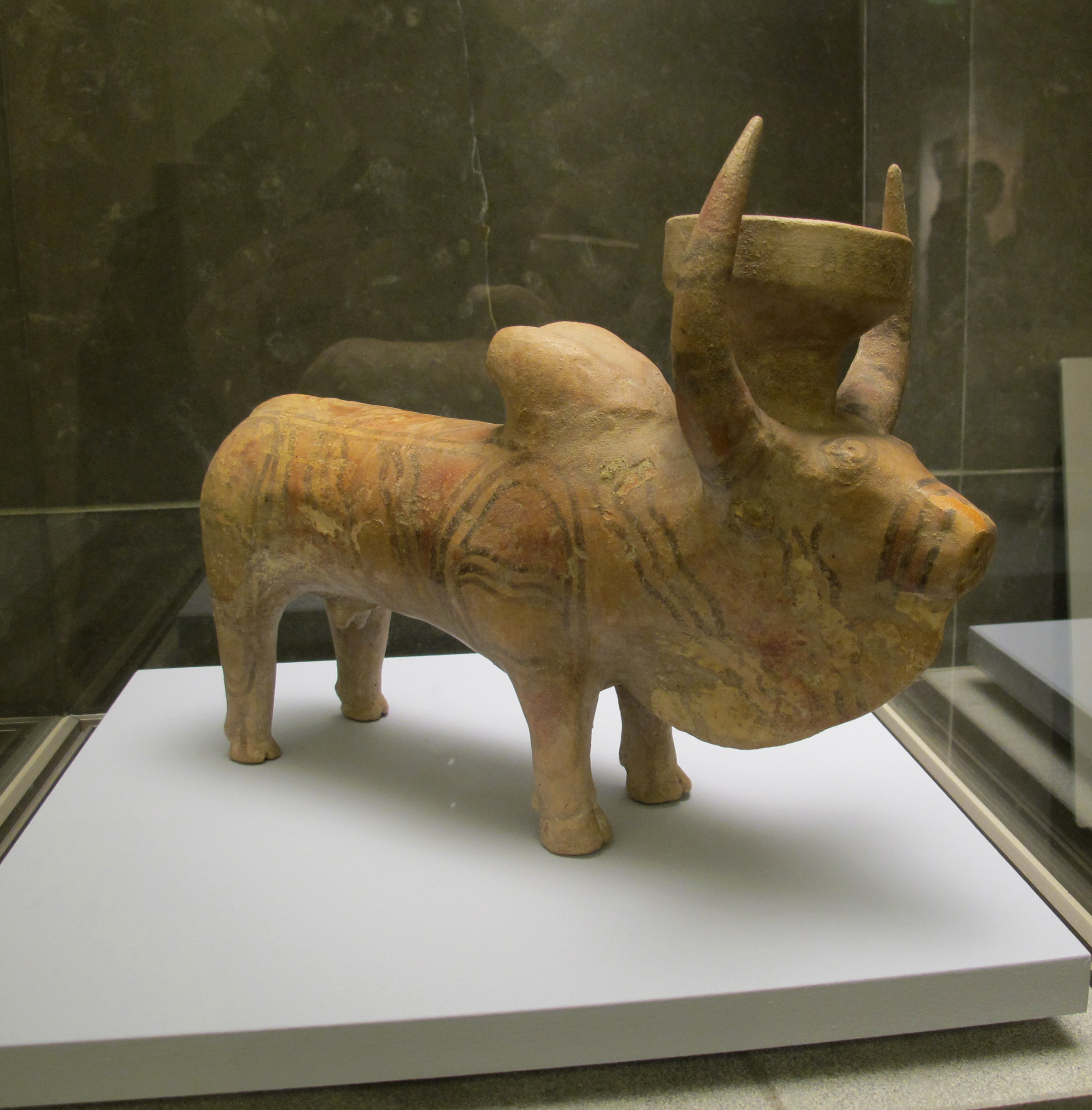
The Kulli culture is named after a type site in Balochistan and is distinguished by its painted pottery, terracotta figurines, and distinctive bull iconography. At Nindowari, terracotta figurines bearing drawings of bulls -- strikingly similar to the famous seals of Harappa and Mohenjo-daro -- confirmed that the site was once occupied by Harappan peoples. The subsequent Kulli occupation may represent a regional variant or offshoot of the broader Harappan civilization, reflecting cultural continuity across what could have been a significant time span. The relationship between the two cultures remains a subject of scholarly debate: were the Kulli people a separate society that absorbed Harappan influences, or were they simply the Harappan periphery adapting to local conditions?
River, Trade, and Distance
Nindowari's location on the Kud River, a tributary of the Porali, placed it along a natural corridor connecting the interior of Balochistan with the Arabian Sea coast. This positioning was likely no accident. The Indus civilizations were trading societies, and sites along navigable waterways served as links in networks that moved goods between highland producers and coastal ports. Nearby sites like Sohr Damb, also in Khuzdar District, show overlapping cultural layers from the same era, suggesting that this corner of Balochistan supported a chain of settlements connected by river and footpath. The landscape itself -- arid, rocky, cut by seasonal floods -- has changed little since the Chalcolithic, making the terrain visible from the air today much the same as what those early settlers would have navigated on foot.
A Mound With Questions
Nindowari has yielded its secrets slowly. The source material is thin compared to the major Indus sites, and much remains unexcavated. What has been found -- pottery, figurines, evidence of occupation layers -- raises more questions than it answers about the exact nature of the Harappan-Kulli transition in western Balochistan. Was this a colony? A trading post? An independent settlement that adopted motifs from a more powerful neighbor? The mound sits quietly on the riverbank, surrounded by the same dry hills that enclosed it five thousand years ago, holding answers that will require further excavation to recover.
From the Air
Nindowari is located at approximately 27.00N, 66.50E in Khuzdar District, Balochistan province. The site is a low archaeological mound on the right bank of the Kud River, a tributary of the Porali River. From altitude, the terrain is arid and hilly with sparse vegetation. The nearest airport is in Khuzdar. The landscape is characterized by dry valleys, seasonal watercourses, and rocky ridges typical of central Balochistan. Best viewed at lower altitudes (5,000-8,000 feet) to distinguish the mound from surrounding terrain.