Nippur
No army ever marched from Nippur to conquer a rival city. No dynasty rose from its streets to dominate Mesopotamia. Yet for more than three thousand years, from the earliest Sumerian kings to the Assyrian emperors, control of this city mattered more than almost any military victory. Nippur was the seat of Enlil, the "Lord Wind," ruler of the cosmos in the Sumerian pantheon. To hold Nippur was to hold divine sanction. To lose it was to lose the right to rule. The city's power was not political but theological, and that made it more durable than any empire.
The City That Made Kings
Nippur's importance was inseparable from its great temple, the Ekur, "Mountain House," dedicated to Enlil. According to the Tummal Chronicle, Enmebaragesi, an early ruler of Kish, was the first to build up the temple. The chronicle reads like a who's who of Sumerian legend: Aga of Kish, Mesannepada of Ur, Gilgamesh of Uruk -- all maintained ceremonies at the Ekur, because doing so conferred legitimacy. Later rulers designated themselves as ensis, governors, on their votive offerings at Nippur, acknowledging that their authority derived from the god who lived there. Even the conquerors of Akkad -- Sargon, Rimush, Naram-Sin -- made offerings at the Ekur after subduing the city, recognizing that military power alone was not enough.
Rebuilt by Every Empire
The archaeological layers at Nippur read like a compressed history of civilization. Ur-Nammu of the Third Dynasty of Ur gave the temple its definitive form around 2100 BCE, erecting a ziggurat of three stages in dry brick faced with kiln-fired bricks laid in bitumen, oriented with its corners toward the cardinal points. Hammurabi shifted political and religious authority to Babylon in the 18th century BCE, and Enlil's attributes were gradually transferred to Marduk. But Nippur refused to become irrelevant. The Kassites restored it. The Assyrians rebuilt it. Even after Alexander the Great's conquests, a Hellenistic settlement grew on the site. Occupation continued through the Parthian and Sasanian periods, and a small Jewish community persisted there into the Islamic era. The city adapted, layer upon layer, like a palimpsest written in mud brick.
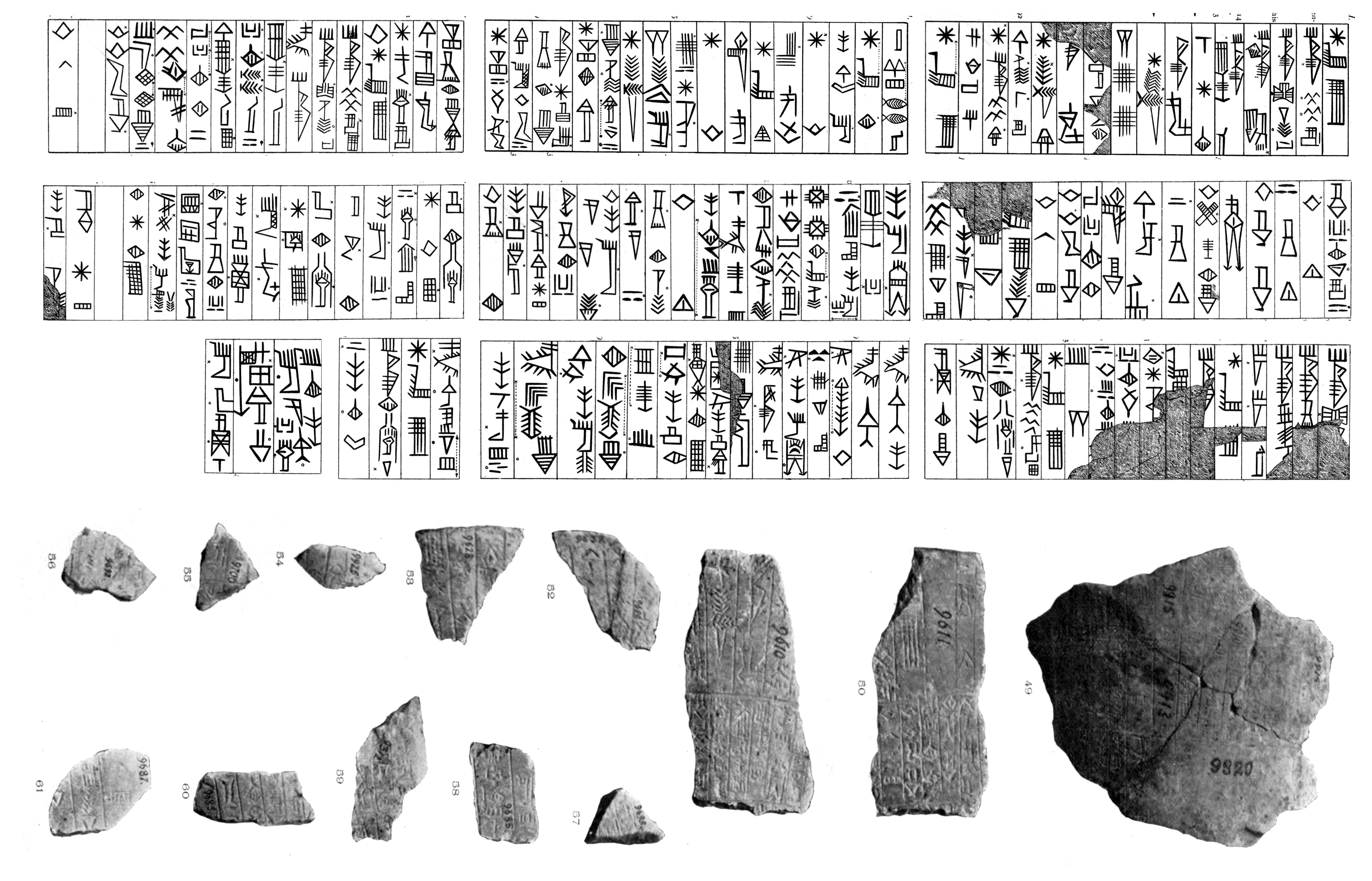
Tablet Hill
Nippur's most remarkable legacy may be literary. A smaller mound southeast of the main temple complex, dubbed "Tablet Hill" by excavators, yielded thousands of cuneiform tablets. Among them was a significant portion of the known Sumerian literary corpus, including hymns, myths, and administrative records spanning millennia. The site also produced a clay map -- one of the world's oldest known city plans -- showing the quarter east of the Shatt-en-Nil canal, with its walls, storehouses, and the temple compound carefully drawn. This was a city that recorded itself obsessively, and those records survived because the medium was baked clay, impervious to the rot that consumed papyrus and parchment elsewhere.
Digging Through the Centuries
Sir Austen Henry Layard visited briefly in 1851. The first major excavation came between 1889 and 1900, when a University of Pennsylvania expedition led by John Punnett Peters, John Henry Haynes, and Hermann Volrath Hilprecht dug through the mounds the Arabs called Nuffar. They found the highest point of the ruins, a conical hill rising about 30 meters above the surrounding plain, which locals called Bint el-Amir, "prince's daughter." A true arch -- one of the world's earliest known examples -- emerged from the dig. The Oriental Institute of Chicago returned for 19 seasons between 1948 and 1990, peeling back layers that ranged from Ubaid-period pottery to Parthian glass. At its maximum extent, the site covered 130 hectares, a sprawling complex divided by the dry bed of the ancient Shatt-en-Nil canal into east and west mounds.
A Sacred Crossroads
Nippur sat roughly 200 kilometers south of modern Baghdad and about 100 kilometers southeast of ancient Babylon, positioned where the Shatt-en-Nil canal -- one of the earliest courses of the Euphrates -- once flowed. Nearby Drehem, sometimes called a suburb of Nippur, served as a massive livestock redistribution center during the Ur III period, channeling cattle, sheep, and goats from across the state to the temples. The sacred city was also a commercial hub, fed by the agricultural surplus of southern Mesopotamia. Today the mounds stand in the flat landscape of Al-Qadisiyyah Governorate, 8 kilometers north of modern Afak, quiet testimony to a time when this patch of Iraqi earth was the spiritual center of the known world.
From the Air
Located at 32.13N, 45.23E in Al-Qadisiyyah Governorate, Iraq, roughly 200 km south of Baghdad and 100 km southeast of ancient Babylon. The site appears as a large complex of ruin mounds (known locally as Nuffar) in flat alluvial plain, divided by the dry bed of the Shatt-en-Nil canal. The highest mound (Bint el-Amir) rises about 30 meters above the plain. Maximum site extent was 130 hectares. Nearest airports include Al Najaf International Airport (ORNI) and Baghdad International Airport (ORBI). Best viewed at 3,000-5,000 feet to see the full layout of mounds and the ancient canal bed.