Nooitgedacht Glacial Pavements
The name means "never thought of" in Afrikaans, and that captures something essential about Nooitgedacht. This unassuming stretch of bedrock between Kimberley and Barkly West holds three hundred million years of Earth's history pressed into a single surface you can touch with your hands. Glaciers from the Dwyka Ice Age polished the andesite smooth when southern Africa sat near the South Pole. San and Khoe artists pecked eland and rhinoceros into that same rock within the last fifteen hundred years. And between 1949 and 1981, diamond diggers sifted eighty thousand gems from the gravels covering it. Three vastly different chapters of history, written on one piece of ground.
When Africa Wore Ice
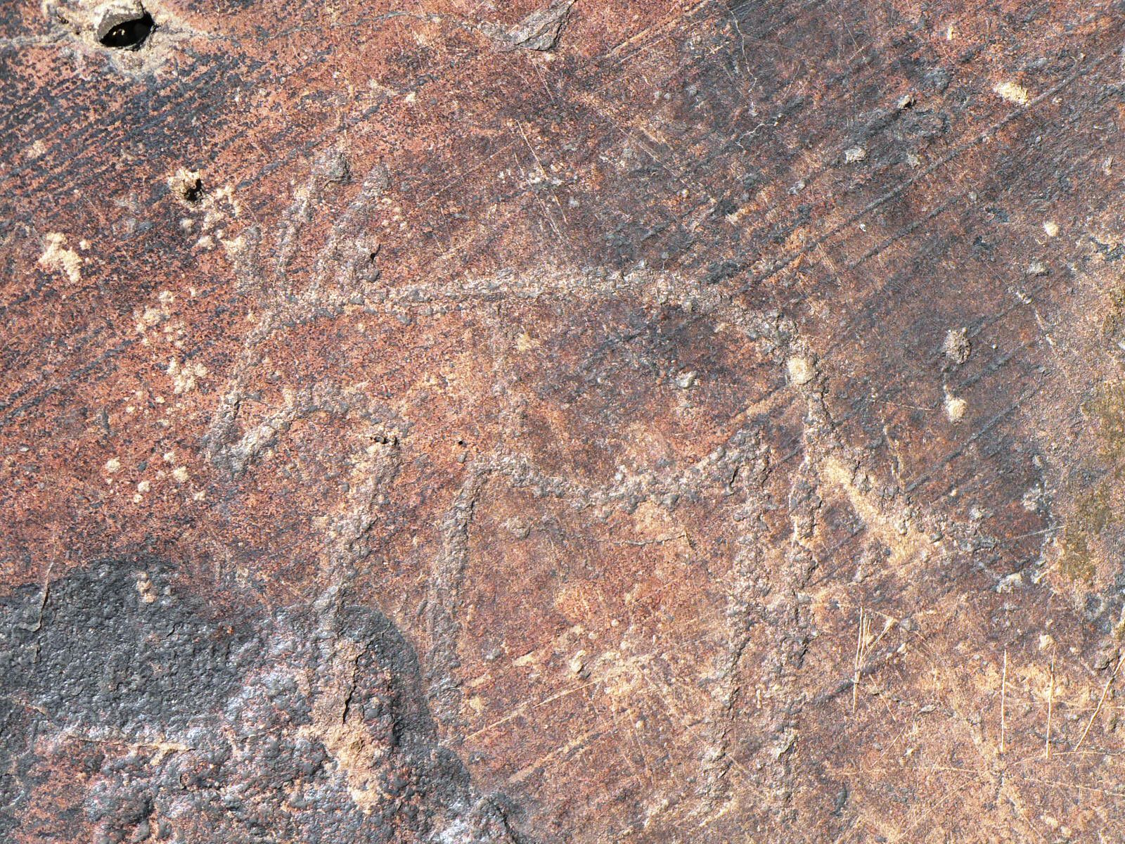
Three hundred million years ago, plate tectonics had pushed what is now southern Africa to the bottom of the world. Glaciers blanketed the high-lying Cargonian Highlands, a terrain stretching from the modern Northern Cape through Gauteng to Mpumalanga. As the Dwyka glaciers ground southward, rocks and rubble embedded in their undersides abraded the volcanic andesite bedrock beneath, scouring it smooth and carving parallel striations into its surface like fingernail scratches on clay. These marks survive at Nooitgedacht today, precise enough for geologists to determine which direction the ice moved.
As the supercontinent Gondwanaland drifted northward, the glaciers melted. They left behind a slurry of clay and boulders that compressed into tillite, the foundation layer of the entire Karoo rock sequence. Erratics carried hundreds of kilometers by the ice still sit on the pavements at Nooitgedacht, stranded reminders of a journey that ended when the world warmed.
Diamonds in the Dust
The Vaal River, flowing just beside Nooitgedacht, has spent millions of years stripping away a kilometer-thick blanket of Karoo sediment. That erosion re-exposed the 2.7-billion-year-old andesite bedrock shaped by the Dwyka glaciers, and it also freed something far more valuable. Between 120 and 90 million years ago, kimberlite pipes had punched through the Earth's crust in this region, carrying diamonds from deep within the mantle. As the Karoo rock above eroded away, diamonds washed into river gravels and waited.
Since 1869, prospectors have worked the Vaal's alluvial deposits intensively. The Nooitgedacht diggings opened in 1949 with claims measuring just fifteen by fifteen meters. Miners washed the diamond-bearing gravel by hand in rotary pans, then sorted through the heavy concentrate grain by grain. Over thirty-two years, they recovered eighty thousand stones. The largest was the Venter Diamond, a yellow gem weighing 511 carats. The diggings closed in 1981, reopened in the late 1990s, and small-scale miners still work the riverbanks with picks and shovels, though heavy equipment has largely taken over.
Marks That Outlast Empires
Centuries before diamond seekers arrived, the glacial pavements served a different purpose. Ancestors of the San and Khoe people used the smooth andesite surfaces as canvases, pecking out images with pointed stones. No metal tools, no chisels. The engravings depict eland, rhinoceros, ostrich, giraffe, and human figures alongside geometric patterns that may represent bags, aprons, or abstract spiritual concepts.
Scholars debate what these images mean and who made them. One interpretation links the geometric-heavy sites like Nooitgedacht and nearby Driekops Eiland to a Khoekhoe herder tradition, distinct from the animal-rich engravings at places like Wildebeest Kuil, which appear more typically San. Another perspective suggests the geometric motifs may relate to girls' coming-of-age ceremonies practiced by both San and Khoekhoe communities. Either way, the engravings span roughly the last fifteen hundred years, placing them in the Later Stone Age of the late Holocene. The artists chose surfaces that glaciers had prepared three hundred million years earlier, unknowingly connecting the deepest of geological time to living human culture.
The Diamond Fields Dispute
When diamonds surfaced along the Vaal in 1869 and 1870, they triggered a territorial scramble. On 18 August 1870, the presidents of the Orange Free State and Transvaal republics met at Nooitgedacht with Griqua Chief Nicolaas Waterboer and his agent David Arnot to settle who owned the diamond-bearing land. The negotiations collapsed when the Griqua delegation walked out. The Free State promptly claimed the territory.
But the dispute was not finished. The British government intervened through the Keate Award, which ruled in Waterboer's favor. Waterboer placed himself under British protection, and on 27 October 1871 the Crown Colony of Griqualand West was proclaimed. This political realignment, driven by the glitter of alluvial diamonds, reshaped the map of southern Africa and foreshadowed the mineral-driven conflicts that would define the region for the next century.
A Monument in the Karoo
The site was declared a National Monument in 1936, recognizing the extraordinary convergence of geological, archaeological, and historical significance concentrated in this one location. Under South Africa's National Heritage Resources Act of 1999, Nooitgedacht is now classified as a Grade 2 Provincial Heritage Site. But heritage status has not insulated it from the pressures of ongoing mining. Heavy earth-moving equipment has replaced the hand shovels and rotary pans of the mid-twentieth century, and the environmental impact on both the landscape and the rock art it preserves is substantial.
Standing at Nooitgedacht, the layers of time are almost vertiginous. The volcanic rock beneath your feet formed 2.7 billion years ago. Glaciers shaped it 300 million years ago. Artists engraved it within the last millennium. Diamond seekers tore through its gravels within living memory. Few places on Earth compress so many chapters of planetary and human history into a single, walkable landscape.
From the Air
Located at 28.60S, 24.61E, between Kimberley and Barkly West in the Northern Cape, South Africa. The site sits adjacent to the Vaal River, which is visible as a dark winding line through the semi-arid Karoo landscape. Nearest airport is Kimberley Airport (FAKM), approximately 30 km to the southeast. Barkly West lies about 10 km to the northeast. At cruising altitude, the area appears as flat, dry scrubland with the Vaal River corridor cutting through it. Old mine workings and tailings dumps may be visible near the river. Recommended viewing altitude: 3,000-5,000 feet AGL for best detail of the river and mine workings.