Nordkalottleden
The trail has four names in four languages -- Nordkalottleden in Swedish, Nordkalottruta in Norwegian, Kalottireitti in Finnish, Kalohtamadii in Sami -- which tells you something about the territory it crosses. Established in 1993, this 800-kilometer route winds through the Arctic wilderness of Finnish Lapland, northern Norway, and Swedish Norrland, crossing national borders so frequently that the concept of "which country am I in" becomes almost academic. From Kautokeino on the Finnmark plateau to Sulitjelma in the Norwegian mountains, or alternatively to Kvikkjokk in Sweden, the Nordkalottleden traverses some of the most remote and least populated landscape in Europe.
Through the Sami Homeland
The trail passes through the heart of Sapmi, the traditional homeland of the Sami people. Before motorized vehicles arrived, Fell Sami followed their reindeer herds on seasonal migrations from winter pastures to calving grounds and summer grazing lands. Some families still maintain these movements. Hikers may encounter Sami camps where fresh fish, bread, or local products are sometimes available for purchase. The trail demands a particular etiquette around reindeer: during calving season and herding periods, you sit quietly if a herd approaches and wait for the animals to pass. Splitting a herd creates hours of extra work for the herders who depend on them. The landscape carries its history in its place names -- Sami, Norwegian, Swedish, and Finnish names often coexist for the same features. Sulitelma, Sulitjelma, and Sulidalbma all describe the same mountain. Learning to read a trilingual map becomes part of the journey.
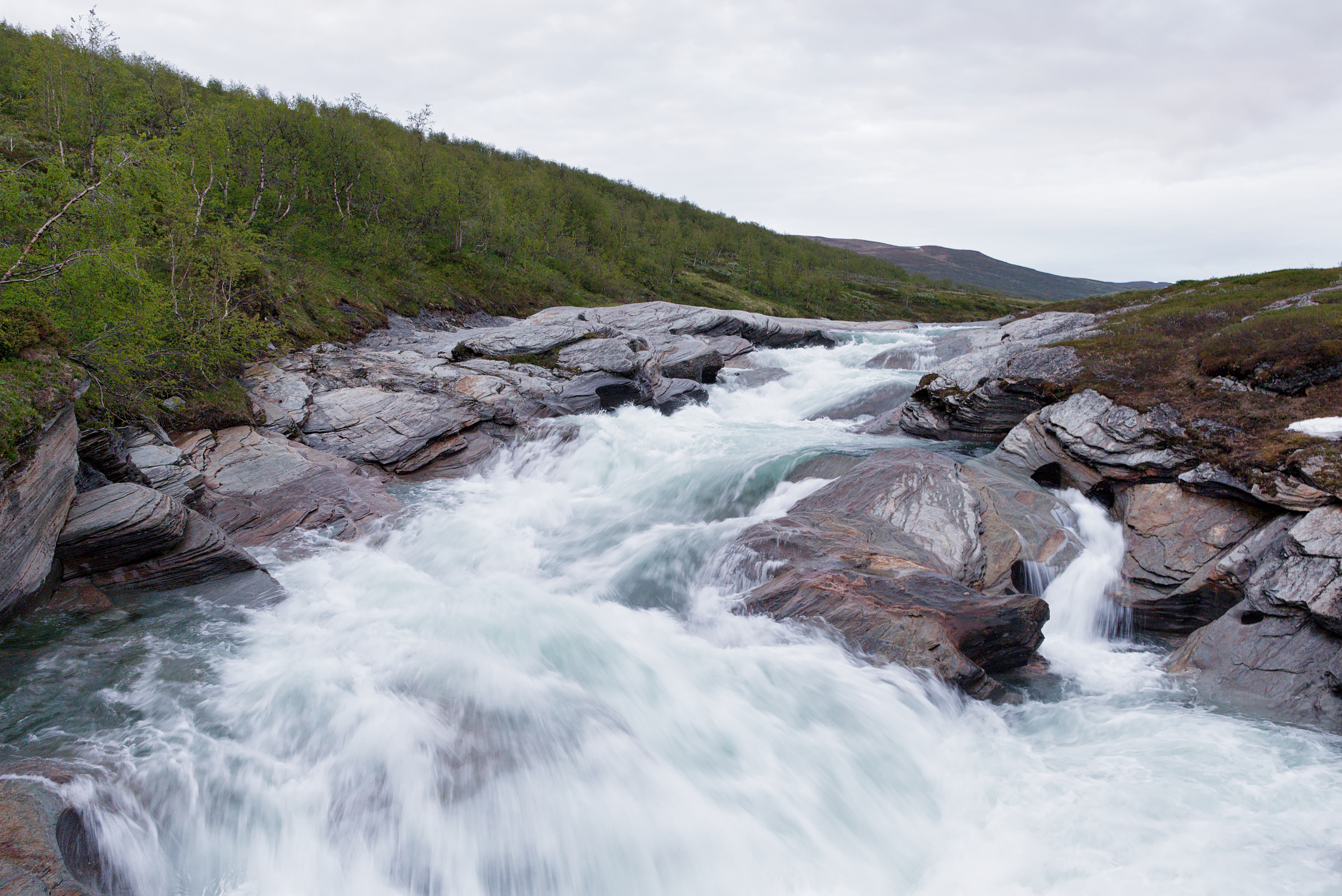
Fell Heath and River Crossings
Most of the route follows open fell heaths and sparse birch forests above the tree line, where the walking is generally straightforward but exposure to wind and weather is constant. Tents must handle severe conditions, because descending to sheltered terrain is often not an option. The trail crosses numerous rivers -- major ones usually by bridge, smaller ones by wading. Some bridges marked as sommarbro on maps are removed after summer, and spring meltwater can turn routine crossings into serious obstacles. The Reisa Valley section offers one of the trail's most dramatic stretches: the path descends from open plateau into a lush river valley where tributaries cascade down hillsides, geological formations line the canyon walls, and the Mollesjohka waterfall drops 269 meters in one of the tallest waterfalls in Northern Europe. Bear, lynx, wolverine, and elk inhabit this country, though encounters are rare.
Huts, Borders, and Self-Sufficiency
A network of huts spaces the trail at intervals ranging from 5 to 50 kilometers, but their character shifts with each border crossing. Finnish huts, maintained by the governmental Metsahallitus, are either reservable or open wilderness shelters -- unstaffed, unprovisioned, with shared platform beds. Norwegian huts, run by local DNT clubs, are locked with a standard key and often feature separate dormitories and solar power. Swedish huts range from simple unlocked shelters to staffed mountain stations with shops and restaurants. Carrying a tent is strongly recommended regardless, since huts can fill during peak season. The trail demands genuine self-sufficiency: most food must be carried, resupply points are scarce and unreliable, and shops exist only at a handful of access villages. Cloudberries, crowberries, and bog bilberries grow wild in season, free for picking in most areas.
Light, Dark, and the Brief Window
The hiking season runs from July to mid-September, a window defined by snow, daylight, and insects. In early summer, deep snowfields and swollen rivers can block the route even into July. By late September, snowfall makes hiking without skis nearly impossible. Between these boundaries, the Arctic rewards those who come prepared. At the trail's northern reaches, the midnight sun lingers until late July, and nights remain bright well into August. By mid-September, true darkness returns -- and with it, the possibility of northern lights. The insects arrive on schedule too: from Midsummer through August, mosquitoes and black flies can be ferocious in valleys and boggy terrain, though wind-exposed ridges offer some relief. Hiking in late August or September usually means fewer bites, cooler temperatures, and the first autumn colors spreading across the fell birch forests.
The Long Walk Between Worlds
Nordkalottleden partly overlaps with Kungsleden, Sweden's most famous hiking trail, and also shares sections with the European long-distance path E1, which runs all the way from Italy. But where Kungsleden concentrates its drama into well-serviced stages, Nordkalottleden sprawls across three nations and many days of genuine solitude. Some sections near popular trailheads or Kungsleden overlaps draw crowds with full huts in peak season. Others offer days without seeing another person. Access points are remote: Kautokeino, Kilpisjarvi, and Abisko have daily bus or train connections and basic shops, but reaching trailheads like Vaisaluokta or Njallajávrre requires boats, long hikes, and advance planning. The trail is marked throughout, though marking quality varies. In fog on the open fells, a compass and downloaded offline maps become necessities rather than luxuries.
From the Air
The Nordkalottleden stretches approximately 800 km through Arctic Scandinavia, roughly between 67°N and 69°N latitude and 16°E to 24°E longitude. The trail passes through terrain ranging from sea level to approximately 1,500 m. Key landmarks visible from the air include Lake Tornetrask near Abisko, the Reisa River valley and canyon, the Finnmark plateau, and the Sulitjelma/Akka mountain massifs. Nearest airports include Kiruna (ESNQ), Tromso (ENTC), and Narvik/Harstad (ENEV). The Abisko area near the trail can be identified by the Iron Ore Line railway running along the north shore of Tornetrask. Mountainous terrain throughout; maintain safe altitude.