North West Highlands Geopark
Three billion years of Earth's history lie exposed across 2,000 square kilometres of Scotland's northwest corner, and it took a bitter Victorian scientific feud to understand what they meant. The North West Highlands Geopark, awarded UNESCO status in 2004 as Scotland's first geopark, stretches from Cape Wrath to the Summer Isles along a largely treeless landscape of Lewisian gneiss, Torridonian sandstone, and Durness limestone. These rocks -- pink, red-brown, and pale grey respectively -- tell a story that begins when the planet was young and continues through ice ages, Norse settlement, and the pioneering geological fieldwork that gave the world the concept of a thrust fault.
The Highlands Controversy
In the 19th century, geologists noticed something puzzling in these hills: older rocks appeared to sit on top of younger ones, defying the basic principle that deeper means older. Roderick Murchison and Archibald Geikie insisted the apparent anomaly could be explained within conventional theory. James Nicol and Charles Lapworth disagreed. The debate -- the so-called "Highlands Controversy" -- was resolved by Ben Peach and John Horne between 1883 and 1897. They proved that an immense sheet of ancient Moine rock had been pushed roughly 70 kilometres eastward over younger formations by tectonic forces, creating the Moine Thrust Belt. It was the first thrust fault ever identified. A monument to Peach and Horne stands within the park, erected in 1930 as an international tribute. The fault itself is most easily seen at Knockan Crag, where a visitor centre and outdoor sculptures mark the spot where geological orthodoxy was overturned.
A Catalogue of Deep Time
The geopark reads like a textbook of rock types arranged across the landscape. Lewisian gneiss, the oldest rock in Britain at around three billion years, forms the undulating basement terrain in shades of pink and grey-green. Torridonian sandstone, roughly a billion years old, builds the dramatic mountains -- Suilven, Stac Pollaidh, Quinag, Foinaven, and Arkle among them. Pale quartzite, some 500 million years old, caps several ridges and contains fossilised worm burrows known as pipe rock. Durness limestone, at 480 million years, underlies the caves and karst landscape of the north coast. At the eastern edge, Moine rocks -- metamorphosed sandstone about 980 million years old -- mark the boundary where the great thrust pushed them westward. Igneous intrusions of granite and syenite punctuate the sequence at various ages.
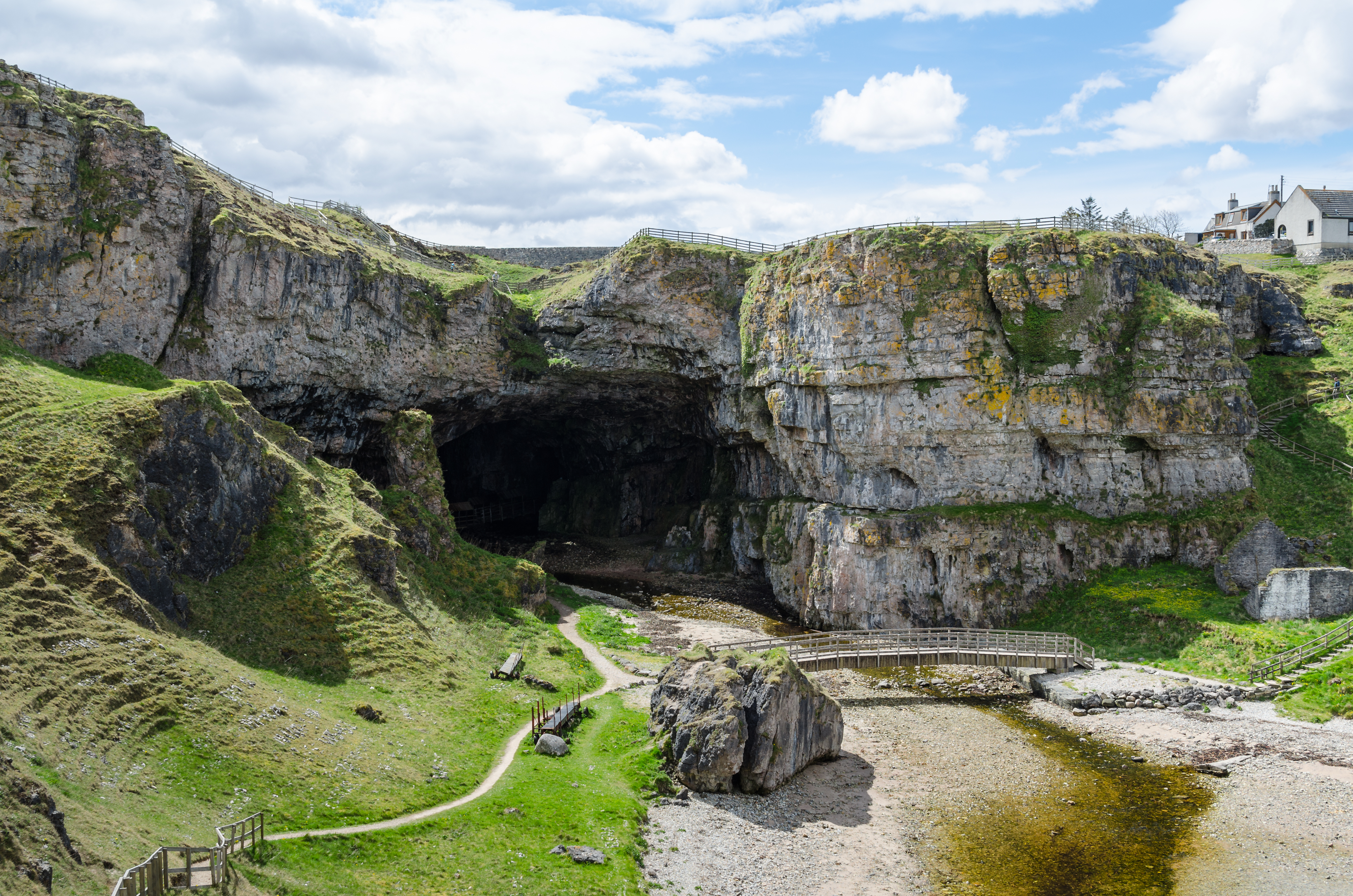
Underground Worlds
The limestone terrain harbours remarkable caves. Smoo Cave near Durness, with its 15-metre-high entrance -- the largest of any sea cave in the British Isles -- is unique in Britain for combining a sea-formed outer chamber with freshwater-carved inner passages. Archaeological excavations found evidence of human habitation stretching back to the Mesolithic period, and Sir Walter Scott's 1814 visit brought it wider fame. Inland, the Inchnadamph Bone Caves have yielded remains of Eurasian lynx, brown bear, Arctic fox, reindeer, and polar bear, along with human bones dated between 4,515 and 4,720 years old. Below these caves lies Uamh an Claonaite, Scotland's longest cave system.
Edge of the Mainland
Cape Wrath, the northwesternmost point on the Scottish mainland, anchors the geopark's most extreme geography. Its cliffs are the highest vertical sea cliffs in mainland Britain. The mountains rising from the gneiss plateau to the south -- Suilven's distinctive sugar-loaf profile chief among them -- appear more like desert inselbergs than typical Highland peaks, their Torridonian sandstone towers standing in dramatic isolation above a landscape scoured by glaciers. It is a terrain that looks like it belongs to another continent entirely, and in geological terms, it once did: the Lewisian gneiss formed part of a landmass that predates the Atlantic Ocean.
From the Air
Located at 58.117N, 5.133W in the Northwest Highlands. The geopark spans roughly 2,000 km2 from Cape Wrath south to Ullapool. Distinctive isolated mountains (Suilven, Stac Pollaidh, Quinag) visible on approach. Knockan Crag visitor centre is near the A835. Nearest airports: Inverness (EGPE) 60 nm southeast, Stornoway (EGPO) 50 nm west across the Minch. Cape Wrath cliffs prominent on the north coast.