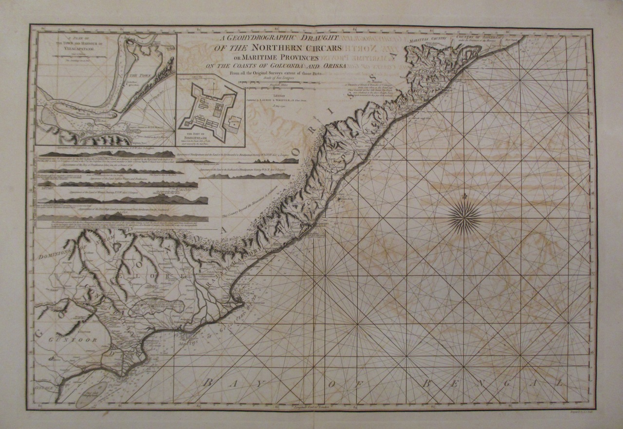
Northern Circars
The word itself is a clue to how many hands have shaped this coast. Circar is an English rendering of sarkar, a Mughal administrative term for district, in use since the time of Sher Shah Suri in the early 1500s. By the time the British finished acquiring the Northern Circars in 1823, the word had picked up an additional meaning: British Sarkar, the government itself. Five districts along the Bay of Bengal, stretching from roughly Guntur in the south to Srikakulam in the north, had passed through so many empires that the language of governance had bent to accommodate them all.
Five Districts, Five Centuries of Contest
The Northern Circars comprised five districts: Chicacole (modern Srikakulam), Rajmandri (Rajahmundry), Ellore (Eluru), Mustaphanagar (Kondapalli), and Murtuzanagar (Guntur). Together they covered approximately 30,000 square miles of coastal territory, a narrow strip running along the western shore of the Bay of Bengal between 15 and 20 degrees north latitude. The region corresponds to the northern and central portions of what is now Coastal Andhra in Andhra Pradesh, spanning more than a dozen modern districts. Parts of present-day Odisha and Telangana also fell within the old Circar boundaries. This was never a unified kingdom but rather a collection of administrative districts whose ownership changed with each new conqueror, from the Bahmani Sultanate in 1471 to the Qutb Shahi dynasty of Golconda to the Mughal emperor Aurangzeb to, finally, the British East India Company.
Conquest Without Armies
What makes the British acquisition of the Northern Circars unusual is how little fighting it involved. The process stretched from 1758 to 1823, a protracted campaign of diplomacy and financial settlements rather than military conquest. The British did not storm the Circars; they negotiated, purchased, and maneuvered their way into control, district by district, over six decades. The consequence for Hyderabad State was devastating. The Nizam's dominion had once possessed a significant coastline through the Circars. Losing them transformed Hyderabad into the landlocked princely state that history remembers, a vast territory in the Central Deccan entirely surrounded by British India. The Nizam retained wealth, ceremonial authority, and an enormous palace, but the sea was gone. For a state that had once controlled trade routes to the Bay of Bengal, it was a quiet catastrophe.
Kingdoms Buried Beneath Borders
Before the British or the Mughals, the Circars saw centuries of contest among regional powers. The Bahmani Sultanate invaded in 1471. The Qutb Shahi dynasty of Golconda conquered the Guntur and Masulipatnam districts beginning in 1541, though their hold was incomplete. The conquest was only finished in 1571 under Ibrahim Quli Qutb Shah. Then Aurangzeb absorbed Golconda into the Mughal Empire in 1687, and the Circars changed hands again. Through all of this, local rulers like the kings of Jeypore maintained degrees of independence until the British arrived in 1777, destroyed the fort at Jeypore, and demoted the royal family to zamindari status. Each new ruler left traces in the land: Mughal administrative terminology, Qutb Shahi architectural fragments, and British-era revenue records that still shape how property is understood along this coast.
From Presidency to State and Back Again
The Northern Circars were governed as part of the Madras Presidency until Indian independence in 1947. The Presidency became Madras State, and in 1953 the northern, Telugu-speaking portion, including the Circars, was detached to form the new Andhra State. Three years later, the Andhra State merged with the Telugu-speaking parts of Hyderabad State to create a united Andhra Pradesh. That unity lasted until 2014, when the state was bifurcated into Andhra Pradesh and Telangana. The Circars, always part of the coastal Telugu-speaking region, remained within Andhra Pradesh. Five centuries of empire had drawn and redrawn the map around these five districts, yet the fundamental geographic reality persisted: a narrow, fertile coastal strip between the Eastern Ghats and the Bay of Bengal, producing rice and cotton, connected to the interior by rivers and to the world by the sea.
From the Air
The Northern Circars region stretches along the Bay of Bengal coast of Andhra Pradesh, centered approximately at 17.45N, 83.00E near Visakhapatnam. From the air, the narrow coastal plain between the Eastern Ghats and the bay is clearly visible. Major cities within the old Circar boundaries include Visakhapatnam, Rajahmundry, Eluru, and Guntur. Visakhapatnam Airport (VOHS) is the primary airport in the region. At higher altitudes, the full extent of the coastal strip from Guntur to Srikakulam becomes apparent, with the Eastern Ghats forming a continuous wall to the west.