Northern Oregon Coast
The first sight of Haystack Rock stops conversation. Rising 235 feet from the surf at Cannon Beach, this volcanic monolith has become Oregon's most photographed landmark - but it's just the opening act on a coastline that delivers drama mile after mile. The Northern Oregon Coast runs from the Columbia River's mouth south through fishing villages, artists' colonies, and some of the most spectacular shoreline in North America. Sea stacks dot the offshore waters like sentinels. Fog rolls through old-growth spruce forests. Tidal pools teem with life at the base of basalt cliffs. And unlike much of the American coastline, every inch of Oregon's beaches is public, a gift from early lawmakers who declared that the shore belongs to everyone.
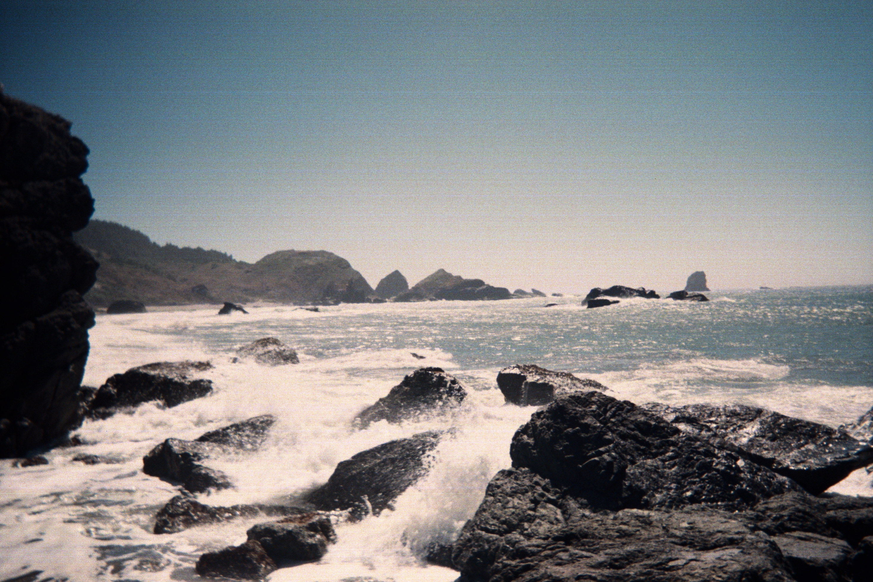
The Cannon Beach Icons
Cannon Beach takes its name from a cannon that washed ashore in 1846 from the wreck of a naval schooner, but today the town is synonymous with Haystack Rock. The massive sea stack rises from the beach at low tide, surrounded by tidepools where purple sea urchins, orange sea stars, and green anemones create underwater gardens. Tufted puffins nest on its summit from spring through summer - one of the most accessible puffin colonies on the Pacific coast.
The town itself is a carefully curated village of galleries, restaurants, and bookshops that somehow avoids feeling precious. Hemlock Street hosts boutiques that would fit in Carmel or Santa Fe. The beach stretches for miles in either direction, walkable at low tide, offering views of smaller sea stacks that punctuate the shore like exclamation points. Sunset here is theatrical - the rock silhouetted against bands of orange and purple, photographers lined up like pilgrims at a shrine.
Astoria and the River's Mouth
Where the Columbia River meets the Pacific, Astoria presides over one of the most dangerous harbor entrances in the world. The 'Graveyard of the Pacific' has claimed over 2,000 ships since records began, their wrecks scattered across the bar where river and ocean collide. Today, the town wears its maritime history proudly - Victorian mansions climb the hillside, the Astoria Column offers 360-degree views from its 125-foot height, and the Columbia River Maritime Museum chronicles centuries of commerce and tragedy.
Astoria was the first permanent American settlement west of the Mississippi, founded by John Jacob Astor's fur trading company in 1811. Lewis and Clark wintered nearby at Fort Clatsop after completing their transcontinental journey. The town that grew up around the river trade has weathered booms and busts - salmon canning, logging, shipping - and emerged as an arts community where galleries occupy former fish processing plants and brewpubs fill historic downtown storefronts.
Headlands and Capes
The Northern Oregon Coast is punctuated by volcanic headlands that jut into the Pacific, each one a natural fortress against the ocean's assault. Cape Disappointment guards the Columbia's north side, its lighthouse warning ships away from the bar. Cape Meares shelters a lighthouse built in 1890 and the Octopus Tree, a Sitka spruce whose branches have grown outward rather than upward, creating an otherworldly canopy.
Tillamook Head rises between Cannon Beach and Seaside, its trails offering views that extend from the mouth of the Columbia to Tillamook Bay. Lewis and Clark hiked here in January 1806, seeking whale blubber from a beached carcass. The path they took is now part of the Oregon Coast Trail, which runs the entire length of the state's coastline - 382 miles of beaches, headlands, and forest traverses that can be done in sections or as a weeks-long through-hike.
Manzanita to Pacific City
South of Cannon Beach, the coast grows quieter. Manzanita hides at the base of Neahkahnie Mountain, a small town of beach houses and a single commercial strip that somehow escaped the tourist development that transformed its neighbors. The mountain's summit offers one of the coast's great hikes - a climb through old-growth forest to views that sweep from Tillamook Head to Cape Lookout.
Tillamook Bay opens a gap in the coastline, its waters famous for the cheese factory that ships cheddar worldwide and the oysters harvested from its tidal flats. Pacific City, at the bay's southern edge, is known for its dory fleet - flat-bottomed boats launched directly through the surf, a fishing tradition dating back generations. Cape Kiwanda's sandstone cliffs offer an accessible alternative to the basalt fortresses elsewhere, their golden rock eroded into caves and arches that glow at sunset.
The Tidal Edge
Low tide on the Oregon coast reveals a hidden world. Rocky platforms emerge from the retreating water, their surfaces covered in mussels and barnacles, their pools harboring creatures that seem to belong to another era. Purple sea urchins cluster in depressions they've carved in the rock over decades. Ochre sea stars - some orange, some purple - drape themselves over mussel beds. Hermit crabs scuttle between hiding spots. Anemones wave tentacles that close tight when touched.
The best tide-pooling requires timing - minus tides expose areas normally submerged, revealing the richest diversity. Haystack Rock's pools are famous, but less-visited spots offer equally rewarding exploration: Yaquina Head, Cape Perpetua's tide pools, the rocky benches at Seal Rock. Oregon law protects these intertidal zones, prohibiting the collection of marine life. Watch, photograph, marvel - but leave everything where you found it, alive and attached.
From the Air
Located along the Oregon coast from 46.2°N (Columbia River mouth) to approximately 44.5°N. The coastline is highly distinctive from altitude - look for the dramatic sea stacks at Cannon Beach, including Haystack Rock (235 ft tall) rising from the surf. The Columbia River mouth is clearly visible at the north end, with Astoria on the south bank. Multiple volcanic headlands (Cape Meares, Cape Lookout, Cape Kiwanda) jut into the Pacific. Tillamook Bay creates a notable indentation in the coastline. The entire coast shows the contrast between dark forested headlands and sandy beaches. Nearest airports: Astoria Regional (KAST), Portland International (KPDX) 80nm east. Marine layer and fog are common, especially summer mornings; conditions often clear by afternoon.