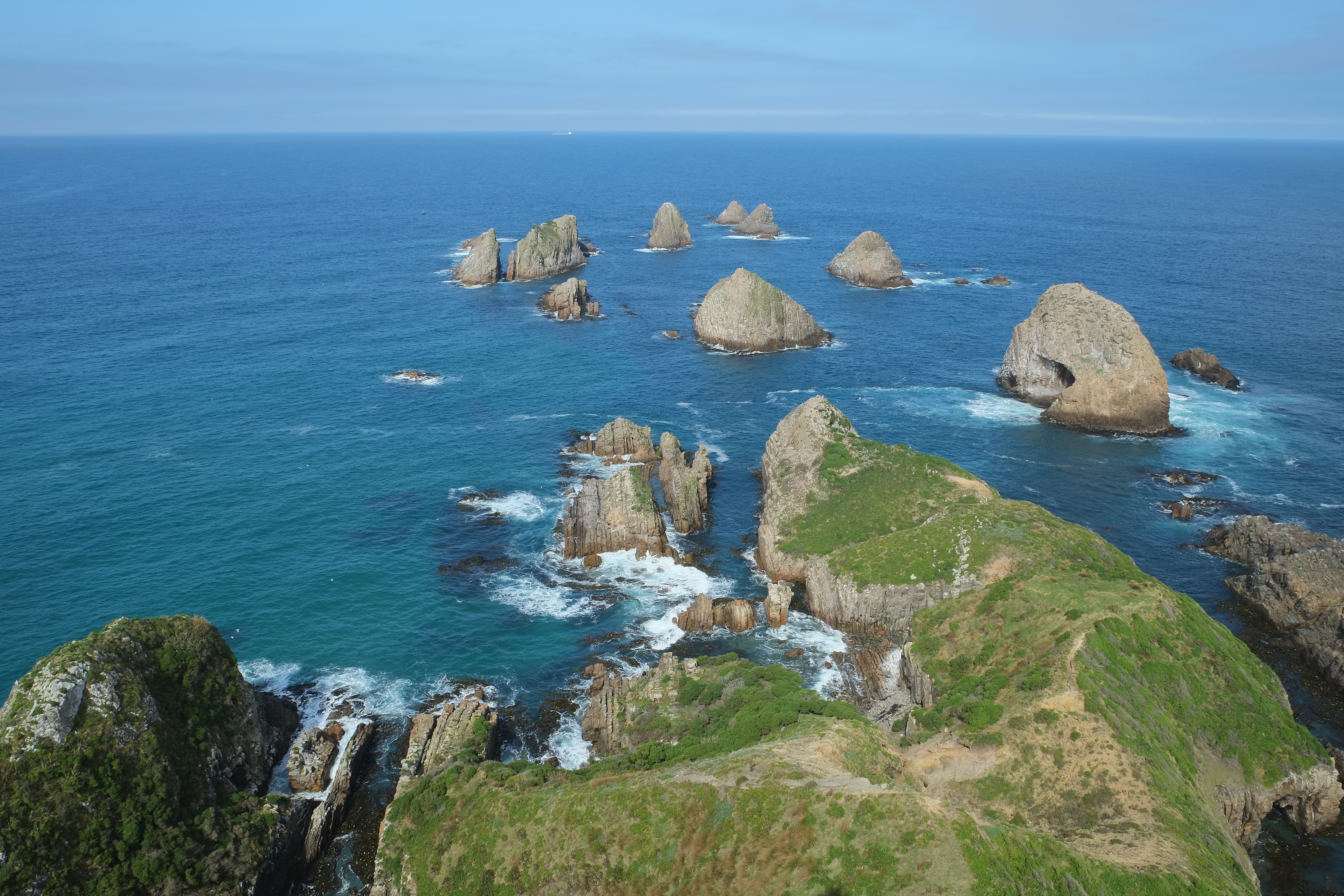
Nugget Point
The rocky islets appear first, scattered below the headland like stones dropped by a careless giant. From the air, Nugget Point looks fragile -- a narrow finger of land jutting into the South Pacific, tapering to a white lighthouse at its tip. But this place has endured since long before anyone thought to put a light on it. The Nuggets, as locals call those wave-battered rocks, host one of the densest concentrations of marine wildlife on New Zealand's coast: fur seals hauled out on every ledge, penguins shuffling through the surf at Roaring Bay, gannets wheeling overhead in slow circles. It is a place where the land gives way reluctantly to the sea, and the sea pushes back with equal stubbornness.
A Light Against the Dark
Ships once dreaded this stretch of the Otago coast. The headland sits where currents collide and swells wrap unpredictably around submerged rock, making it a particular hazard for the small trading vessels that worked the route to the Clutha River. In 1869, workers quarried local stone and began building a lighthouse on the point's outermost edge, 76 meters above the water. It started operating on 4 July 1870. For decades, an oil burner cast its beam across the Southern Ocean. A 1,000-watt lamp replaced it in 1949, powered by a diesel generator until mains electricity reached the headland in the 1960s. Automation came in 1989. Today, Maritime New Zealand monitors the light by computer from afar, but the stone tower still stands exactly where those 19th-century builders placed it, weathered but unmoved.
The Menagerie Below
Walk the 20-minute track to the lighthouse viewing platform and you descend into a world of noise. Australasian gannets dive from height, folding their wings into arrows before hitting the water. Royal spoonbills sweep their flattened bills through shallow pools. Below the cliff edge, New Zealand fur seals lie draped across the Nuggets in every posture of indolent contentment, their barking carrying up on the wind. But the headland's most celebrated residents are harder to spot. At Roaring Bay, on the south side of the point, a small colony of yellow-eyed penguins -- one of the world's rarest penguin species -- comes ashore in the late afternoon. A bird hide at the lower car park offers patient visitors a chance to watch them waddle up the beach. On a good day, you might also glimpse southern elephant seals, New Zealand sea lions, Hector's dolphins close to shore, or the dark fins of orca cutting through the kelp.
The Fight Over the Water
The headland itself has been a 47-hectare scientific reserve for years, but the marine area surrounding it has no special protection. This absence has sparked a long-running argument. The Department of Conservation has twice proposed a marine reserve around Nugget Point, and twice met fierce resistance. The small communities along this coast -- Kaka Point and its neighbors -- still depend on fishing. For families whose livelihoods come from these waters, a reserve feels less like conservation and more like eviction. Industry groups like the Seafood Industry Council have lined up alongside the fishers. On the other side, University of Otago marine scientists argue that the waters around the Nuggets harbor ecosystems found nowhere else, and that protection would ultimately benefit everyone. The Royal Forest and Bird Protection Society has pushed for an even larger reserve than the government has proposed. Decades on, the debate remains unresolved, a reminder that the boundary between preservation and livelihood is never a clean line.
At the Edge of the Catlins
Nugget Point marks the northern gateway to the Catlins, one of New Zealand's least-visited coastal stretches. The nearest village is Kaka Point, a handful of houses and a few beds for travelers. The sealed Nuggets Road climbs the bluff to two car parks, from which the choices are simple: walk left toward the lighthouse, or walk right toward Roaring Bay. Either takes about 20 minutes. The Southern Scenic Route passes nearby, threading south through podocarp forest and past petrified wood and cathedral caves. In this landscape, Nugget Point serves as both destination and threshold -- the place where the tamed coast of Otago gives way to something wilder and less certain, where the human world thins out and the animal world takes over.
From the Air
Located at 46.45S, 169.81E on the southeastern coast of the South Island. The narrow headland and its rocky islets (The Nuggets) are clearly visible from above, with the white lighthouse at the tip serving as a strong visual reference. Nearest airfield is Balclutha Aerodrome (NZBA), roughly 40 km northwest. Approach from the east over the Pacific for the most dramatic view of the point extending into the sea. Best seen at 2,000-4,000 ft in clear conditions. The Catlins coastline stretches south from here.