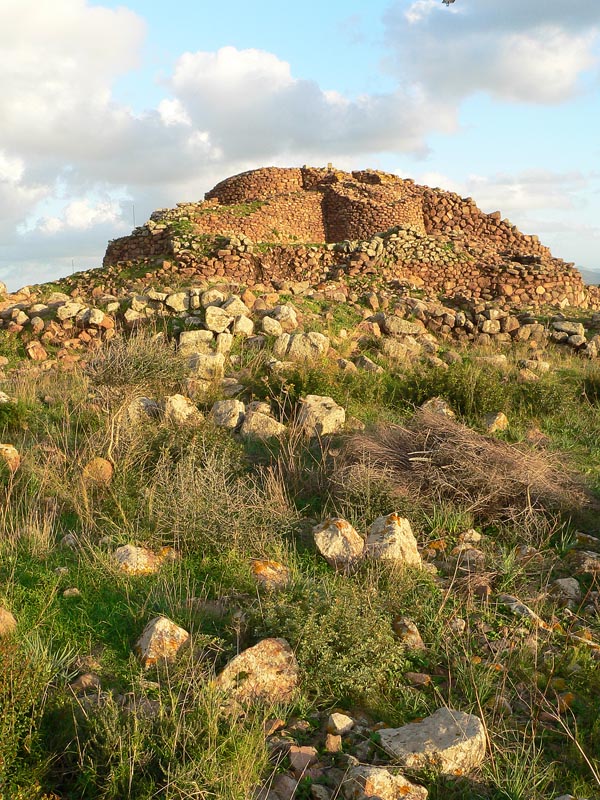
Nuraghe Seruci
From the hilltop where the nuraghe stands, you can see the sea. That was the point. Sometime during the Bronze Age -- roughly 1500 to 800 BC -- the people who built the Nuraghe Seruci chose this spot in southwestern Sardinia for its commanding view of the surrounding coast and countryside. They raised a central stone tower, then surrounded it with five or six additional towers linked by a defensive wall. Around this fortress, they built a village of approximately one hundred circular stone huts, making Seruci one of the largest Nuragic settlements on the island.
Towers of Stone
The nuraghe is classified as a 'complex' type -- the most architecturally ambitious category of these uniquely Sardinian structures. A central tower, its upper levels now collapsed, once rose high enough to survey the entire coastal plain and the Mediterranean beyond. Around it, five or six subsidiary towers created a fortified compound, their summits originally crowned with stone shelves that may have served as battlements or observation platforms. A circuit wall tied the whole complex together. Sardinia has over 7,000 nuraghi scattered across the island, more megalithic monuments than any comparable area in the Mediterranean. But Seruci stands out for its combination of military architecture and the sheer scale of the civilian settlement that grew around it.
A Village of Innovation
The settlement sprawls across six hectares, organized into six distinct 'residential areas' separated by narrow streets -- a level of urban planning that challenges assumptions about Bronze Age communities. The huts are circular, built from the same local stone as the nuraghe, but several display architectural features rarely found in other Nuragic villages. Some have interior partition walls dividing the living space into separate rooms, and others show the addition of annexes in various shapes attached to the main circular structure. These innovations suggest a community that was adapting and experimenting, finding new solutions to the domestic needs of a growing population. At the center of the village sits a hut of exceptional size, far larger than its neighbors, which archaeologists believe served as a communal meeting hall -- a space for the decisions that governed community life.
The Giants' Tomb
On a nearby hill, a giants' tomb completes the picture of Nuragic life and death at Seruci. These distinctive burial monuments -- long stone chambers covered by earth, with a curved forecourt formed by tall upright slabs -- are the characteristic funerary architecture of Bronze Age Sardinia. The name 'giants' tomb' was given by later inhabitants of the island who, finding these massive stone structures scattered across the landscape, attributed them to a race of giants. The proximity of the tomb to the village and nuraghe speaks to the integration of the living and the dead in Nuragic society. The dead were not buried far away; they remained close, part of the community's physical and spiritual landscape.
Rediscovery in the Iglesiente
The nuraghe sits in the municipality of Gonnesa, in the Iglesiente region of southwestern Sardinia -- an area better known today for its mining heritage than its prehistory. Italian archaeologist Antonio Taramelli first investigated the site in 1917, describing it as a 'Nuragic citadel.' Further excavations in the 1980s by V. Santoni and G. Bacco uncovered domestic artifacts and architectural details that illuminated daily life in the settlement. Walking the site today, the scale of the village is what registers most powerfully. A hundred huts, six neighborhoods, streets between them, a meeting hall at the center, a fortress above, and a tomb for the dead on the next hill. This was not a temporary camp or a defensive outpost. It was a town -- one of the earliest in the western Mediterranean -- and its stone walls have outlasted every civilization that came after it.
From the Air
Located at 39.25N, 8.42E in southwestern Sardinia, Italy, in the municipality of Gonnesa in the Iglesiente region. The site is on a hill near the coast with views toward the Mediterranean. Nearest airports: Cagliari Elmas Airport (LIEE), approximately 55 km southeast, and Decimomannu Air Base. The mining landscape of the Iglesiente and the coastline near Portoscuso are visible landmarks from altitude.