Nusa Ceningan: The Smallest Sister Between the Seaweed and the Cliffs
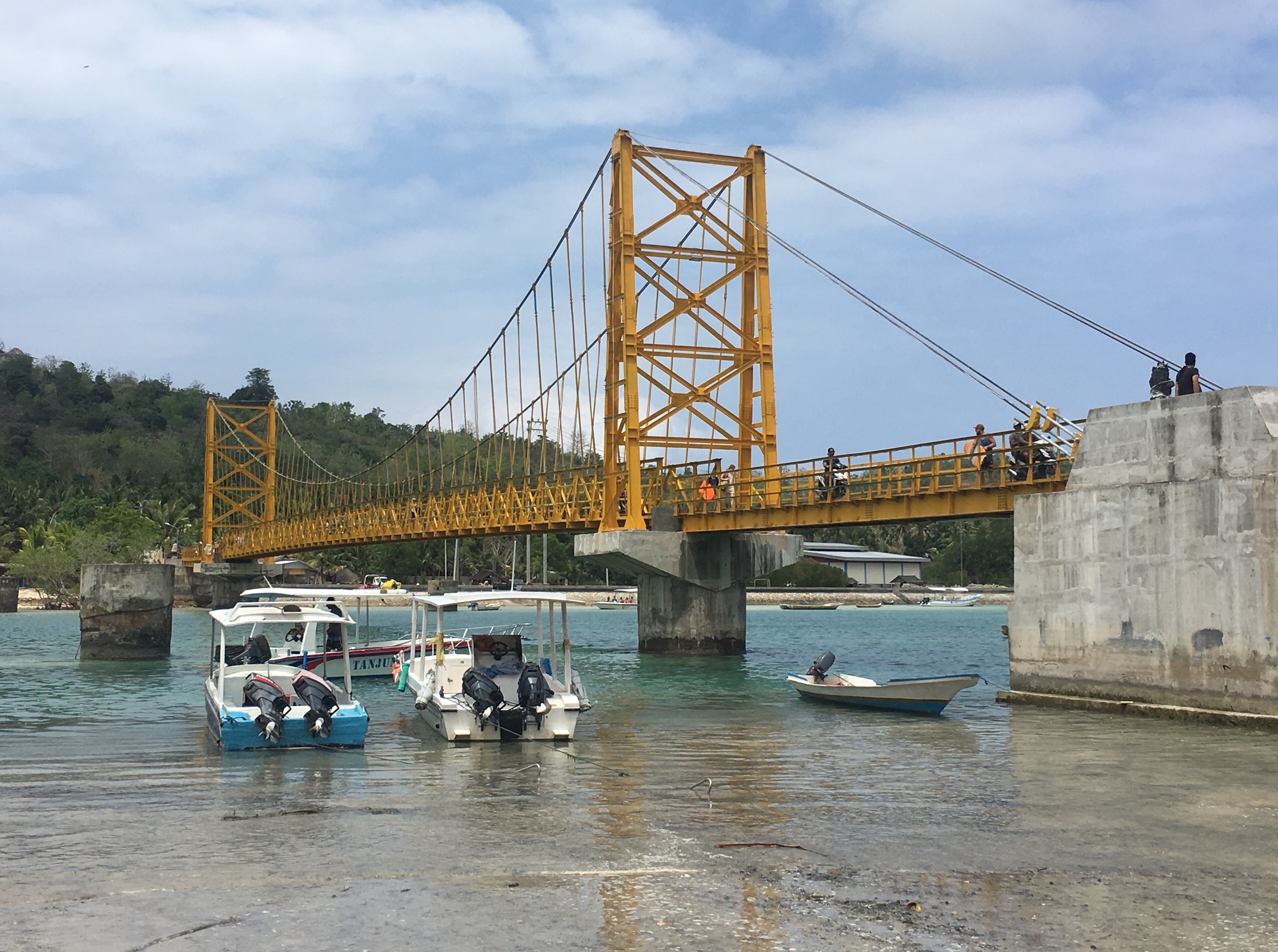
The yellow bridge connecting Nusa Lembongan to Nusa Ceningan collapsed in 2016, killing nine people. It has since been rebuilt, and most visitors crossing it today have no idea they are walking over a site of tragedy. That bridge is the only land link to Nusa Ceningan - a small island tucked between its larger siblings, Nusa Lembongan to the northwest and Nusa Penida to the southeast. None of the three islands has an airport. You arrive by boat from Bali, then by bridge or boat between them. The effort filters the crowds. What remains is an island that tourism has found but not yet consumed.
Three Islands, One Strait
Nusa Ceningan belongs to a trio of islands lying southeast of mainland Bali, separated from it by the Badung Strait. Nusa Penida is the largest, a rugged limestone plateau with dramatic sea cliffs. Nusa Lembongan is the most developed, its beaches lined with dive shops and beachfront cafes. Ceningan is the smallest and quietest of the three, administratively part of Lembongan Village in the Nusa Penida District of Klungkung Regency. Its population of roughly 1,523 people spreads across two administrative hamlets - Ceningan Kawan and Ceningan Kangin - and six customary hamlets with names that map the island's geography: Parangan Tengah, Ambentiying, Ceningan Tengah, Anggrek, Batumelawang, and Gili Mekarnadi. It is a place small enough that everyone knows everyone else.
The Seaweed Farms
The estuarine channel between Lembongan and Ceningan tells the island's older story. Before tourism arrived, seaweed farming was the primary livelihood here. Farmers cultivate it in shallow waters using lines strung between wooden stakes, the green and brown fronds drying on racks along the shore. The seaweed is harvested for carrageenan, a thickening agent used in food processing worldwide. It is unglamorous work, timed to the tides and dependent on water quality, but it shaped the rhythm of life on these islands for generations. Pristine mangrove forests line parts of the channel, their tangled root systems providing nursery habitat for fish and stabilizing the coastline against erosion. The mangroves and the seaweed farms together create an ecosystem where human cultivation and natural processes overlap in ways that benefit both - a balance that increasing boat traffic and coastal development have begun to test.
Ridgeline Sunsets
Nusa Ceningan's topography is modest but rewarding. A central ridge runs the length of the island, and from its high points the views open in every direction. To the west, the channel and Nusa Lembongan, with mainland Bali beyond - Mount Agung's volcanic cone visible on clear days. To the east, the larger mass of Nusa Penida with its sheer cliffs dropping into deep water. The island offers scenic roads and paths that reward exploration by motorbike or on foot, winding through small villages and past Hindu temples adorned with the characteristic black-and-white checkered cloth of Balinese ceremony. Sunset from the Ceningan ridge is the island's quiet spectacle - the sun dropping behind Bali's volcanic profile while the strait below turns gold, then purple, then dark.
The Cliff at Mahana Point
Since 2009, tourism has been growing on Nusa Ceningan, slowly and on the island's own terms. The main attraction is the Mahana cliff jump, located on the southeastern coast at Mahana Point Bar. Two diving platforms - one at five meters, one at thirteen - extend over a natural channel in the rock where the ocean surges in and retreats. Jumping is only permitted when the tide is high enough to ensure safe depth below, a rule the bar's staff enforce strictly. The thirteen-meter platform is not for the hesitant. Surfers come too, drawn by a notable break off Ceningan's coast that offers uncrowded waves compared to the more popular spots on Nusa Lembongan. Beyond the cliff jump and the surf, the island's appeal is simpler: quiet roads, small warungs, and the sense of being somewhere that has not yet been optimized for the visitor experience.
Holding the Line
Nusa Ceningan exists in an uneasy space between the old economy and the new. Seaweed farming continues, but tourism revenue grows each year. The rebuilt yellow bridge brings day-trippers from Lembongan who ride motorbikes across the island, stop at the cliff jump or a beachside bar, and leave by evening. Some stay longer, renting rooms in the hamlets. The infrastructure is basic - narrow roads, limited electricity, water trucked in during dry spells. Whether Ceningan follows Lembongan's path toward full tourist development or maintains its quieter character depends on choices being made now, by the 1,523 people who call it home. For the moment, the island holds its balance. The seaweed still dries on the racks. The mangroves still stand. The ridge still offers its sunset to whoever climbs it. Ceningan is not untouched, but it is still itself.
From the Air
Nusa Ceningan (8.70S, 115.45E) is the smallest of three islands southeast of Bali, visible from altitude as a slender landmass between Nusa Lembongan (northwest) and Nusa Penida (southeast). The Badung Strait separates the island group from mainland Bali. None of the three islands has an airport; nearest is Ngurah Rai International (WADD/DPS) approximately 25km northwest, with runway 09/27 (3,000m). The yellow bridge connecting Ceningan to Lembongan is visible from low altitude. The estuarine channel between the two islands shows the grid pattern of seaweed farms. From 3,000-5,000 feet, the three-island archipelago and its relationship to Bali's coast are clearly legible. Tropical weather; strong currents in the strait.