Nutibara Hill
Medellin has seven guardian hills, and Nutibara is the one the city decided to keep. At 80 meters tall, it is not imposing. It would barely register as a bump on a topographic map of the Andes. But Cerro Nutibara sits at the geographic center of the Aburra Valley, on the west bank of the Medellin River, and for a city that paved over most of its natural landscape during a century of rapid industrialization, this modest hill became something precious: 333,000 square meters of green in a valley of concrete. One of the last natural ecosystems preserved within the city limits, Nutibara is where Medellin goes to remember what the valley looked like before the valley became a metropolis.
Three Names for One Hill
When the Spanish conquistadors arrived, they called it Marcela of the Parra Hill after its landowner. A family named Cadavid later purchased the property, and the hill became the Hills of the Cadavides. For centuries it sat on the far side of the Medellin River from the colonial town, which was then a modest settlement called the Villa de Nuestra Senora de la Candelaria. In 1927, the Municipality of Medellin bought the hill for 50,000 pesos to create a public park. Two years later, the Society of Public Improvements proposed renaming it to honor Nutibara, one of the most powerful indigenous caciques of the Antioquia region, whose dominion once extended across much of western Colombia. The name stuck. A private landmark became a public one, its identity anchored to the land's history before colonization.
A Park Rises from the Plans
After the renaming in 1929, the Municipality authorized the Society of Public Improvements to design a recreational park. A master plan approved in 1939 envisioned roads for access, gazebos and kiosks, lakes and waterfalls linked by rustic bridges, tree-lined footpaths, viewpoints overlooking the valley, and a restaurant at the summit. The vision was ambitious for a city of its size, and the execution unfolded over decades rather than years. What emerged was not a manicured European park but something rougher and more alive -- a green space that preserved the hill's rocky, wooded character while adding infrastructure for the hundreds of thousands of visitors who would eventually climb it each year.
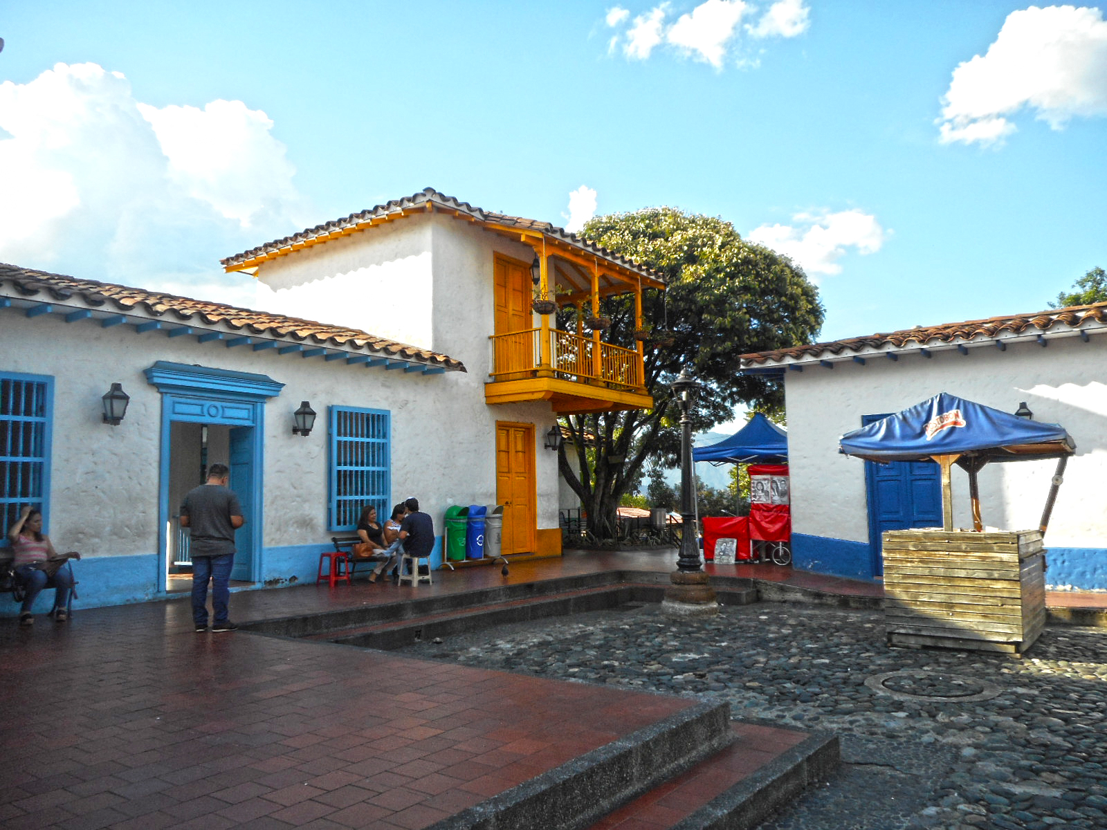
The Village at the Top
At the summit sits Pueblito Paisa, built in 1977 as a full-scale replica of a traditional Antioquia mountain town. Cobblestone streets wind past colonial-style buildings with whitewashed walls and clay-tile roofs -- a church, a town hall, a general store, a barbershop -- all arranged around a small central plaza. It is a piece of nostalgic architecture that recreates the Paisa region's rural heritage for a population that had overwhelmingly migrated into the urban valley below. From the Pueblito's terrace, visitors look out over a panoramic view of Medellin that stretches from one mountain wall to the other, the city filling the valley floor in an unbroken sprawl of brick and glass.
Sculptures, Poetry, and Rock Concerts
In 1953, sculptor Jose Horacio Betancur created the Madremonte, the first monumental sculpture commissioned for the hill. Three decades later, in 1983, former President Belisario Betancur Cuartas championed the creation of a formal sculpture park at the hill's base, with the Medellin Museum of Modern Art coordinating the installation of ten works by national and international artists. On the northern slope, the open-air Carlos Vieco Theater -- named for the Medellin-born composer Carlos Vieco Ortiz -- has hosted audiences of up to 3,800 since it opened in 1984. Every June it becomes the stage for the International Poetry Festival, and throughout the year it draws rock concerts like the Altavoz Festival. During December, the Christmas lighting transforms the hill into one of the brightest points in a city famous for its holiday illuminations.
From the Air
Located at 6.237N, 75.580W on the west bank of the Medellin River in the geographic center of the Aburra Valley. Nutibara Hill rises 80 meters above the valley floor and is distinctive as an isolated green mound amid dense urban development. Recommended viewing altitude: 2,000-4,000 feet AGL. Olaya Herrera Airport (SKMD) is approximately 1.5 nautical miles east-southeast. Jose Maria Cordova International (SKRG) is about 19 nautical miles southeast in Rionegro. The hill is easily identifiable from the air by its tree-covered dome shape contrasting with the surrounding city grid.