Nyenchen Tanglha Mountains
Chris Bonington was sixty-two when he first attempted Sepu Kangri in 1997. He returned the following year and failed again. The 6,956-meter peak in the eastern Nyenchen Tanglha range would not be climbed until 2002, when Americans Mark Newcomb and Carlos Buhler finally reached the summit. This is the nature of the Nyenchen Tanglha: a 700-kilometer wall of rock and ice running parallel to the Himalayas across the Tibetan Plateau, containing more than 240 peaks above 6,000 meters, most of them unclimbed. The range is one of the great mountain wildernesses left on Earth, and the reason is not mystery but altitude, remoteness, and ice.
The Spine of the Transhimalaya
The Nyenchen Tanglha range forms the eastern section of the Transhimalaya system, running roughly parallel to the Himalayas north of the Yarlung Tsangpo River. Together with the Gangdise Mountains to the west, it creates a continental divide separating the Yarlung Tsangpo basin in the south from the vast endorheic basins of the Changtang -- the great northern plateau where rivers flow into salt lakes rather than the sea. The range's highest peak, Mount Nyenchen Tanglha, reaches 7,162 meters in Damxung County, about 100 kilometers northwest of Lhasa. Three other peaks exceed 7,000 meters: Nyenchen Tanglha II at 7,117 meters, Nyenchen Tanglha III at 7,046 meters, and Jomo Gangtse at 7,048 meters. The southern face drops precipitously, losing 2,000 meters in elevation, while the northern side descends more gently across roughly 1,000 meters.
An Ocean of Ice
The eastern Nyenchen Tanglha holds a concentration of glaciers that rivals anywhere outside the polar regions. According to the Lanzhou Glaciers Research Institute, the range contains 2,905 glaciers covering 5,898 square kilometers. Two-thirds of these glaciers lie in the eastern section, which intercepts the southwest monsoon as moist air is forced upward at the Yarlung Tsangpo's Grand Bend. This collision of warm, wet air and cold altitude produces the highest rainfall on the Tibetan Plateau and feeds glacial growth on a massive scale. Thirty-two glaciers exceed 10 kilometers in length. The largest, Kyagquen Glacier, covers 207 square kilometers and extends 35.3 kilometers, its tongue descending to 2,530 meters in an area of mountain forests -- an improbable meeting of ice and trees.
The Alps of Tibet
The eastern section of the range has been called the Alps of Tibet, though the comparison flatters the Alps. Most peaks here remain unclimbed, their approaches blocked by glacial terrain, unpredictable weather, and the logistical challenges of operating at extreme altitude in one of Earth's most remote regions. Sepu Kangri, with its 2,213 meters of topographic prominence, resisted Bonington and Charles Clarke twice before Newcomb and Buhler succeeded in October 2002. In 2005, British alpinist Mick Fowler and Chris Watts made the first ascent of Kajaqiao. Two years later, Fowler returned with Paul Ramsden to climb Manamcho, known as the Matterhorn of the East Nyenchen Tanglha for its steep, pyramidal profile. Each expedition represented years of planning for a few days of climbing in conditions where the margin for error is measured in hours.
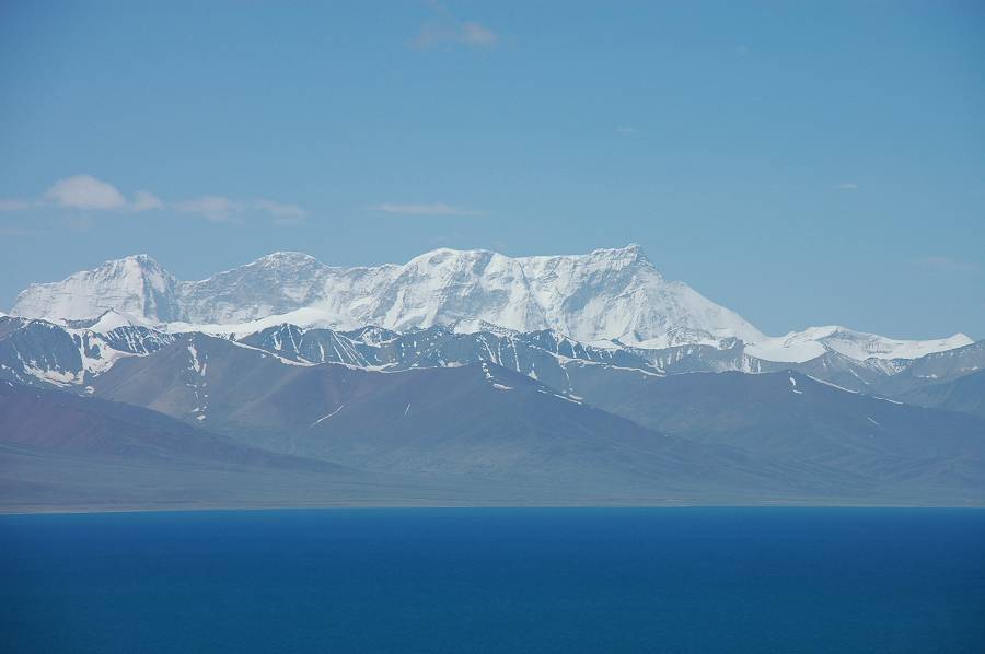
Namtso and the Sacred Landscape
The western Nyenchen Tanglha rises southeast of Namtso, one of the highest large lakes in the world and a site of deep spiritual significance in Tibetan Buddhism. The range forms the dramatic backdrop to the lake's turquoise waters, its snow-capped peaks reflecting in the surface at over 4,700 meters. The Lhasa River, the largest tributary of the Yarlung Tsangpo, drains the northeastern section of the western range, flowing through the capital city that has been the center of Tibetan civilization for fourteen centuries. The Tro La Pass at 5,432 meters divides the western and eastern sections of the range near Lhari Town, marking the transition from the politically central Lhasa watershed to the wilder, more glaciated eastern reaches where the mountains still hold their secrets.
From the Air
The Nyenchen Tanglha Mountains extend across 30.37N, 90.58E with peaks exceeding 7,162m. This is extremely high terrain requiring careful altitude planning. The range runs roughly west-east for 700km parallel to the Himalayas. Lhasa Gonggar Airport (ZULS) lies to the southeast. Namtso lake (4,718m) is visible northwest of the western section. Mount Nyenchen Tanglha (7,162m) is the highest peak, located in Damxung County approximately 100km northwest of Lhasa. Expect severe turbulence, icing conditions, and rapidly changing weather. Maintain significant clearance above ridgelines.