Oak Island Light
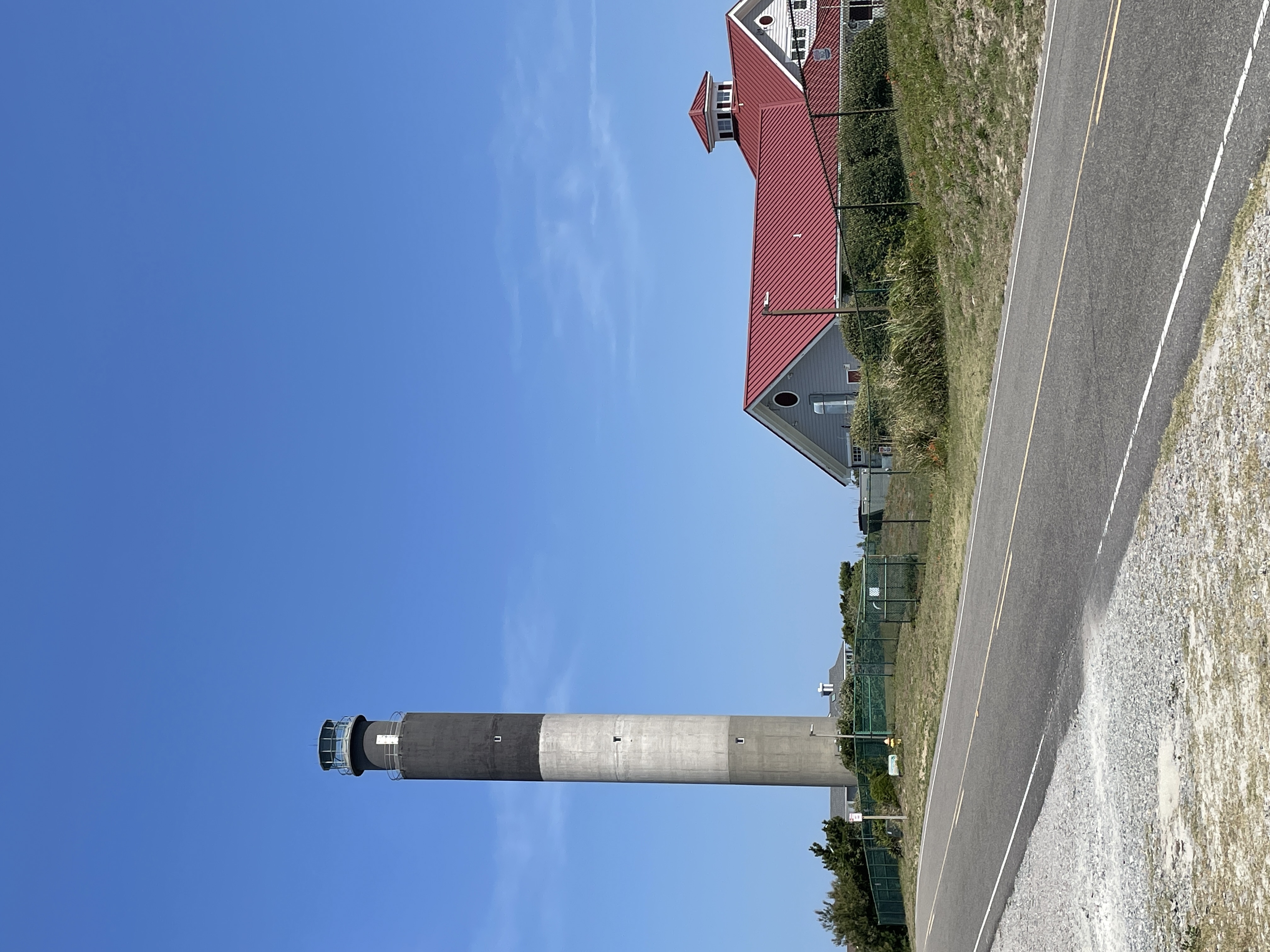
The colors are permanent. When Brinkley, W.F. & Son Construction Co. poured the Oak Island Lighthouse in 1957-58, they mixed the pigments directly into the concrete -- black for the top 52 feet, white for the middle 50, cement grey for the bottom 40. No paint to chip or fade in the salt wind. It was a fitting choice for a structure built to endure at the edge of the Atlantic, where the Cape Fear River meets the open ocean and the North Carolina coast has been claiming ships for centuries.
The Last of Its Kind
The Oak Island Lighthouse belongs to the closing chapter of American lighthouse construction. By the late 1950s, automated navigation systems were steadily replacing the romantic old towers, and few new ones were being commissioned. Built at a cost of $110,000, the Oak Island Light went into service in May 1958, replacing the Cape Fear Light, a steel skeleton structure on Bald Head Island that was demolished the same year. That older light had itself replaced the 1817 Bald Head Light -- affectionately known as Old Baldy -- which still stands today as a tourist attraction. For a brief period from 1958 to 1962, the Oak Island Light held the distinction of being the brightest lighthouse in the United States. The Charleston Light in South Carolina eventually claimed that title.
Concrete and Bedrock
The lighthouse rests on 24 pilings driven 67 feet deep to bedrock, each 10 inches round and filled with concrete, capped by a 30-foot-wide, 3-foot-deep octagonal concrete base. The tower rises 142 feet of poured concrete, crowned by an 11-foot aluminum and glass light enclosure that brings the total height to 153 feet. Sited on a small knoll, nautical charts mark the light at 169 feet above sea level. Inside, the uniform diameter runs just over 16 feet 4 inches, with exterior walls 8 inches thick. Visitors who climb to the top navigate 131 steps arranged not in the classic spiral pattern but in steep, straight sections with eight landings -- a configuration known as a ship's ladder. Marine Corps helicopters lifted the lantern enclosure into place atop the tower during construction, a striking image of mid-century engineering muscle applied to an ancient maritime tradition.
Fire Next Door
The lighthouse sits adjacent to the Oak Island Coast Guard Station at the east end of Oak Island in Caswell Beach, Brunswick County. In February 2002, the Coast Guard station caught fire and burned to the ground while the lighthouse stood untouched, its thick concrete walls impervious to the blaze next door. The station was rebuilt over its existing foundation to closely resemble the original. The following year, the federal government declared the lighthouse surplus property. In 2004, the Town of Caswell Beach took ownership of the tower, surrounding grounds, and adjacent oceanfront property, with the Coast Guard retaining responsibility for operating the beacon. The transfer agreement requires the town to maintain the site for recreation. In April 2007, the Oak Island Lighthouse earned a place on the National Register of Historic Places, and in 2016, the International Chimney Corporation -- the same company that famously moved the Cape Hatteras Lighthouse -- completed a major exterior rehabilitation.
From Aerobeacons to LEDs
For decades, four 2.5-million-candlepower aerobeacon lenses rotated inside the lantern room, producing four one-second bursts of light every ten seconds. But power fluctuations eventually burned out the rotation motor, and the Coast Guard's Aids to Navigation Team decided to seize the opportunity for a full technology upgrade. In December 2020, 16 new LED lights were installed and brought online, assembled and compliance-tested in New London, Connecticut. The new configuration replicates the original flash pattern -- four one-second pulses followed by six seconds of darkness -- while being better protected from coastal weather. The LEDs push the light's visibility to 20.5 nautical miles, nearly 24 statute miles, across the open Atlantic. The lighthouse grounds remain open year-round, and the Friends of Oak Island Lighthouse, a citizens group, manages the tower and the walkway to the beach.
From the Air
The Oak Island Lighthouse is located at approximately 33.89N, 78.04W, at the east end of Oak Island near the mouth of the Cape Fear River. The tricolor tower (grey, white, black from bottom to top) is clearly visible from the air against the barrier island landscape. Cape Fear River runs to the north and east, with Bald Head Island visible to the southeast across the river mouth. Wilmington International Airport (KILM) lies approximately 20 nautical miles to the north. The surrounding area features barrier island beaches, coastal marshes, and the Intracoastal Waterway. Best viewed from 2,000-4,000 feet on approach from the ocean side.