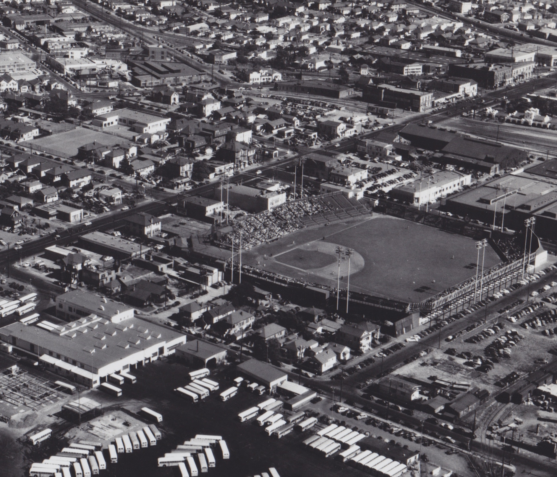
Oaks Park
The outfield wall stood where Pixar animators now park their cars. For forty-two years, the Oakland Oaks played baseball on a city block in Emeryville bounded by 45th Street, San Pablo Avenue, Park Avenue, and Watts Street -- an 11,000-seat stadium wedged between a streetcar line and a horse racing track. Today, not a single physical trace of the ballpark remains. The block was absorbed into Pixar Studios' 2011 expansion, and the only marker is a commemorative plaque. But between 1913 and 1955, Oaks Park was the heartbeat of East Bay baseball, a place where Pacific Coast League rivalries played out under California sunshine and the crack of wooden bats carried across the flatlands to the bay.
One Man's Two Teams
The story of Oaks Park begins with a peculiar arrangement. J. Cal Ewing, a founding father of the Pacific Coast League, owned both the Oakland Oaks and the San Francisco Seals from 1903 through the early 1920s. Under his dual ownership, the Oaks spent most of their home games not in Oakland but across the bay at Recreation Park in San Francisco, which had opened in 1907. Thursday games and Sunday mornings were played on the East Bay side; the rest belonged to San Francisco. Even after the Oaks moved back to their own ballpark in Emeryville, they continued playing a handful of games each season at Recreation Park. It was not until Ewing relinquished one of his franchises sometime in the 1920s that the Oaks began playing all their games on home soil. The short-lived Mission Wolves also used Oaks Park for some 1914 home dates, adding another chapter to the stadium's role as a PCL crossroads.
Streetcars to the Bleachers
Location was Oaks Park's great advantage. San Pablo Avenue, one of the East Bay's main commercial arteries, ran along the third-base side, and a major streetcar line ensured fans could reach the park without an automobile. A few blocks south, a Key System station at Yerba Buena Avenue connected the ballpark to transbay commuter rail lines that brought fans from San Francisco and points across the East Bay. The park held 4,000 in the grandstand and 7,000 in two bleacher sections -- modest by major league standards but substantial for a minor league venue. Field dimensions were cozy: 335 feet down the left field line, 323 down the right, and 400 to center. A California Jockey Club racetrack operated a block away, making the neighborhood a magnet for anyone looking to wager on something, whether it had legs or a batting average.
Decline and Displacement
By the early 1950s, Oaks Park was deteriorating. The facility had not kept pace with fan expectations, and poor maintenance accelerated a steep decline in attendance. The Oaks limped through their final seasons in Emeryville, playing their last game at the park in 1955 before relocating to Vancouver for the 1956 season. The move proved prescient in a way the franchise could not have fully anticipated. Two years later, the New York Giants relocated to San Francisco, transforming the Bay Area baseball landscape overnight. A minor league team competing for attention against a storied major league franchise would have faced near-impossible odds. The Oaks' departure, forced by a crumbling stadium, may have spared them a slower, more painful extinction.
From Diamond to Digital
After the Oaks left, the ballpark site entered a long limbo. For decades, the block sat partly as an empty, fenced-off lot -- a gap in the Emeryville streetscape where weeds grew through old asphalt. When Pixar Studios expanded in 2011, the company's second phase swallowed the land where Watts Street once marked the right-field boundary. What had been a diamond became a parking lot, a bicycle path, and a strip of public park facing San Pablo Avenue. Across the street, the Oaks Card Club carries the team's name, though few of its patrons likely know why. A plaque commemorating the Oakland Ball Park is the only formal acknowledgment that eleven thousand fans once gathered here to watch baseball played at the highest level outside the majors. The transformation is almost poetic: a place built for live spectacle, replaced by a studio that creates spectacle in pixels.
From the Air
Located at 37.833N, 122.282W in Emeryville, California, between Oakland and Berkeley. The former ballpark site is now part of the Pixar Studios campus, identifiable from the air by Pixar's distinctive main building and surrounding parking areas along San Pablo Avenue. Best viewed below 2,000 feet AGL. Nearest airports: Oakland International (KOAK, 8 nm south), Buchanan Field (KCCR, 16 nm northeast). The San Francisco-Oakland Bay Bridge is visible to the southwest, and the Emeryville waterfront and Interstate 80 corridor provide strong visual references.