Ocean Observatories Initiative
The ocean does not stay still long enough to be understood from a ship. Research vessels can spend weeks at a single location taking measurements, but the ocean changes on timescales ranging from seconds to decades, and the picture built from periodic expeditions has enormous gaps. The Ocean Observatories Initiative — a network of more than 900 science-driven sensors and platforms in the Atlantic and Pacific Oceans — was built to fill those gaps. Commissioned in 2016 with an annual operating budget of approximately $44 million, it measures physical, chemical, geological, and biological variables from the seafloor to the sea surface and the overlying atmosphere, continuously, and makes the data freely available to any researcher anywhere in the world.
Thirty Years from Idea to Water
The Ocean Observatories Initiative has a long prehistory. As early as 1987, the ocean sciences community began discussing what a permanent ocean observation infrastructure might look like. The International Ocean Network formed in 1993. The National Science Board approved the OOI as a potential Major Research Equipment and Facilities Construction project in 2000. Community workshops, design reviews, engineering assessments, and budget negotiations occupied most of the following decade.
In September 2009, the National Science Foundation and the Consortium for Ocean Leadership signed a cooperative agreement beginning the construction phase. The marine implementing organizations — Woods Hole Oceanographic Institution, University of Washington, and Oregon State University — began building the components: moorings, buoys, sensors, seafloor cable systems, and the software infrastructure needed to collect, transmit, and archive data from hundreds of instruments operating simultaneously across thousands of miles of ocean.
The OOI was commissioned in 2016. That gap between the first conversations in 1987 and operational capability in 2016 — nearly thirty years — reflects both the genuine complexity of the engineering challenge and the institutional realities of large-scale science infrastructure in the United States, where building major facilities requires sustained political will, multiple rounds of design review, and patience across budget cycles that rarely align with scientific timelines.
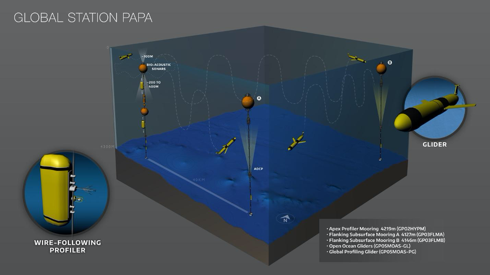
Scripps Institution of Oceanography at UC San Diego manages the OOI's global arrays — instrumented moorings and gliders deployed in four locations chosen for their scientific significance and their inaccessibility to conventional ship-based measurement: the Argentine Basin in the South Atlantic, the Irminger Sea near Greenland, the Southern Ocean, and Station Papa in the North Pacific.
What Nine Hundred Sensors See
The OOI's network encompasses seven primary sites, including coastal arrays off the Oregon and Washington coasts, a cabled seafloor observatory on the Juan de Fuca tectonic plate (where the Pacific Plate dives beneath North America), and the four global arrays managed by Scripps. Each site deploys multiple instrument packages measuring different variables simultaneously.
The coastal and regional arrays capture processes that matter for fisheries, harmful algal blooms, ocean acidification, and the coastal weather systems that affect millions of people. The seafloor observatory on the Juan de Fuca Plate instruments one of the most geologically active regions accessible in the ocean — a spreading center where new seafloor is continuously being created, where hydrothermal vents support biological communities that derive energy from chemistry rather than sunlight, and where earthquake and tsunami generating subduction processes can be monitored in near-real time.
The global arrays address questions at the largest scales: how heat moves between the tropics and the poles, how the deep ocean exchanges gases with the atmosphere, how climate change is manifesting in remote ocean regions far from the direct influence of human activity. These questions require sustained observation over years and decades to answer, and sustained observation is precisely what the OOI was designed to provide.
All OOI data is freely available through the project's online data portal, open access without restriction. The decision to make the data freely available was deliberate and significant: ocean observing infrastructure is expensive enough that restricting access to the data it generates would limit the return on the public investment. By making the data available to any researcher, the OOI multiplies the scientific value of each sensor deployment by the number of investigators who might find the data useful — a number far larger than the teams that designed and built the system.
The Long View
The OOI's goal is to deliver data for a twenty-five-year-plus time period. That horizon is unusual in scientific infrastructure, where funding cycles often operate on much shorter timescales. The commitment to multi-decadal operation reflects the recognition that some of the most important ocean processes — the decadal oscillations that affect regional climate, the slow changes in deep ocean temperature and chemistry, the long-term consequences of ocean acidification — simply cannot be characterized on shorter timescales.
The ocean covers seventy percent of Earth's surface and absorbs both heat and carbon dioxide at rates that profoundly affect the climate system. Understanding how the ocean is changing, at what rate, in response to what forcing factors, and with what consequences for weather, fisheries, and sea level requires the kind of sustained, systematic observation that the OOI was built to provide. The data it collects will be used by researchers who have not yet begun their careers, to answer questions about ocean change that will only become apparent over decades of continuous record.
Scripps Institution of Oceanography, which manages the global arrays from its campus in La Jolla, has been studying the ocean since 1903. The OOI represents a new chapter in that tradition — not individual expeditions to specific locations, but continuous measurement across the full basin scale of the global ocean, for as long as the infrastructure is maintained and funded.
From the Air
The Ocean Observatories Initiative is managed in part by Scripps Institution of Oceanography at approximately 32.87°N, 117.25°W in La Jolla, at the southern end of the Torrey Pines Mesa overlooking the Pacific. The Scripps campus and its distinctive research vessels pier are visible from altitude as a developed promontory at the northern edge of La Jolla Cove. The actual OOI sensor arrays are deployed thousands of miles from San Diego in the open Atlantic and Pacific Oceans. Nearest airports: KMYF (Montgomery-Gibbs Executive, 8 miles east) and KSAN (San Diego International, 12 miles south).