Oceta Paramo
The path is called the Camino de la Otra Vida -- the Road of the Other Life. It begins in Mongui, one of the prettiest colonial towns in Boyaca, and climbs a thousand meters through fog and grassland before delivering hikers to a landscape that looks like nothing else on Earth. The Oceta Paramo, spread across 5,771 hectares of the Eastern Andes between 2,950 and 3,950 meters, is an ecosystem that exists only in the narrow band above the forest line and below the permanent snowline. Colombians call it the most beautiful paramo in the world, and after six to eleven hours of walking through its stone gardens and silver-green frailejones, most visitors do not argue.
Where the Frailejones Stand Guard
Frailejones -- plants of the genus Espeletia -- define the paramo. They grow in dense colonies, their rosettes of thick, woolly leaves trapping moisture from the near-constant fog. On the Oceta Paramo, four of Colombia's six Espeletia species are present: Espeletia barclayana, Espeletia jaramilloi, Espeletia congestiflora, and Espeletia argentea populate the lower elevations, while Espeletia grandiflora ranges across a wider altitude band. These are not fast-growing plants. At roughly one centimeter per year, a frailejone standing two meters tall has been alive for two centuries. Walking among them feels like moving through a crowd of silent, patient beings -- silver-haired and motionless, arranged in clusters that suggest intention rather than chance. Between them, grasses, mosses, and wildflowers fill the gaps. Bidens andicola adds splashes of yellow. Lupinus luisanae, a variant unique to Oceta, contributes purple spikes.
The Muisca and the Sweethearts
Long before hikers discovered Oceta, the Muisca people -- loyal to the iraca of Suamox (modern Sogamoso) -- considered this paramo sacred ground. In the lower reaches of the landscape, they carved oval depressions into the earth called Tortolitas, or "Sweethearts." These were birthing pools where Muisca women gave birth, the cold water a ritual element in welcoming new life. Petroglyphs found near the Tortolitas attest to a deeper symbolic presence. Higher up stands the Caja del Rey -- the King's Box -- a monolith roughly 8 meters high, 8 meters wide, and 15 meters long. Local legend holds that the cacique Sanoha once hid a fifteen-year-old girl inside the stone, and that she emerged naked one April night. Whether the story encodes a seasonal ritual or a founding myth, the monolith itself is striking -- a massive block of sandstone sitting in an open expanse of grass and fog, as deliberate-looking as anything human-made.
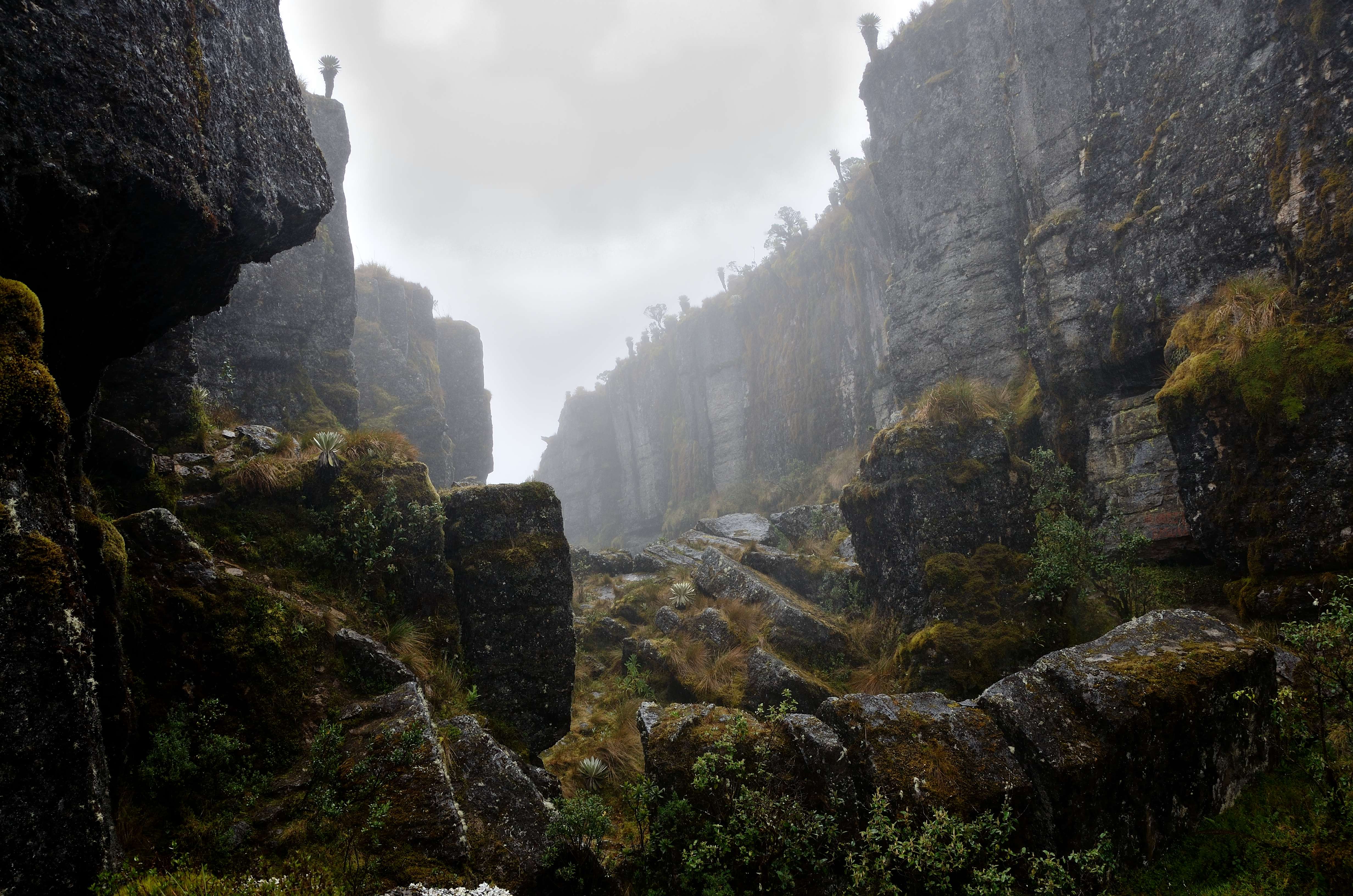
Stone and Deep Time
The rocks underfoot tell a story that stretches back far beyond human memory. The Oceta Paramo sits within the El Cocuy sub-basin, an inverted tectonic basin in the Eastern Ranges of the Colombian Andes. The main uplift occurred between the late Oligocene and Pleistocene, and the landscape is built from layers that span tens of millions of years: Paleocene sandstones and shales of the Socha Formation, Late Cretaceous Guadalupe sandstones, and the dark organic shales of the Chipaque Formation. The Guaduas Formation, straddling the Cretaceous-Paleocene boundary, contains coal seams that are still mined near Mongui. Pollen analysis has traced the transition from lowland tropical forest to cold mountain vegetation over the last five million years. The paramo as an ecosystem -- the frailejones, the mosses, the thin soils -- established itself during the Pliocene, making it geologically young but ecologically ancient in its adaptations.
A Sponge Above the Clouds
Paramos are hydrological engines. Their dense mats of moss and organic soil absorb rainfall like sponges and release it slowly into streams and rivers. On Oceta, marshes and small lakes dot the upper elevations. The largest body of water is the Laguna Negra, fed by the Penagos waterfall, dark and still against a backdrop of fog. The Calicanto, Tejar, and Morro Rivers all begin here, along with numerous smaller creeks that the locals call quebradas. Temperatures swing from near freezing on winter nights to 17 degrees Celsius on sunny days, and fog blankets the landscape so regularly that clear views feel like a gift. Andean condors ride the thermals above. Spectacled bears roam the lower margins, though they are rarely seen. White-tailed deer -- once the staple protein of the Muisca diet -- have been so heavily hunted over the centuries that encounters are now uncommon.
The Devil's Pulpit and the Road Back
South of the main hiking trail, a raised mesa-type formation called El Pulpito del Diablo -- the Devil's Pulpit -- stands like a natural watchtower. Nearby, the Ciudad de Piedra shelters a flat tabular stone known as the Mesa de los Sacrificios, where human offerings were reportedly made in pre-Columbian times. These formations, combined with the Caja del Rey and the Tortolitas, give Oceta a layered quality: every landmark carries both a geological and a cultural story. The hike itself is best undertaken in November or December, when the rains ease and visibility improves. An alternative route starts from the neighboring town of Mongua and reaches the Laguna Negra first. Either way, the paramo demands a full day -- ascending and descending a thousand vertical meters across terrain that shifts from pasture to rock garden to cloud forest and back. The road of the other life earns its name through sheer transformation: by the time hikers return to Mongui, the world below looks different than it did that morning.
From the Air
Located at 5.71N, 72.80W in the Eastern Ranges of the Colombian Andes, Boyaca Department. The paramo sits at 2,950-3,950 meters elevation east of the Altiplano Cundiboyacense. From the air, the paramo appears as a high-altitude grassland with distinctive circular frailejone clusters visible at lower altitudes. The nearest town is Mongui, accessible via the departmental capital Tunja. The closest airports are Juan Jose Rondon Airport (SKSO) in Sogamoso, approximately 30 km to the northeast, and Gustavo Rojas Pinilla Airport (SKTU) in Tunja. El Dorado International Airport (SKBO) in Bogota is roughly 230 km to the southwest. Expect fog and low cloud cover over the paramo, particularly in the afternoon.