North Fork Dry Diggings
They called it Dry Diggings. Not the romantic kind of name that California tourism boards would later invent, but an honest one - a description of what miners did here in 1848, scraping gold from ravines without the luxury of running water. The camp that grew at the confluence of the American River's north and middle forks changed names the way boom towns changed fortunes: North Fork Dry Diggings, then Woods Dry Diggings, and finally Auburn, after the town in New York that some early settler carried in memory. By April 25, 1851, Auburn had accumulated enough permanence to be declared the county seat of the newly formed Placer County. The buildings that line its oldest streets today are not relics preserved under glass. They are working structures, occupied and weathered, holding court and pouring wine in the same blocks where forty-niners once weighed gold dust on brass scales.
Brick and Ambition
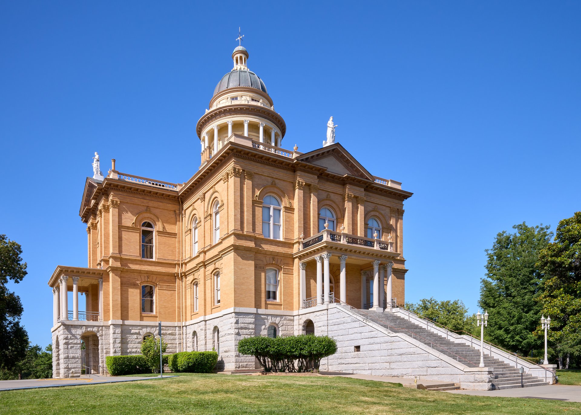
The Old Auburn Historic District sits in the ravine below the modern freeway interchange, a cluster of 19th-century commercial buildings that survived because they were built to last after fire taught the town's first lesson. Commercial Street dates to the 1850s, its brick facades rising from a time when Auburn was one of the earliest and most productive mining camps in California. Lawyers Row, built in 1855 at 299 Commercial Street, still stands - a stretch of offices constructed when legal disputes over mining claims were as common as the claims themselves. The crown of the district is the Placer County Courthouse, completed in 1897 on Maple Street, its neoclassical dome visible from the surrounding hills. The courthouse replaced an earlier wooden structure and was built with the confidence of a town that had already survived half a century of booms and busts. It remains in use today, one of the oldest continuously operating courthouses in California.
The Temple on Sacramento Street
Among the district's most unexpected buildings is the Auburn Joss House at 200 Sacramento Street. The current structure dates to 1930, but inside it holds a Taoist shrine from the 1860s, built by the Chinese laborers who came to Gold Country by the thousands. These men worked the placer mines after white prospectors moved on, panning what others had abandoned, and they built communities with temples, schools, and mutual aid societies. The joss house served the Ling Ying Association as a temple, a Chinese-language school, and a boarding house. That it still stands at all is remarkable - exclusion laws, fire, and demographic decline erased most of Gold Country's Chinatowns. Auburn's survived through a combination of stubbornness and luck, and the shrine inside connects the present district to a community that helped build it but is largely absent from its official history.
From Gold Dust to Plum Blossoms
Auburn's second act was agricultural. By the early 1900s, the gold was gone but the foothill climate proved ideal for fruit. The town became the largest plum producer in the nation, its orchards spreading across the same rolling terrain that miners had torn apart with hydraulic monitors decades earlier. The Travellers' Rest and Winery at 291 Auburn-Folsom Road embodies both eras - a stage roadhouse with a blacksmith shop that served travelers on the road between Sacramento and the mines, later adapted with a winery as the region's economy shifted from extraction to cultivation. The district's listing on the National Register of Historic Places came on December 29, 1970, recognizing not just individual buildings but the coherence of the whole - a collection of structures that together tell the story of a California foothill town that managed to outlast the single resource that created it.
The Ravine Below the Freeway
Today Old Auburn occupies a peculiar geographic niche. Interstate 80 and Highway 49 meet directly above it, their concrete overpass casting the district into a kind of architectural shadow. Drivers on the freeway pass over without knowing what lies beneath - a complete 19th-century downtown tucked into the natural ravine where miners first dug. The district draws visitors who find it by accident as often as by intention, wandering down from the modern town above into streets where the scale suddenly shifts. Buildings are lower, closer together, built for pedestrians and horses rather than automobiles. Restaurants and antique shops occupy storefronts that once housed assay offices and general stores. The American River canyon opens to the northeast, and on clear days the Sierra Nevada rises beyond. It is a strange and effective bit of preservation: a historic district that survived partly because the modern world built over it rather than through it.
From the Air
Located at 38.897N, 121.076W in the Sierra Nevada foothills at roughly 1,300 feet elevation. Auburn Municipal Airport (KAUN) lies 3 miles north with a single 3,700-foot paved runway. Sacramento Executive Airport (KSAC) is 35 miles southwest. From the air, look for the I-80/Highway 49 interchange - the historic district sits in the ravine directly below the junction. The American River canyon is visible to the northeast. Summer conditions are typically clear; winter can bring low clouds and fog drifting up from the Central Valley.