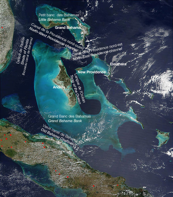
Old Bahama Channel
Fourteen miles. That is all that separates Cuba from the Great Bahama Bank at the narrowest point of the Old Bahama Channel - a gap so slim that on a clear day, shallow Bahamian waters glow turquoise on one horizon while Cuba's green coast holds the other. Yet this slender strait shaped the economy of an empire. For centuries, Spanish galleons loaded with silver from Mexico and gold from Peru threaded through this channel on their way home, their captains squinting at low-lying cays and unmarked shoals, knowing that a single navigational error meant coral, wreckage, and a fortune scattered across the seabed. The channel is roughly 100 miles long and runs between Cuba's northern coast and the southern edge of the Great Bahama Bank, connecting on its western end to the Straits of Florida through two branching arms. It is not dramatic scenery. It is not a tourist destination. It is a gap in the map where history happened because geography demanded it.
The Empire's Bottleneck
In the 1500s, Spanish navigator Alonso Valiente was among those who charted the Old Bahama Channel, mapping a route that would become the jugular vein of Spain's colonial trade. Galleons departing Havana had two choices for reaching the open Atlantic: the Old Bahama Channel to the east, or the Straits of Florida to the north. The Old Bahama Channel was the original preference - a more direct route toward Spain for ships coming from the eastern Caribbean. But the passage was treacherous. The southern Bahama Banks are a labyrinth of shoals, sandbars, and cays that barely break the surface, invisible until a hull scrapes bottom. Ship captains had to pick their way through with leadsmen in the bow, sounding the depth yard by yard. Over time, the trade routes shifted to the Straits of Florida, the so-called New Bahama Channel, which offered deeper water and wider margins for error. The Old Bahama Channel became the road less traveled - not abandoned, but avoided by those who could afford the longer detour.
Shoals and Shipwrecks
The channel has always been hungry for ships. In 1762, a 44-gun Royal Navy vessel wrecked in these waters - one of countless casualties in a passage that punished inattention. The problem is geological: the Great Bahama Bank is essentially a vast underwater plateau, its surface just meters below the waves across thousands of square miles. Where this plateau meets the Old Bahama Channel, the transition is abrupt. Deep blue water gives way to pale shallows with little warning, and what looks like open sea may conceal coral heads hard enough to tear through oak planking.
The cays that dot the channel's northern edge compound the danger. Low, flat, often little more than sand and scrub, they are nearly invisible at sea level until you are upon them. At night or in foul weather, they vanish entirely. Colonial-era charts were unreliable, updated by rumor and bitter experience. Every wreck added another pencil mark to the navigator's mental map, another reef to avoid - assuming anyone survived to report it.
Between Two Worlds
The Old Bahama Channel does not merely separate two landmasses. It divides two geological realities. To the south lies Cuba, a mountainous island resting on a deep oceanic plate, its northern coast fringed by the Sabana-Camaguey Archipelago - a chain of small islands and mangrove cays. To the north rises the Great Bahama Bank, one of the largest carbonate platforms on Earth, a shallow limestone shelf built over millions of years by the accumulated skeletons of coral and marine organisms.
The channel itself is the gap between these two platforms - a trough of deep water cutting through the shallow Caribbean. At its narrowest, between the 22nd and 23rd parallels north, the width rarely exceeds 12 miles. The western end connects to the Straits of Florida via two arms that enclose Cay Sal Bank: the Santaren Channel to the north and the Nicholas Channel to the south. The eastern end is less clearly defined - it can be considered to terminate between Cape Maysi in Cuba and Inagua in the Bahamas, or it can be extended all the way to the Mona Passage between Hispaniola and Puerto Rico.
A Corridor of Current and Wind
From altitude, the Old Bahama Channel reveals itself as a ribbon of deep indigo sandwiched between two expanses of pale aquamarine. The color difference is geology made visible: deep water over the channel's trough, shallow water over the banks flanking it. Cuba's coast runs along the southern edge, its shoreline broken by the low islands of the Sabana-Camaguey chain. The Bahamas sprawl to the north, their shallows extending for miles in every direction, dotted with cays so small they look like flecks of sand dropped on glass.
The channel still carries traffic, though container ships and tankers have replaced galleons. Modern navigation has tamed the shoals that terrified colonial pilots, but the geography remains unchanged: a narrow corridor where deep water permits passage between two vast shallows. Currents push through the channel from east to west, feeding into the Gulf Stream system that carries warm Caribbean water north along the American coast. What was once an empire's highway is now a link in the planet's circulatory system, moving water and warmth from the tropics toward the North Atlantic.
From the Air
Located at 22.77N, 78.40W between Cuba's north coast and the Great Bahama Bank. The channel runs roughly 100 miles east-west and is strikingly visible from cruising altitude as a band of deep blue water between two expanses of turquoise shallows. The color contrast between the deep channel and the shallow banks is one of the most dramatic water-color transitions visible from the air in the Caribbean. No airports directly on the channel, but Jardines del Rey Airport (MUJR) on Cayo Coco lies near the channel's southern shore. To the northwest, the channel branches into the Santaren and Nicholas channels flanking Cay Sal Bank. Best viewed at 25,000-35,000 feet for the full geological perspective. Weather is generally clear but watch for afternoon convective buildups, particularly in summer months.