Old City of Luoyang
Fifteen kilometers east of modern Luoyang lies a ghost city spanning 75 square kilometers -- ten kilometers from east to west, seven and a half from north to south. It is not one city but many, layered atop each other across a thousand years of imperial history. The Han built their eastern capital here. The Northern Wei made it the seat of their dynasty. Emperor Yang of Sui rebuilt it in 605 AD. Today, the Old City of Luoyang is a UNESCO World Heritage Site, part of the Silk Roads corridor designation that recognizes its role as a terminus for trade routes reaching from China to Central Asia.
Capitals Stacked Like Chapters
The existing structure and layout of the Old City dates primarily to the Northern Wei dynasty, which moved its capital here from Datong in 494 AD. But the ground beneath those walls holds far older secrets. The Eastern Han established Luoyang as their capital in 25 AD, and the city served successive dynasties through the Wei, Jin, and into the Northern Wei period. Each new regime built over or alongside what came before, creating a palimpsest of imperial ambition. The site was protected as a Major National Historical and Cultural Site as early as 1961, and received its UNESCO World Cultural Heritage designation in 2014 as part of the broader Silk Roads: the Routes Network of Chang'an-Tianshan Corridor.
What the Ground Remembers
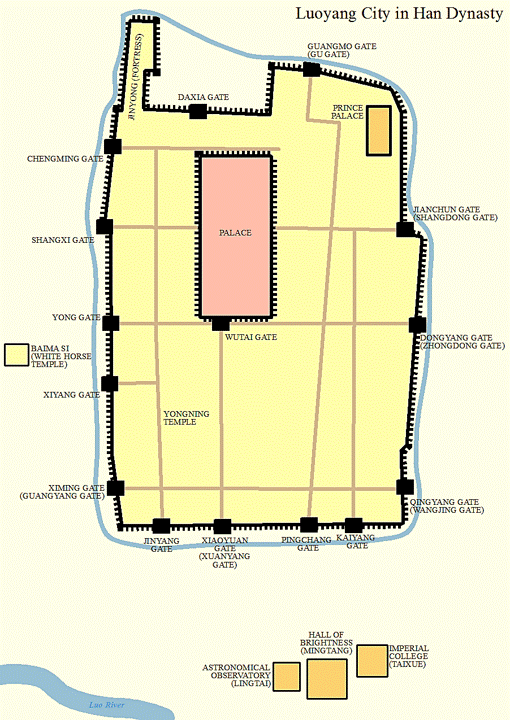
Archaeological excavations have revealed a remarkable catalog of ruins. The Northern Wei inner city wall -- also the wall of the earlier Han, Wei, and Jin capital -- still traces its outline across the landscape. Beyond it lies the outer Guocheng City of the Northern Wei, with its own walls and gate structures. Within and around these fortifications, archaeologists have identified the foundations of Gongcheng, the imperial palace compound, the Jinyong fortress, the Taiji Hall where emperors held court, and the Changhe Gate. The Taixue, the imperial academy of the Eastern Han, has been located, along with the Mingtang ceremonial hall, the Biyong circular moat complex used for ritual purposes, and the Lingtai observatory. Cemeteries from the Eastern Han and Northern Wei periods have yielded ceramics, clay statues, iron implements, copper coins, and gold and silver wares.
The Yongning Temple Tower
Among the most evocative ruins is the foundation of the Yongning Temple and its legendary tower, built during the Northern Wei in 516 AD. The tower, a timber-frame pagoda that may have reached as high as 137 meters or more, was reportedly visible from 50 kilometers away. It was among the tallest structures in the world during its brief existence before lightning struck it in 534 AD, starting a fire that reduced it to its rammed-earth base. That base, with its square foundation measuring 38.2 meters across, still lies within the Old City site -- a reminder of how much ambition once towered above these now-quiet fields.
A Silk Road Anchor
The Old City's inclusion in the UNESCO Silk Roads designation recognizes what its builders always understood: this was not merely a capital but a node in a network. Luoyang sat at the eastern end of trade routes that carried silk, spices, ideas, and religions across Central Asia. Buddhism entered China through cities like this one, and the concentration of temples and monasteries within the Old City walls testifies to that transmission. Today, the site reads from the air as a vast expanse of agricultural land punctuated by wall remnants and excavation zones, its scale almost incomprehensible until you realize that this single archaeological zone encompasses the capitals of multiple dynasties, each of which considered itself the center of the civilized world.
From the Air
Located at 34.72°N, 112.62°E, approximately 15 km east of modern Luoyang, Henan Province. The site covers roughly 75 square kilometers of mostly agricultural land, with remnant walls and archaeological excavation areas visible from low altitude. Nearest airport is Luoyang Beijiao Airport (ZHLY/LYA), about 15 km to the west. Zhengzhou Xinzheng International (ZHCC/CGO) is approximately 140 km east. Altitude recommendation: 3,000-6,000 feet AGL to appreciate the enormous scale of the ancient city footprint. The Luo River runs to the south, and the site occupies flat terrain between the river and low hills to the north.