Old Mariscal Sucre International Airport
Pilots who flew into Quito's old Mariscal Sucre International Airport called it white-knuckle. The airport sat at 2,800 meters above sea level - one of the highest in the world - surrounded by active volcanoes, in the middle of a residential city of more than two million people. Runway 35 ended at a major avenue. Behind the avenue sat apartment blocks. Pichincha volcano rose to the west, Cotopaxi and Antisana to the southeast. On a clear morning the views from final approach were spectacular. On a foggy afternoon, they were terrifying. When the airport closed on the evening of February 19, 2013, there were pilots around the world who breathed a sigh of relief.
A Runway in a Bowl
Mariscal Sucre International Airport opened on August 5, 1960, on the northern edge of Quito in what was then the Chaupicruz parish. The main terminal was built during the second presidency of Jose Maria Velasco Ibarra. The name honored Antonio Jose de Sucre, the Venezuelan-born general who had won the Battle of Pichincha in 1822, ending Spanish rule in what is now Ecuador. In its final years the airport handled about 6.2 million passengers and 164,000 metric tons of freight annually. The state airline TAME used Mariscal Sucre as its primary hub, operating around 50 departures daily. The problem was never traffic volume. The problem was topography. Quito sits in a long, narrow valley at high altitude. The Andes rise steeply on every side. Expanding the airport was impossible. Modifying the approach paths was impossible. Pilots had to work with what the valley allowed.
The First Crash
On November 7, 1960 - three months after the airport opened - an AREA Ecuador Fairchild F-27A struck the dormant Atacazo volcano in bad weather while on approach from Guayaquil. The aircraft was the first production F-27 ever built, serial number one, sold to AREA the previous year. All 37 people on board were killed. The crash site, 16 kilometers south of Quito, was 150 meters below the summit. It was the worst aviation accident in Ecuadorian history to that point, the first and worst fatal loss of an F-27 globally, and the first serious accident at the brand-new airport. The investigation pointed to problems that would recur over the next half century: weather, terrain, altitude, and the narrow margins a mountain airport provides.
Cubana 389
On August 29, 1998, a Cubana de Aviacion Tupolev Tu-154M overshot the runway during a failed takeoff. The aircraft had been heavily loaded and could not achieve sufficient speed. It ran off the end of runway 35 and through a residential neighborhood. Fourteen crew members and 56 of the 77 passengers died inside the aircraft. Ten more people died on the ground. The 80 deaths made Cubana 389 the deadliest accident in the airport's history and one of the worst aviation disasters in Ecuadorian history. In response, authorities built a runway safety area - a horizontal berm 280 meters long and 92 meters wide - at the start of runway 17. It required expropriating private and public property and building a two-way tunnel under the platform for vehicle traffic on Tufino Avenue. The safety zone was inaugurated in mid-July 2000. It saved lives in subsequent incidents. It could not address the fundamental problem.
A Catalog of Near-Misses
Between 1980 and 2013, the airport saw a litany of accidents and close calls. In 1980, an Avianca Boeing 727 overran the runway, collapsing its nose gear. In 1982, a Lockheed C-130 Hercules of the Ecuadorian Air Force crashed into a mountain during a missed approach, killing seven. In 1984, an AECA Douglas DC-8 freighter failed to gain altitude on takeoff, crashing into 25 houses beyond the runway and killing 4 crew and 49 people on the ground. In 1995, a Gulfstream II bound from Buenos Aires via La Paz struck the Sincholagua volcano when its pilot selected the wrong VOR frequency; seven oil executives died. In 2007, an Iberia Airbus A340-600 slid off runway 35 into the newly built safety zone - the landing gear collapsed and two engines were dislodged, but all 333 people aboard survived. In April 2005, protesters breached the airport perimeter to block the runway, preventing President Lucio Gutierrez from fleeing the country during the Ecuadorian popular revolt. Each incident added pressure to move the airport.
The Transition and the Park
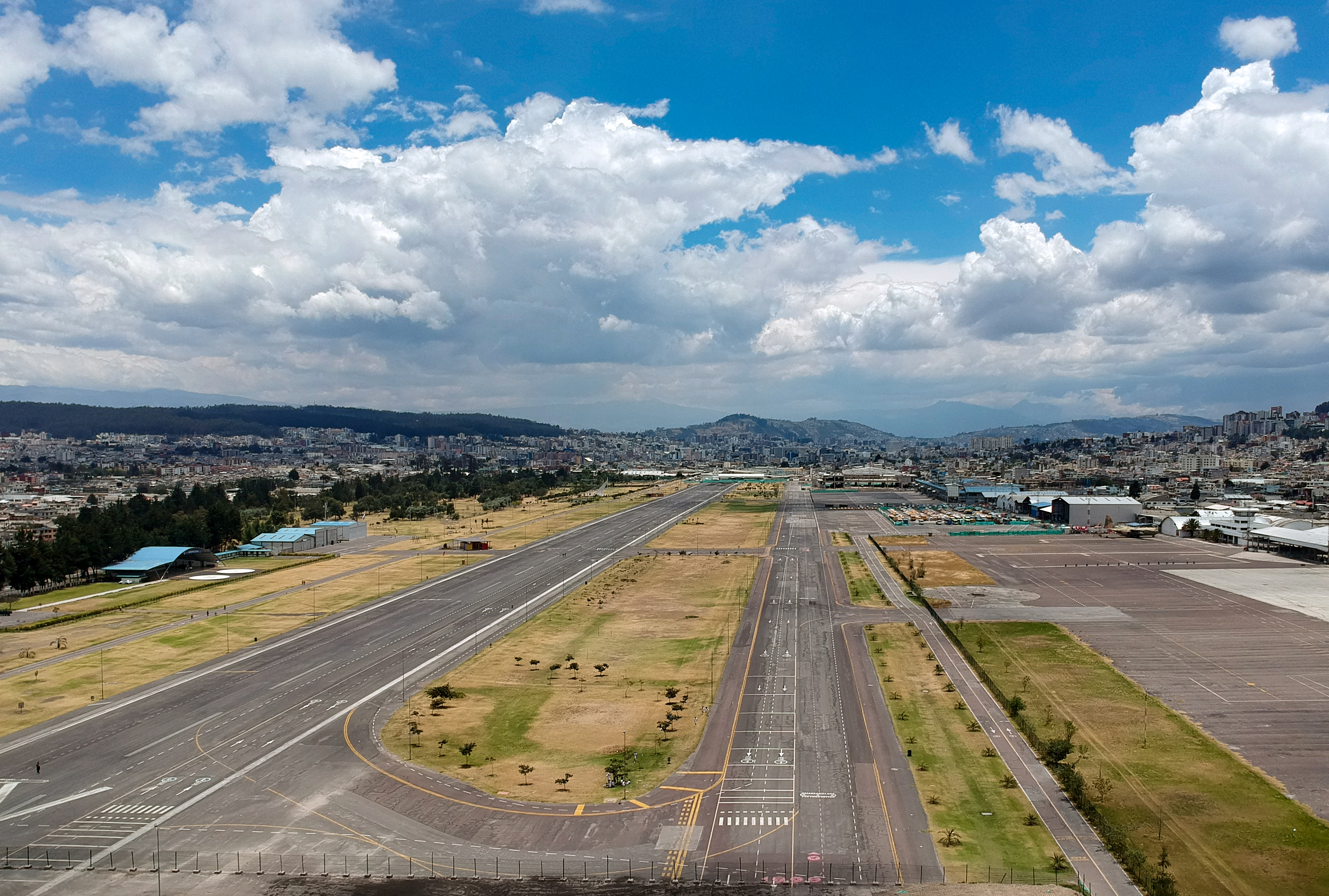
The final TAME flight departed Mariscal Sucre at 19:00 on February 19, 2013 - Flight 321 to Guayaquil, scheduled for 18:55 and delayed five minutes. Iberia operated the final international departure. On the morning of February 20, all operations shifted to a new airport 18 kilometers east of Quito in the Tababela parish, keeping the Mariscal Sucre name. TAME Flight 302 from Guayaquil and LAN Flight 2590 from Lima were the first arrivals at the new facility. The old airport site in Chaupicruz did not sit empty. It became Parque Bicentenario, the largest urban park in Quito - more than 130 hectares of open green space where the runway once ran. The tarmac has been converted to walking paths and bike lanes. Children play where aircraft once touched down. The Andes still rise on every side. The volcanoes are still there. But no airplane will ever take off into that valley again.
From the Air
Located at 0.14 degrees S, 78.49 degrees W at 2,800 meters elevation. The former airport is now Parque Bicentenario, located in the north-central section of Quito. The new Mariscal Sucre International Airport (SEQM) operates 18 km east in Tababela. From altitude, the old site is visible as a long green rectangle running north-south within the urban fabric of Quito. Pichincha volcano dominates the western skyline; Cotopaxi is a distant cone to the southeast on clear days. Thin mountain air and unpredictable weather remain the defining features of flying over Quito.