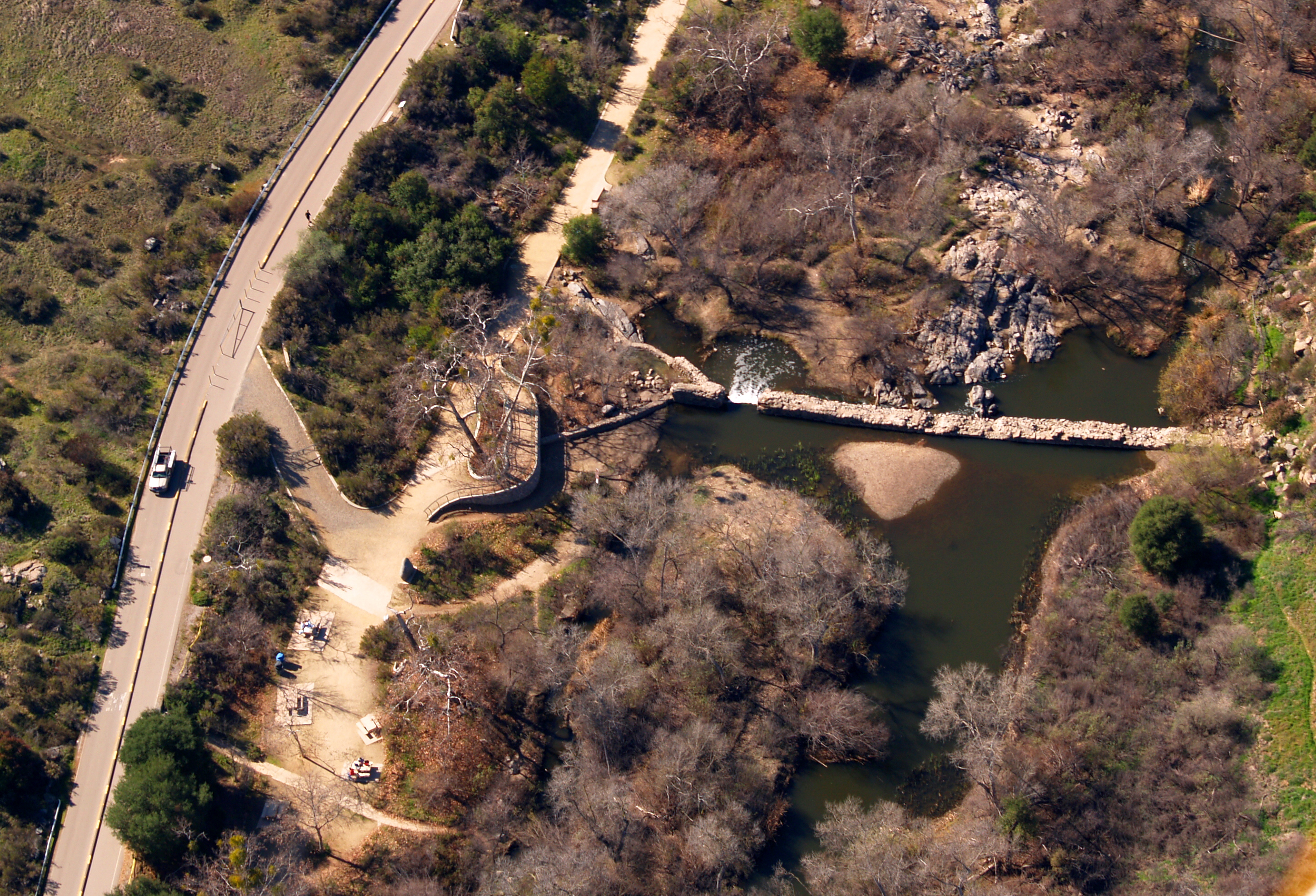
Old Mission Dam
The Spanish called it El Presa de la Misión — the dam of the mission. It was built in 1803 by Christianized Native Americans working under the direction of Franciscan friars at Mission San Diego de Alcalá, six miles to the west. The dam impounded the San Diego River and redirected its water through an aqueduct to irrigate the mission's fields. It was the first major colonial-era irrigation project on the Pacific coast of what is now the United States. Two centuries later it is still there, a stone structure in a canyon inside Mission Trails Regional Park, a National Historic Landmark that you can walk to on a flat trail from the Visitor Center.
Why the Dam Was Built
Mission San Diego de Alcalá was established in 1769, the first of the California missions, founded by Father Junípero Serra. By 1800 the mission had baptized approximately 1,500 Native Americans — a number that reflected both the Franciscan program of conversion and the devastating population losses to European diseases that made surviving indigenous people more vulnerable to the mission system's gravitational pull. Feeding a community of that size required agricultural output that the mission's existing water supply could not reliably support. Between 1800 and 1802, a three-year drought made the problem acute. The decision to build a permanent dam and aqueduct system was practical: without reliable irrigation, the mission's agricultural foundation would fail.
The Labor and the Structure
The dam was built between 1803 and 1816, reaching its greatest extent in 1817. The workers who built it were Kumeyaay people who had converted to Christianity and were living at the mission — people whose traditional relationship to the San Diego River and its watershed predated the mission by thousands of years and who were now reshaping that landscape under a colonial directive. The dam is constructed of stone with a clay core; it stands in the river canyon at the point where the gorge narrows, which is where a dam makes structural sense. An aqueduct carried water from the impoundment westward toward the mission fields. The system was functional for several decades before falling into disuse as the mission era ended.
Rediscovery and Recognition
The dam was reported as ruins in 1867, when enough time had passed since the mission's secularization that the infrastructure it had built was no longer being maintained. Someone repaired it in 1874 — who and for what purpose the record does not make entirely clear. By the twentieth century it was a recognized historical artifact, and in 1933 it was designated a State Historical Landmark by California. Federal recognition as a National Historic Landmark followed, acknowledging that the dam's significance extended beyond California: it was the oldest known surviving example of European-style water management infrastructure on the Pacific coast of North America.
The Dam Today
Old Mission Dam sits inside Mission Trails Regional Park, accessible by a flat 1.5-mile trail from the Visitor Center along the San Diego River. The setting is quieter than most people expect: a river canyon with riparian vegetation, birds using the water, the stone dam visible as a weathered curve across the flow. The structure no longer serves a water management function — the San Diego River's water is managed by infrastructure built in subsequent centuries — but it remains physically intact, which is itself an engineering accomplishment. Stone dams built with colonial-era techniques and mission labor, maintained for two centuries by geography and protected status, are not common. This one survives.
From the Air
Old Mission Dam is located at approximately 32.840°N, 117.043°W in the Mission Gorge section of Mission Trails Regional Park in eastern San Diego. The dam is in the San Diego River canyon; the gorge is identifiable from the air as a narrow cut through the plateau. Mission Trails Visitor Center is nearby to the south. Nearest airports: KMYF (Montgomery-Gibbs Executive) 5 miles northwest, KSAN (San Diego International) 11 miles west. Best viewed at 2,000–3,000 feet MSL; the river canyon is visible as a dark vegetated line through the surrounding terrain.