Old Mobile Site
Twenty-three young women, sick with yellow fever after a harrowing Atlantic crossing, stepped off the ship Pelican onto the muddy banks of the Mobile River in 1704. They had been recruited from French orphanages and convents, promised husbands and a new life in Louisiana. What they found instead was a primitive wooden fort surrounded by swamp, a settlement already struggling to feed itself, and cornbread instead of the French bread they craved. These "casquette girls" -- named for the small trunks they carried -- had arrived at La Mobile, the first capital of French Louisiana and France's answer to England's Jamestown. The site, now buried in the Mobile-Tensaw River Delta near the community of Le Moyne, Alabama, was home to Fort Louis de La Louisiane from 1702 until a catastrophic flood forced its abandonment in 1711.
A Continent Up for Grabs
The founding of La Mobile was an act of imperial strategy. After the Spanish Armada's defeat in 1588 weakened Spain's grip on the New World, France and England raced to claim the interior of North America. In 1682, La Salle had floated down the Mississippi and claimed the entire basin for Louis XIV. But claims on paper meant nothing without boots on the ground. France needed a fort on the Gulf of Mexico to protect the Mississippi, counter English expansion from the Eastern Seaboard, and lock down the lucrative fur trade with Native peoples. By controlling a chain from Canada through the Ohio Valley to the Gulf Coast, France could encircle the English colonies entirely. The stakes were enormous -- not just territory, but the economic engine of an entire continent's interior. Mobile was the southern anchor of that grand design.
The Le Moyne Brothers
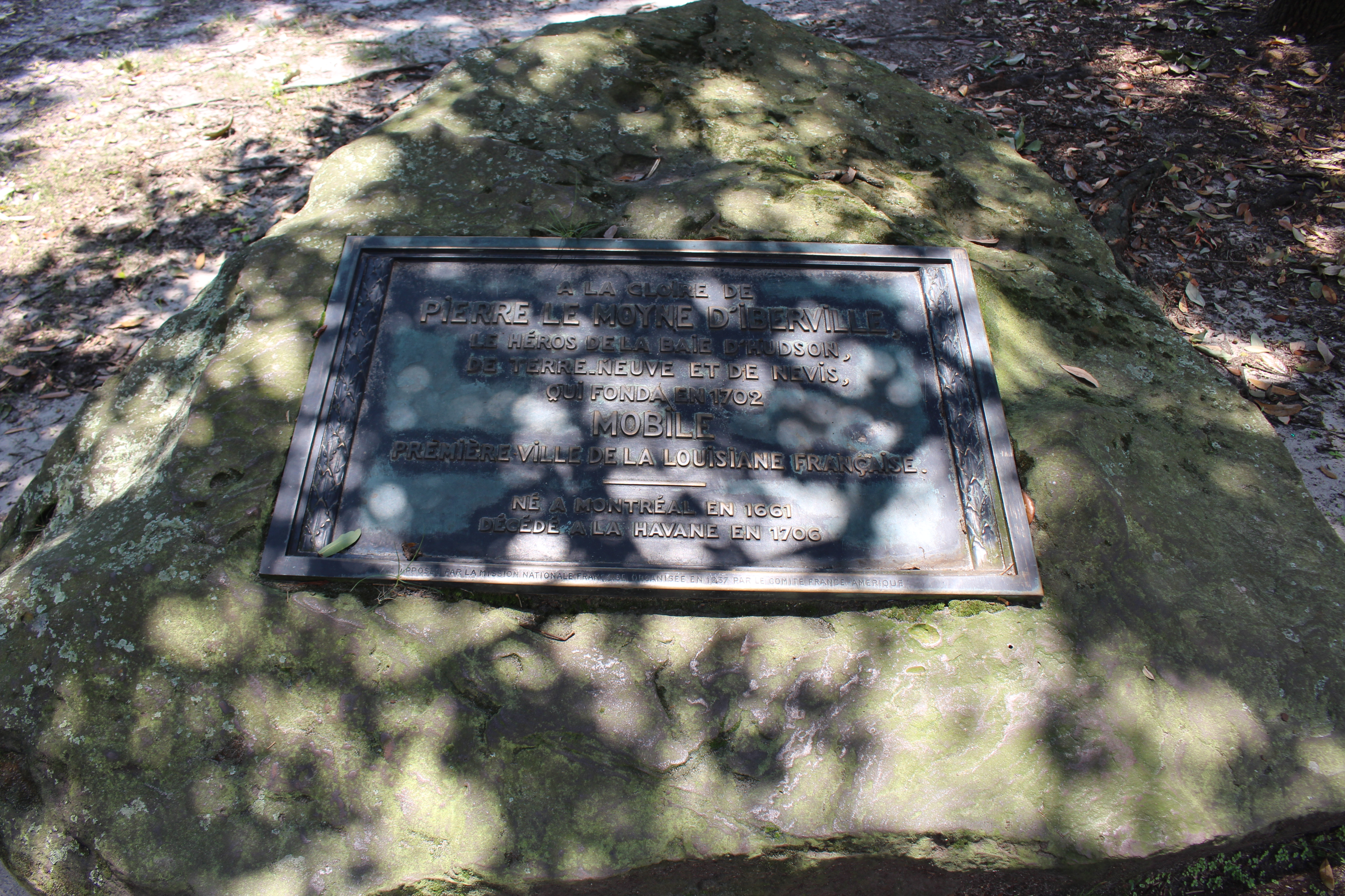
Pierre Le Moyne d'Iberville, born in Montreal to a French emigrant family, was a war hero of King William's War who had attacked English positions in North America with devastating effectiveness. His seamanship and ferocity made him the natural choice to lead the Gulf expedition. On January 31, 1702, the French anchored at the mouth of the Mobile River and began scouting for a fort location. Iberville selected a ridge at Twenty-Seven Mile Bluff, more than twenty feet above the water, wooded with oak, pine, sassafras, and hickory. Construction began immediately. When Iberville died, governance passed to his younger brother, Jean-Baptiste Le Moyne de Bienville, an energetic leader who spoke Native languages and built alliances with local tribes. Two more Le Moyne brothers -- Joseph de Serigny and Antoine de Chateaugue -- helped defend the settlement against English and Spanish attacks. La Mobile was, in many ways, a family enterprise.
Life Inside the Palisade
A 1704 census paints a vivid picture: 180 men, 27 families with ten children, eleven Native American slave children, a guardhouse, a forge, a gunsmith shop, a brick kiln, and eighty one-story wooden houses. The square fort had cannons at each corner and enclosed quarters for officers, a chapel, and a warehouse. Behind the fort, the village was laid out in a grid. By 1708, the settlement kept 8 oxen, 4 bulls, 50 cows, 40 calves, roughly 1,400 pigs, and some 2,000 chickens. But survival was precarious. The coureurs de bois from Canada refused to farm. Supply ships from France stopped coming for three years during the War of the Spanish Succession. The colonists resorted to hunting, fishing, and even buying food from the Spanish in Pensacola. Without the knowledge of Native women -- who taught the French how to prepare local ingredients -- the colony would almost certainly have failed.
Drowned and Burned
Complaints about the site mounted. The land drained poorly, with standing water lingering for weeks after each rain. The settlement sat too far from Mobile Bay for practical access. Then, in the spring of 1711, the river settled the argument. A massive flood rushed into Fort Louis, submerging houses to their rooftops for nearly a month. Soldiers and citizens scrambled into the trees to survive. Bienville chose a new location where the river meets the bay and surveyed the town that would become present-day Mobile. For years, historians assumed the colonists dismantled the old buildings and floated the timber downstream. But archaeological excavations that began in 1989 under Gregory A. Waselkov of the University of South Alabama revealed a different story: every excavated structure had been burned in place. The old settlement was not abandoned gently. It was destroyed.
Unearthing La Mobile
The site lay forgotten for centuries. In the 1970s, a group of industrial workers led by James C. "Buddy" Parnell formed the Old Mobile Research Team and, using aerial photographs and French colonial maps, located the true settlement in February 1989. Previous searchers had been digging in the wrong spot. Formal excavations beginning in June 1989 recovered thousands of artifacts: a lead seal dated 1701 stamped with a fleur-de-lis and the name of the Company of Indies of France, fragments of dinnerware, clay pipe stems, iron cannonballs, and bricks. Nine structures have been fully excavated, revealing construction techniques -- poteaux-en-terre, poteaux-sur-sole, and piece-sur-piece -- that represent some of the earliest European building methods used on the Gulf Coast. The site was listed on the National Register of Historic Places in 1976 and later determined eligible for designation as a National Historic Landmark. Beneath the Alabama mud, the first capital of French Louisiana had been waiting.
From the Air
Located at 30.97N, 88.00W in Le Moyne, Alabama, on the Mobile River within the Mobile-Tensaw River Delta. The site lies approximately 30 miles north of the present-day city of Mobile. Nearest major airport is Mobile Regional Airport (KMOB), roughly 30 nm to the south. From altitude, the area presents as flat river-delta terrain with extensive wetlands and winding waterways. The archaeological site itself is not visible from the air, but the broad Mobile River and delta landscape provide strong visual references. Mobile Bay is visible to the south. Best viewed at lower altitudes where the river channel and surrounding terrain details become apparent.