Old River Control Structure
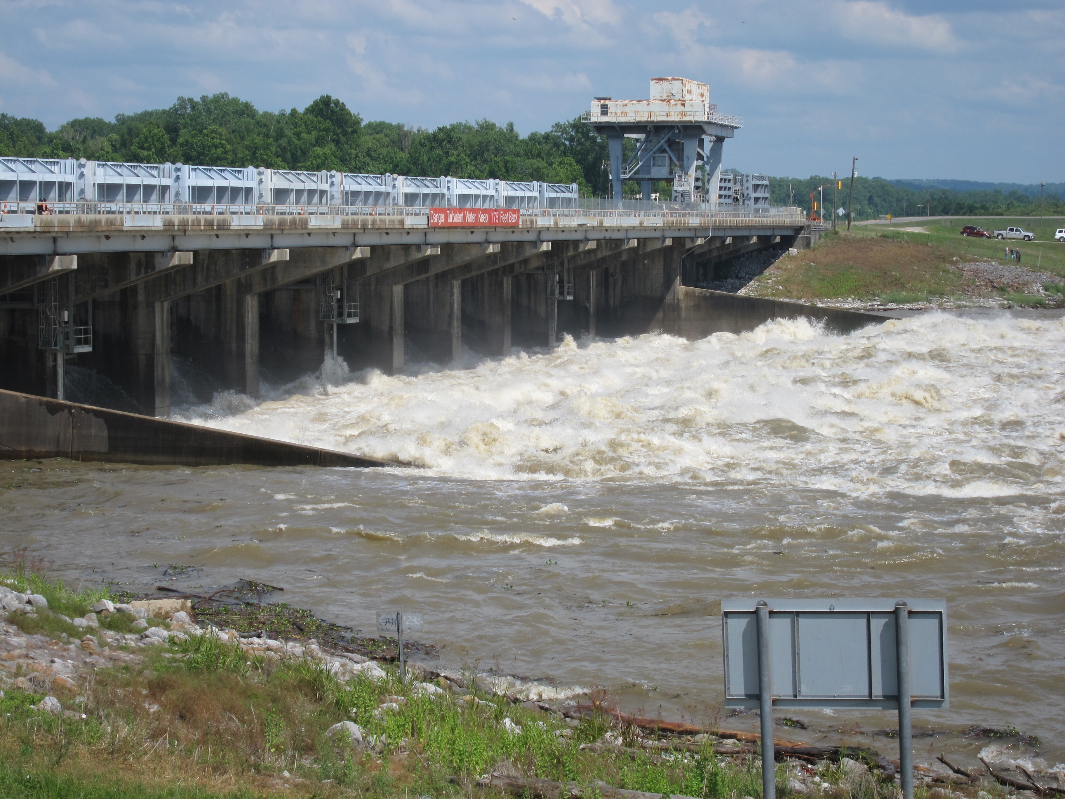
Somewhere in the swampy lowlands of central Louisiana, a set of concrete gates holds the economic fate of two major American cities. The Old River Control Structure does not look like much from the air -- a few gray slabs straddling muddy channels between the Mississippi and the Atchafalaya rivers. But this unassuming complex, completed in 1963 by the U.S. Army Corps of Engineers, performs one of the most audacious feats of engineering on the planet: it prevents the Mississippi River from changing course. Without it, the river would have long since abandoned its channel through Baton Rouge and New Orleans, rerouting itself down the shorter, steeper path of the Atchafalaya to the Gulf of Mexico. The cities would lose their freshwater supply, their port traffic, their industrial base. As meteorologist Jeff Masters once put it, failure of this complex "would be a serious blow to the U.S. economy."
A River That Wants to Move
Rivers are restless things. The Mississippi has changed course roughly every thousand years throughout its geological history, and by the mid-twentieth century, it was overdue. The trouble began centuries earlier, when the Mississippi's meandering created an oxbow loop called Turnbull's Bend near present-day Angola, Louisiana. In the fifteenth century, this loop intersected the Red River, birthing a new distributary: the Atchafalaya. At first the connection was modest, but in 1839, locals removed a massive natural log jam called the Great Raft from the Atchafalaya, and the balance of power between the two rivers began to shift. By 1880, the Atchafalaya was capturing an ever-growing share of the Mississippi's flow. The shorter, steeper route to the Gulf was winning. Left unchecked, the Mississippi would have fully redirected itself into the Atchafalaya Basin, creating a new delta south of Morgan City and leaving New Orleans stranded on a sluggish backwater.
Concrete Against Gravity
Congress directed the Army Corps of Engineers to intervene, and in 1963 the Old River Control Structure became operational. Its mandate was deceptively simple: maintain a 70-30 split, sending seventy percent of the combined flow of the Mississippi and Red rivers down the Mississippi's existing channel and thirty percent down the Atchafalaya. The original complex included a low-sill structure for routine flow regulation and an overbank structure activated only when the Mississippi exceeded its banks. A navigation lock allowed barge traffic to pass between the rivers. The system worked -- until the Mississippi flood of 1973 nearly destroyed it. Floodwaters scoured the foundations of the low-sill structure, and for a harrowing period, engineers feared the entire complex would fail. It held, barely, but the close call prompted construction of the Old River Control Auxiliary Structure in 1986 to share the load during future floods.
The Stakes Beneath the Surface
What makes the Old River Control Structure so consequential is not the engineering itself but what lies downstream. Baton Rouge and New Orleans depend on the Mississippi for drinking water, industrial cooling, and the navigation channel that makes them among the busiest port complexes in the world. A diversion would strand petrochemical plants, grain elevators, and shipping terminals along a hundred miles of river. The Atchafalaya route would flood communities around Morgan City. The economic disruption would ripple across the country. And yet the river pushes relentlessly against its concrete restraints. Each spring flood tests the structure anew. The Sidney A. Murray Jr. Hydroelectric Station, completed in 1990 as the newest component, generates power while providing an additional measure of flow control. The nearby Morganza Spillway serves as a safety valve, though it has been opened only twice since the control structure was built.
Holding the Line
From the air, the Old River Control Structure reveals its true scale. Three separate dam structures span channels between the Mississippi's main flow and the Atchafalaya, with Concordia Parish, Louisiana, on one side and Wilkinson County, Mississippi, on the other. The landscape is a maze of levees, spillways, and diversion channels -- the visible architecture of humanity's attempt to dictate terms to the continent's greatest river. Some researchers believe the likelihood of a catastrophic course change increases each year despite these artificial controls. The Mississippi, after all, has been rearranging the geography of the Gulf Coast for millennia. The Old River Control Structure is a bet -- an enormous, expensive, constantly maintained bet -- that human engineering can hold a river in place indefinitely. So far, the bet has paid off. But the river is patient.
From the Air
Located at 31.0768N, 91.5979W in central Louisiana where the Mississippi and Atchafalaya rivers diverge. From the air, look for three dam structures spanning side channels west of the Mississippi's main flow. Best viewed at 2,000-4,000 feet AGL. The complex is between Concordia Parish (LA) and Wilkinson County (MS). Nearest airports: Concordia Parish Airport (0R4) in Vidalia, LA, approximately 30 nm south; Alexandria International Airport (KAEX) approximately 74 nm northwest. The Morganza Spillway is visible about 30 nm to the south along the Mississippi.