Olympic Peninsula
Rain falls here like nowhere else in the continental United States - up to 200 inches per year in the valleys that radiate from the Olympic Mountains. The result is a landscape out of time: temperate rainforests where Sitka spruces draped in moss reach 300 feet toward fog-shrouded skies, where Roosevelt elk move through cathedral groves, where rivers run milky with glacial flour from peaks that catch every Pacific storm. The Olympic Peninsula is an island of wilderness surrounded by water on three sides and civilization on the fourth, a place where you can stand in primeval forest and see Seattle's downtown towers shimmering across Puget Sound.
The Rainforest Valleys
The Hoh, Quinault, and Queets rainforests receive more precipitation than almost anywhere in North America. The effect is overwhelming. Every surface grows something: moss blankets tree trunks and fallen logs, ferns cascade from branches, lichens hang like curtains. The air tastes green. Light filters through the canopy in shafts, illuminating nurse logs where new generations of trees take root on their fallen ancestors.
Sitka spruce and western red cedar dominate the overstory, some trees over 1,000 years old, their trunks too large for a dozen people to encircle. Roosevelt elk - the largest subspecies of elk in North America - graze the riverbanks and meadows, their bugling echoing through the valleys in autumn. The forest floor is a maze of sword ferns and oxalis, the understory so thick in places that you could walk ten feet from the trail and vanish entirely.
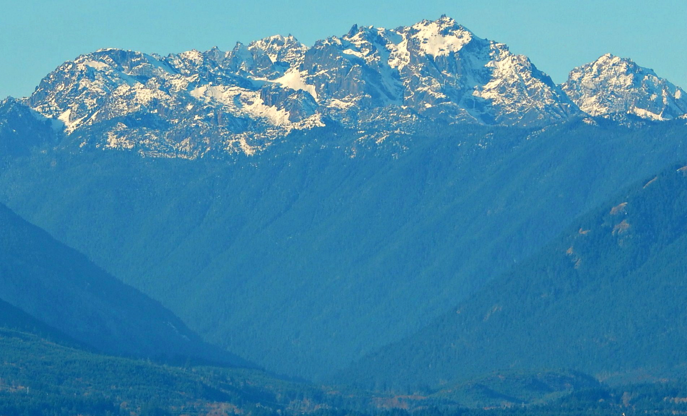
The High Olympics
The Olympic Mountains rose from the seafloor. Millions of years of subduction pushed marine sediments upward until they towered nearly 8,000 feet above sea level - young mountains, still sharp-edged, still heavily glaciated. Mount Olympus, at 7,980 feet, carries seven glaciers despite its modest height, fed by the same storms that drench the rainforests below.
Above treeline, the Olympics turn alpine: meadows of wildflowers, marmots whistling from boulder fields, mountain goats traversing impossibly steep rock faces. The views stretch from Mount Rainier to the east to the Pacific Ocean to the west. The contrast is disorienting: you can see the most densely populated region of the Pacific Northwest in one direction and true wilderness in every other. The park has no roads through its interior - only trails that require days of hiking to reach its heart.
The Wild Coast
The Pacific edge of the peninsula remains as wild as any coastline in the lower 48. Sixty miles of beach are protected within Olympic National Park - sea stacks and headlands, tide pools teeming with life, beaches accessible only by hiking through forest. The coastline is shaped by violence: winter storms drive thirty-foot waves against basalt cliffs, carving sea caves and throwing driftwood logs the size of houses into piles above the high-tide line.
Shipwrecks dot the coast, earning it the name 'Graveyard of the Pacific.' Point of the Arches, Shi Shi Beach, Rialto Beach - these names appear on bucket lists of wilderness seekers. At low tide, the tide pools reveal universes in miniature: purple sea urchins, orange sea stars, green anemones, chitons clinging to rocks that will be submerged hours later. Bald eagles patrol the strand. Seals watch from offshore rocks. The only sounds are waves and wind and the occasional cry of a gull.
Rivers of Salmon
The rivers that drain the Olympics are salmon rivers, carrying five species of Pacific salmon from the ocean to their spawning grounds. The Elwha, recently freed from two dams, is recovering its wild runs. The Hoh runs thick with fish in autumn. These salmon are keystone species, carrying marine nutrients deep into the forest when they spawn and die, feeding bears and eagles and eventually the very trees that shade the streams.
Standing on a riverbank in October, you can watch the cycle unfold: bright coho salmon holding in pools, their bodies already darkening as they near death, ravens and eagles waiting in streamside trees, the water carrying the scent of decomposition and renewal. The forests are fertilized by the sea, connected to the Pacific through the bodies of fish that make the journey once and never return.
The Rain Shadow
Not all of the Olympic Peninsula is wet. The northeast corner lies in the rain shadow of the mountains, receiving less rainfall than Los Angeles. Sequim, tucked behind the peaks, averages just 16 inches per year while the Hoh Rainforest, 40 miles away, gets over 140 inches. Lavender farms thrive in the dry sunshine. Madrone trees shed their red bark on slopes above the Strait of Juan de Fuca.
This rain shadow creates the peninsula's remarkable diversity. In a single day, you can walk through dripping rainforest, climb to alpine glaciers, descend to windswept Pacific beaches, and finish in sunny oak woodlands - four distinct ecosystems shaped by the same mountains that block or capture Pacific moisture. It's a compression of landscapes found nowhere else, a reminder that the Pacific Northwest is not one place but many, layered and complex, each valley its own world.
From the Air
Located at 47.8°N, 123.6°W. The Olympic Peninsula is a distinct landmass bounded by Puget Sound to the east, the Strait of Juan de Fuca to the north, and the Pacific Ocean to the west. The Olympic Mountains are clearly visible - a compact range with extensive glaciation on Mount Olympus (7,980 ft) and surrounding peaks. The contrast between dark green rainforest valleys (especially the Hoh, Quinault, Queets) and alpine peaks is striking. The wild Pacific coastline shows sea stacks and rugged headlands. Lake Crescent appears as a deep blue crescent in the northern foothills. Nearest airports: Fairchild International (KCLM) at Port Angeles, Seattle-Tacoma International (KSEA) 65nm east. Frequent low clouds and fog on the coast; the rain shadow on the northeast peninsula often has better conditions.