Oorlogskloof Nature Reserve
The name means "war gorge," and the war it remembers happened in 1739 -- a battle between indigenous Khoi people and local farmers that left its mark not on the landscape but on the language. Oorlogskloof, 10 kilometers south of Nieuwoudtville in the Northern Cape, is a nature reserve of 4,776 hectares where the Oorlogskloof River has cut a deep gorge through mountainous terrain, creating a landscape of waterfalls, natural pools, and sandstone caves that hold rock art from centuries of human habitation. The violence that named it has long passed. What remains is one of the Western Cape's most rewarding wilderness areas.
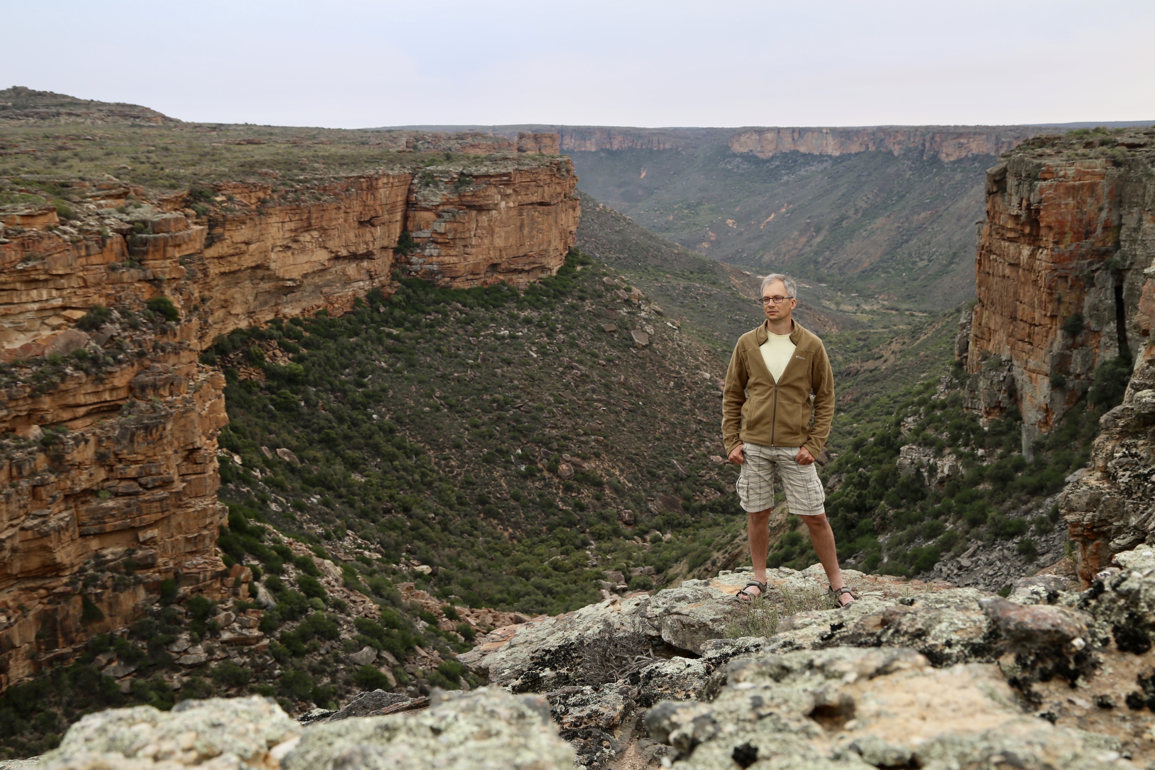
Carved by Water, Named by Conflict
The Oorlogskloof River gorge runs along the eastern border of the reserve, and from it, numerous streams branch into the mountainous interior. The terrain is deeply dissected -- gorges cutting through sandstone plateaus, creating 36 natural pools and waterfalls scattered throughout the reserve. The western boundary abuts the Knersvlakte, the quartz-strewn plain whose ecology could not be more different from the lush gorge systems of Oorlogskloof. The contrast is sharp: on one side, arid plains where tiny succulents cling to white gravel; on the other, shaded ravines where water has carved swimming holes into the bedrock. The 1739 conflict between Khoi people and colonial farmers gave the gorge its Afrikaans name, but the caves along the plateau edges hold evidence of far older human presence -- rock art that predates the colonial era by centuries, recording the lives of San communities who knew this landscape intimately.
From Battle Ground to Protected Ground
The reserve was declared in 1971, formalizing protections for a landscape that had already been shaped by centuries of human activity. In 2012, the Department of Environmental Affairs funded a significant upgrade: ten log cabins capable of accommodating 15 people each, solar panels, septic tanks, pedestrian bridges, stream crossings, and three boreholes. The investment also included the removal of alien invasive species -- Black Wattle, Port Jackson, Eucalyptus, and Prosopis -- that had established themselves in the nutrient-rich gorge environment. Invasive species removal is unglamorous conservation work, but in a landscape defined by its indigenous plant communities, it is essential. Every alien tree removed gives native fynbos and Succulent Karoo species a better chance of reclaiming the ground.
Five Days on the Trail
Oorlogskloof is a hiker's reserve. Two day trails -- the 15.5-kilometer Leopard Trap and the 17.9-kilometer Rietvlei -- offer single-day immersions in the gorge landscape. But the reserve's signature experiences are the multi-day routes: the Rock Pigeon Trail at 52.2 kilometers over five days, and the Rameron Pigeon Trail at 52.4 kilometers over four to seven days. Named for the birds that nest in the cliffs, these trails traverse the full range of Oorlogskloof's terrain -- from the river gorge to the plateau tops, through pools that invite swimming and past caves that invite exploration. The log cabins provide overnight shelter, but the scale of the landscape ensures that hikers spend most of their days in deep solitude, moving through a terrain that has changed very little since the people who painted the cave walls walked the same paths.
Where the Karoo Meets the Mountains
Oorlogskloof sits at an ecological crossroads. To the west, the Knersvlakte stretches toward the coast with its quartz fields and endemic succulents. To the east and north, the landscape opens into the semi-arid interior of the Northern Cape. The reserve itself bridges these biomes, hosting a mix of fynbos, Succulent Karoo, and riparian vegetation along its watercourses. Nieuwoudtville, the nearest town, is known as the bulb capital of the world for its spectacular spring wildflower displays. In the right season, the drive south from town to the reserve entrance passes through carpets of color that vanish into the gorge's cooler, greener world. It is a reserve where every turn in the trail brings a change of scene -- from open plateau to shaded ravine, from dry scrub to waterfall, from silence to birdsong -- and where the name on the map remembers a conflict that the landscape itself has quietly outlived.
From the Air
Oorlogskloof Nature Reserve is at approximately 31.45S, 19.15E, about 10 km south of Nieuwoudtville in the Northern Cape. From altitude, the terrain shows deep gorge systems cut into sandstone plateaus, with the Oorlogskloof River gorge along the eastern boundary. The Knersvlakte's pale quartz plains are visible to the west. Nearest town is Nieuwoudtville to the north. Cape Town International (FACT) is approximately 350 km to the south. Caution: mountainous terrain with deep gorges.