Oosterscheldekering
The original plan was simple: build a dam, close the estuary, walk away. After 1953, the Netherlands had decided it would never again lose almost two thousand people to a single storm tide, and the southwestern delta would be sealed against the North Sea once and for all. By the early 1970s, half of the project was done and the Eastern Scheldt was next. Then the Dutch did something unexpected. They listened to oyster farmers and biologists and a generation of protesters who pointed out that a closed estuary is a dead estuary, and they changed the plan in mid-build. The result is the Oosterscheldekering — nine kilometres of barrier with sixty-two giant steel doors that hang open most of the time and slam shut only when the sea is dangerous. It is one of the most consequential engineering compromises of the twentieth century.
The Choice
The Delta Plan, drawn up after 1953, called for an outright dam across the Eastern Scheldt. It would have been faster and cheaper than what was eventually built. It would also have killed the estuary behind it: no tide, no salt water, no oysters, no mussels, no seal haul-outs, no migratory birds in the numbers the shoals had supported for centuries. Fishing communities along the Oosterschelde fought the closure. So did environmental scientists. So did, eventually, the Dutch public. By the early 1970s the political mood had shifted enough that the government re-opened the design. The compromise was a movable barrier — a structure that could be open to the tide most of the time and closed to the surge when the surge came. It cost much more money. It took much more time. It saved the Eastern Scheldt as a living place.
Building It
Construction began in April 1976 and ran until June 1986. The dam rests on 65 prefabricated concrete pillars, each between 35 and 38.75 metres tall and weighing 18,000 tonnes — heavier than many warships. They were cast in a dry dock, then floated out to the estuary by a fleet of four custom ships named after shellfish: Mytilus, which compacted the seabed; Cardium, which laid a special foil mat for the pillars to rest on; Ostrea, an 85-metre giant with a 50-metre portal that lifted the pillars into place; and Macoma, which helped finish the alignment. Between the pillars hang 62 steel sluice doors, each 42 metres wide. Building the entire barrier in the middle of a tidal estuary, on a soft seabed, against a sea that does not pause, was hard enough that the American Society of Civil Engineers later named the Oosterscheldekering one of the modern Seven Wonders of the World.
Zeeland Is Safe
On 4 October 1986, Queen Beatrix stood at the barrier and spoke a line that every Dutch schoolchild now knows: "De stormvloedkering is gesloten. De Deltawerken zijn voltooid. Zeeland is veilig." The flood barrier is closed. The Delta Works are completed. Zeeland is safe. The road over the dam was added later and was inaugurated on 5 November 1987 by Princess Juliana — exactly 457 years to the day after St Felix's Flood of 1530 had washed away the now-lost towns of Reimerswaal, upstream of the new barrier's line. Coincidences like that are not really coincidences in Dutch water history. They are reminders. On a plaque at the Neeltje Jans end of the barrier, eleven words go further than any speech: "Hier gaan over het tij, de maan, de wind en wij." Here, the moon, the wind, and we govern the tide.
How the Doors Work
Most days, the sea flows through the barrier as if it were not there. The 62 doors hang above the channel, the tide rises and falls inside the Eastern Scheldt with only a slight reduction, and the oysters, lobsters, and seals carry on. The doors are closed only when forecast water levels reach at least three metres above the regular sea level. Each gate is tested once a month, and emergency procedures are rehearsed on fixed dates so that no one is surprised when a real storm arrives. Closing a single door takes about an hour. The full barrier has been shut twenty-eight times since 1986, most recently on 31 January 2022 when Storm Corrie threatened the Dutch coast — almost exactly 69 years after the 1953 flood that started this whole story. Operating the system costs about 17 million euros a year, and the structure is designed to last more than two hundred.
Tides, Turbines, and Time
In 2015, engineers mounted five Tocardo T2 tidal turbines on a frame slung from the road bridge in the eighth sluice channel from the southern end. They began feeding the Dutch grid in 2016 and ran for eight years before being decommissioned in 2023 — the largest tidal-power demonstration the country had attempted, and a glimpse of how the next century might harvest the currents the previous century learned to fear. The barrier itself was never about generating electricity. It was about generating safety, and about admitting that safety did not have to mean killing the place you were trying to save. From the air, the Oosterscheldekering reads as a thin pale line stitched across the estuary. Up close, each pillar is the height of a small office building, and each sluice gate is taller than a house. They hold up the sky over Zeeland and let the tide pass beneath.
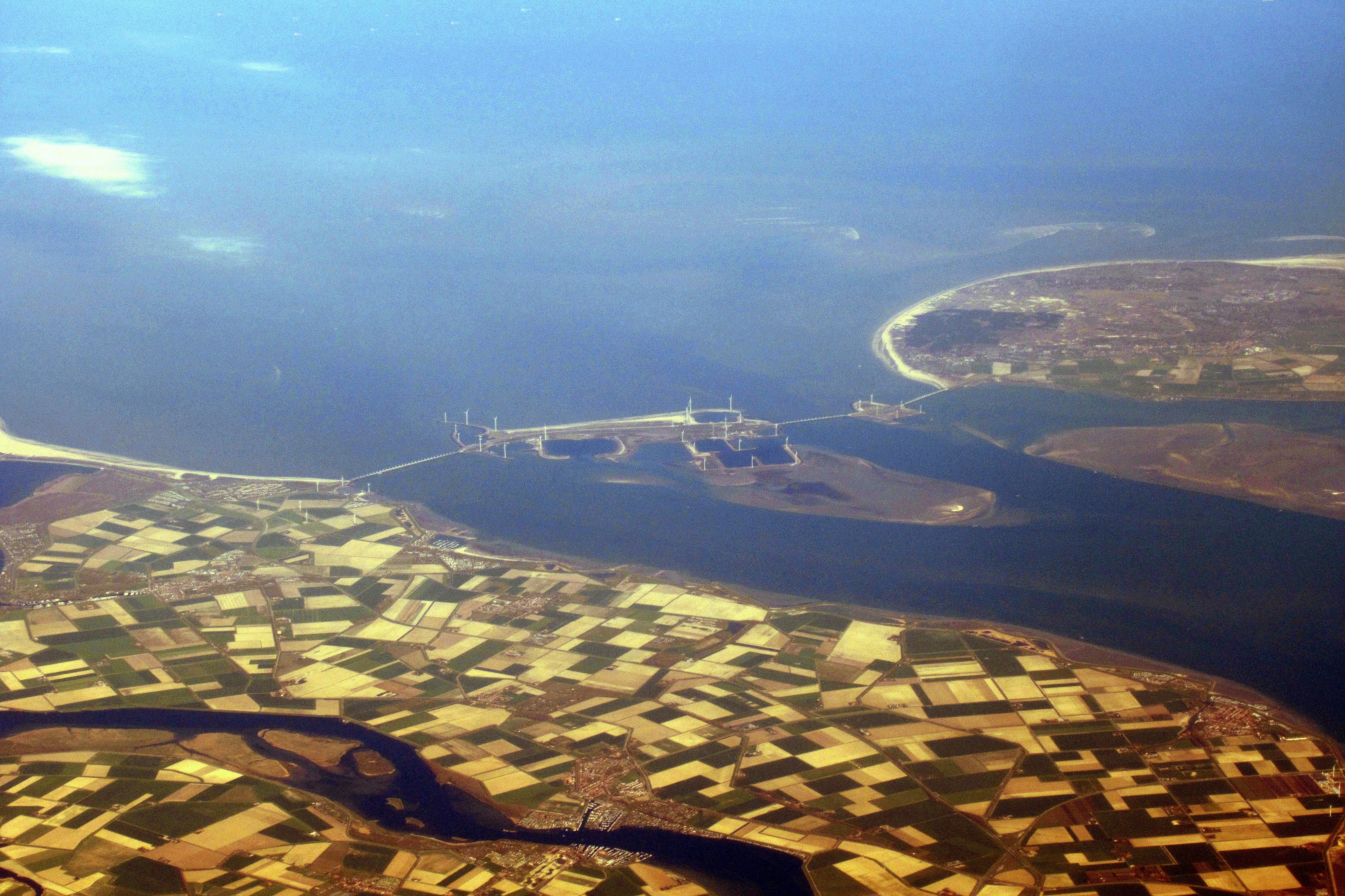
From the Air
The Oosterscheldekering runs roughly east-west between Schouwen-Duiveland (north shore) and Noord-Beveland (south shore) at about 51.63°N, 3.70°E, with the artificial island Neeltje Jans in the middle. The full barrier is nine kilometres long and unmistakable from cruise — a thin causeway with the bulge of Neeltje Jans at its centre and visible regular spacing of pillars. Ideal viewing altitude 3,000–8,000 ft. Nearest airports: Midden-Zeeland (EHMZ) ~10 nm south, Rotterdam The Hague (EHRD) ~40 nm north, Antwerp (EBAW) ~55 nm east-southeast. Winter storms can produce dramatic photos with surf breaking on the barrier's seaward side; in calmer conditions the open sluice gates make an elegant geometric pattern from the air.