Oosterweel Link
In October 1996, the governor of Antwerp Province stood at a podium and announced that a five-kilometer tunnel would soon close the gap in his city's incomplete ring road. He thought the project would open by 2005. Nearly thirty years later the work is finally underway, the budget has passed ten billion euros, the design has been revised at least four times, the company managing it has changed its name twice, and the citizens of Antwerp once voted no in a referendum and got the tunnel anyway, just on a different route. The Oosterweel Link is what infrastructure looks like when democracy, geology, and asphalt all argue at once.
The Gap in the Ring
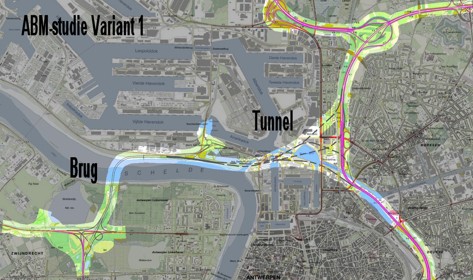
Antwerp's R1 motorway loops around the city - except on the north, where the great industrial bend of the Scheldt and the port have always interrupted it. Trucks and commuters squeeze through the Kennedy Tunnel south of the centre or through the Liefkenshoek Tunnel further west, and the rest jam the inner streets. By the 1990s the modelling was bleak: without a northern crossing, traffic would simply seize up by 2010. A new link, a third Scheldt crossing tying the E34 expressway on the left bank to the ring road at Merksem on the right, became the Flemish Government's biggest road priority. They created a holding company - Beheersmaatschappij Antwerpen Mobiel, BAM - and started designing.
Bridge or Tunnel
The first plans showed a bridge, because a bridge would have given Antwerp a landmark. The Scheldt's low vertical clearance killed that. The engineers settled instead on a viaduct soaring over the docks and the Albert Canal - the Lange Wapper, named in 2005 for a giant of Antwerp folklore. The estimate climbed: 550 million euros in 2000, 950 million in 2004, 1.345 billion in 2005, 2.5 billion in 2008. Citizens watched the renderings and did not like what they saw. A neighbourhood action group called stRaten-generaal proposed an alternative route further north, through a bored tunnel that would avoid the dense Merksem flats and the schools beneath the planned flyover. Another group called Ademloos - 'breathless' - took up the cause of air quality. The fight was on.
The Referendum
On 18 October 2009 the city of Antwerp held an advisory referendum. The question was whether to support the BAM viaduct route. The answer: 40.76 percent yes, 59.24 percent no. The vote was not binding, but it was clear, and four days later the Flemish government created a new ministerial commission to find a way forward. Independent consultants from Arup and SUM had already concluded that all the proposed routes were technically feasible, none of them profitable under the Flemish Government's chosen financing model, and the citizens' alternative scored highest on environmental and quality-of-life indicators. The political will collapsed around the viaduct. By September 2010 the government had agreed to tunnel the route instead. The Lange Wapper - the bridge that briefly promised to be a new symbol of Antwerp - quietly disappeared from the maps.
Lantis, and Concrete at Last
BAM kept changing tactics and eventually changed its name. In 2009, during the referendum campaign, it had marketed itself as 'Vooruit met Antwerpen' - Forward with Antwerp. In 2019 it rebranded again, this time permanently, as Lantis. The new approach treated the Oosterweel Link as one piece of a wider Antwerp Masterplan: not just the missing northern link, but also the A102, the R11 tunnel, capping of the existing ring road, ecoducts, walking and cycling bridges - sixteen integrated projects designed to reconcile commuters and residents at once. Total costs ballooned again, now into the ten-billion-euro range. Construction broke ground in 2018. The Scheldt crossing is being built as an immersed tube tunnel, with concrete elements floated into place and sunk in a dredged trench. Completion of the full Oosterweel Link is projected for the early 2030s - roughly forty years after Camille Paulus first stood at his podium and said 2005.
What the Saga Built
Whatever the final structure looks like, the citizens of Antwerp have already changed it. The flyover is gone. The R1 will be capped with parks for kilometres through the city, an Antwerp version of Madrid's M-30 project, joining neighborhoods that the motorway split in two for half a century. Air quality measures, noise barriers, dedicated freight routing through the new tunnel - all of these are concessions hammered out across two decades of marches, lawsuits, expert reports, parliamentary commissions, and a referendum. The Oosterweel saga has taught Flemish planners that infrastructure cannot be presented as a fait accompli, and it has taught Antwerp activists that the slow road sometimes ends where you wanted it to. The dredgers and tunnel-boring machines that now hum under the Scheldt are building roads. They are also building a different model of how a Belgian city argues with itself about its own future, and ultimately decides.
From the Air
The Oosterweel Link will close the R1 Ring Road on Antwerp's north side at roughly 51.25°N, 4.40°E. The route runs from the E34 expressway near Blokkersdijk on the Scheldt's left bank, under the river via an immersed tube tunnel, through new road tunnels under the Albert Canal, and joins the existing R1 at Merksem and Deurne. Visible from the air as construction zones along Antwerp's northern docks; Antwerp International Airport (EBAW) sits within the future ring. Brussels (EBBR) lies 40 km south. Best viewed from low altitude to see active construction sites in the harbour.