Operation Big Bang
One in the afternoon, Friday, 18 April 1947. From the bridge of HMS Lasso, seventeen kilometres off the German coast, a British engineer pressed a button. A second later, the southern half of the island of Heligoland erupted. Four thousand torpedo warheads, nearly nine thousand depth charges, and ninety-one thousand artillery shells - all of it surplus from a war that had ended two years before, all of it packed into the submarine bunker and tunnel system beneath the island. Thirteen terajoules of stored fury, about 3.2 kilotons of TNT equivalent, the largest planned non-nuclear explosion in human history to that point. The blast was meant to flatten Heligoland and erase a German naval base from the map. It failed. The island is still there.
Why the British Wanted It Gone
Heligoland's military problem was geography. Sitting in the centre of the German Bight, near the mouths of the Weser, the Elbe, and the Kiel Canal, the island had been a naval pivot point for as long as anyone could remember - four naval battles in 1849, 1864, 1914, and 1917, and an air battle in 1939. Britain had owned the place from 1807 until 1890, then traded it to Germany in the Heligoland-Zanzibar Treaty, then watched the Kaiser turn it into a fortress, then watched Hitler try to expand that fortress under the never-finished Project Hummerschere - "Project Lobster Claw." After 1945, with Heligoland in the British occupation zone and the inhabitants evacuated, the calculus was simple. Leave the bunkers and the submarine pens intact and a future German navy might one day use them again. Demolish them properly and the problem ended.
Stacking the Bomb
The British did not have to build the bomb. They had to gather it. The world wars had left immense surplus ammunition stockpiles across northwest Europe, and Heligoland's tunnel labyrinths and the Nordsee III submarine bunker in the southern harbour were already designed to hold munitions. Royal Navy parties began ferrying surplus warheads in through 1946 and into 1947, stacking the torpedo heads in the bunker, the depth charges in the side tunnels, the shells in any vault that would take them. The original detonation date was 31 March 1947, but the preparations ran long. The new date - 18 April - was chosen deliberately. It was exactly two years to the day after the Royal Air Force bombing raid that had finished the German garrison.
The Bird Warning and the Fireball
The British wanted witnesses. They produced a brochure for the German public, invited journalists aboard the steamer Danzig to watch from a safe distance, and even fired a smaller charge a few minutes before the main detonation - a warning shot, intended to scatter the seabirds that nested on the cliffs before the real explosion incinerated them. Then HMS Lasso's engineers triggered the main charge. A column of fire and rock rose into the sky. Reports of the mushroom cloud's height disagree wildly - some sources say one kilometre, others nine. The seismographs were unequivocal. The tremor was felt in Cuxhaven, seventy kilometres away, and the detonation was registered by seismographs across northern Germany. Geophysicists later used the recording to study the structure of the Earth's crust beneath the North Sea. The bomb wasn't only a demolition. It was a free piece of seismology.
Why the Island Survived
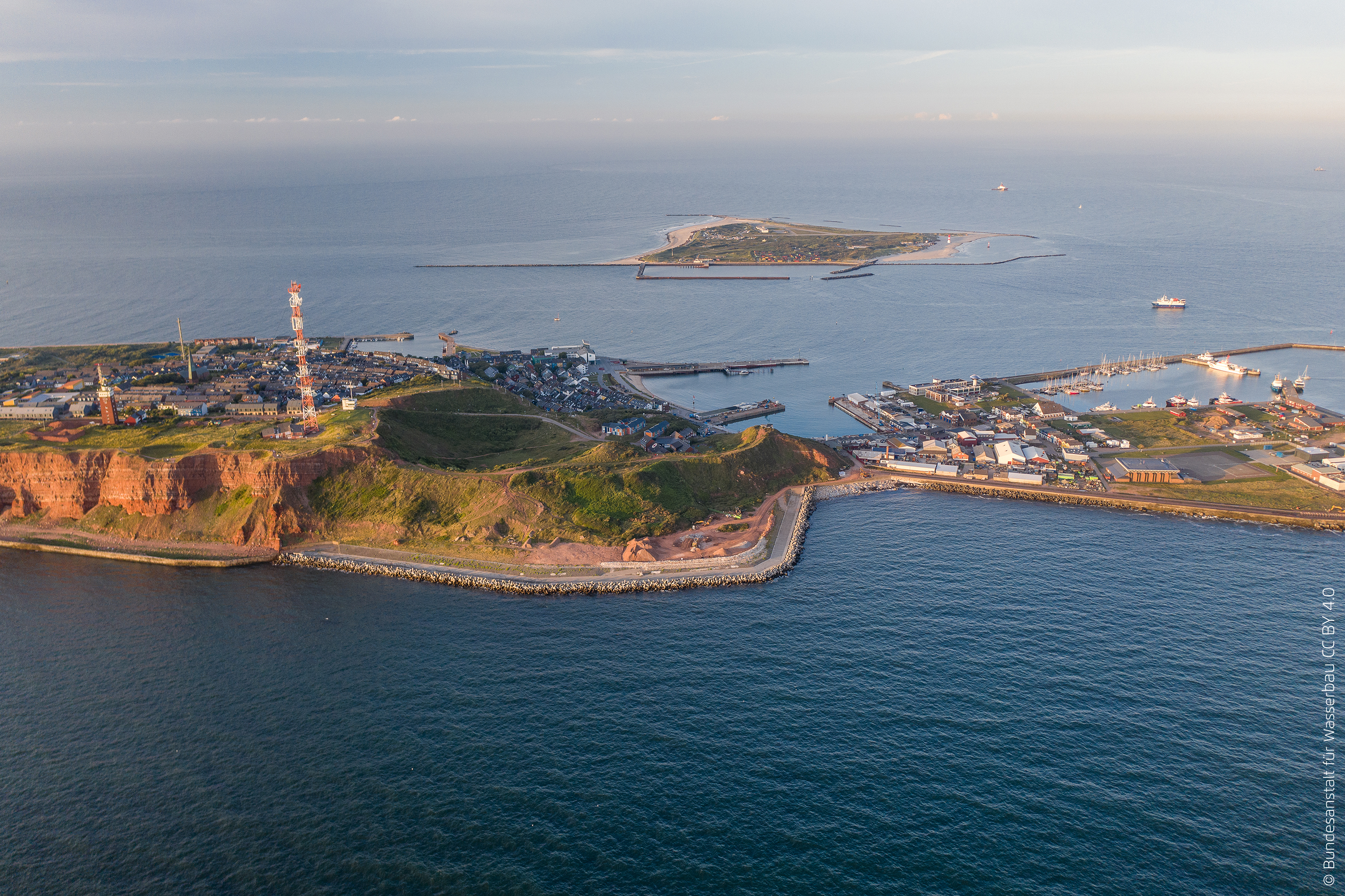
Heligoland is sandstone. Porous, red, layered sandstone, riddled with the bunker tunnels and natural cracks that turned out to be exactly what was needed to save the island. The blast wave found those gaps and escaped upward and outward instead of shattering the foundation. The southern tip blew apart - the rubble forming what islanders now call the Mittelland, the Middle Land that sits between the harbour and the cliffs. The northern cliffs cracked and shed slabs. Many craters opened across the island. But the bones of Heligoland held. Even more remarkably, the harbour walls and coastal defences survived intact. So did the bunker system the British had counted on filling: today the surviving civil air-raid shelters attract up to ten thousand tourists a year, and the only structure left standing at the very centre of the blast was the flak tower - which, in 1952, was converted into Heligoland Lighthouse and still throws the strongest beam on the German North Sea coast.
The Islanders Came Back
British forces continued to use Heligoland as a bombing and training range from 1945 to 1952. The displaced islanders, who had been evacuated in April 1945 to mainland Germany, watched their home being used as target practice and lobbied increasingly loudly for its return. Two German students famously occupied the island in December 1950 to plant flags and protest. By 1952, public pressure on both sides of the North Sea reached the British government, and Heligoland was returned to West Germany. The islanders went home. They rebuilt. Today, on every anniversary of the blast, a memorial service is held in one of the civil defence bunkers - among the very tunnels the British had filled with explosives to erase the place. The island remembers. It did not stop being itself.
From the Air
The detonation site sits at the southern end of Heligoland's main island, around 54.1825°N, 7.8853°E. From the air today, the legacy is visible: the Mittelland - a low plateau of blast rubble between the harbour and the Oberland cliffs - was created by this explosion. The flak tower that became Heligoland Lighthouse stands at the centre. Heligoland-Düne airfield (EDXH) is on the smaller Düne island just east. Cuxhaven (EDHC) is the nearest mainland alternate. Approach with caution: the airspace around Heligoland is busy with offshore wind farm helicopter traffic, weather changes fast, and the field has no instrument approach.