Ordesa Valley
They called it the Lost Mountain because you cannot see it from France. Monte Perdido, at 3,355 metres the third highest peak in the Pyrenees, hides behind a wall of ridges that renders it invisible from the north. The name stuck - Perdido means lost in Spanish - and the mountain presides over one of the most dramatic landscapes in southern Europe: the Ordesa Valley, an eleven-kilometre glacial trough carved through limestone in the heart of Aragon. The valley was not mapped in detail until the 1920s, a full century after its first documented exploration in 1820. Even now, it retains the quality of a place that keeps its secrets reluctantly.
A Valley Turned Sideways
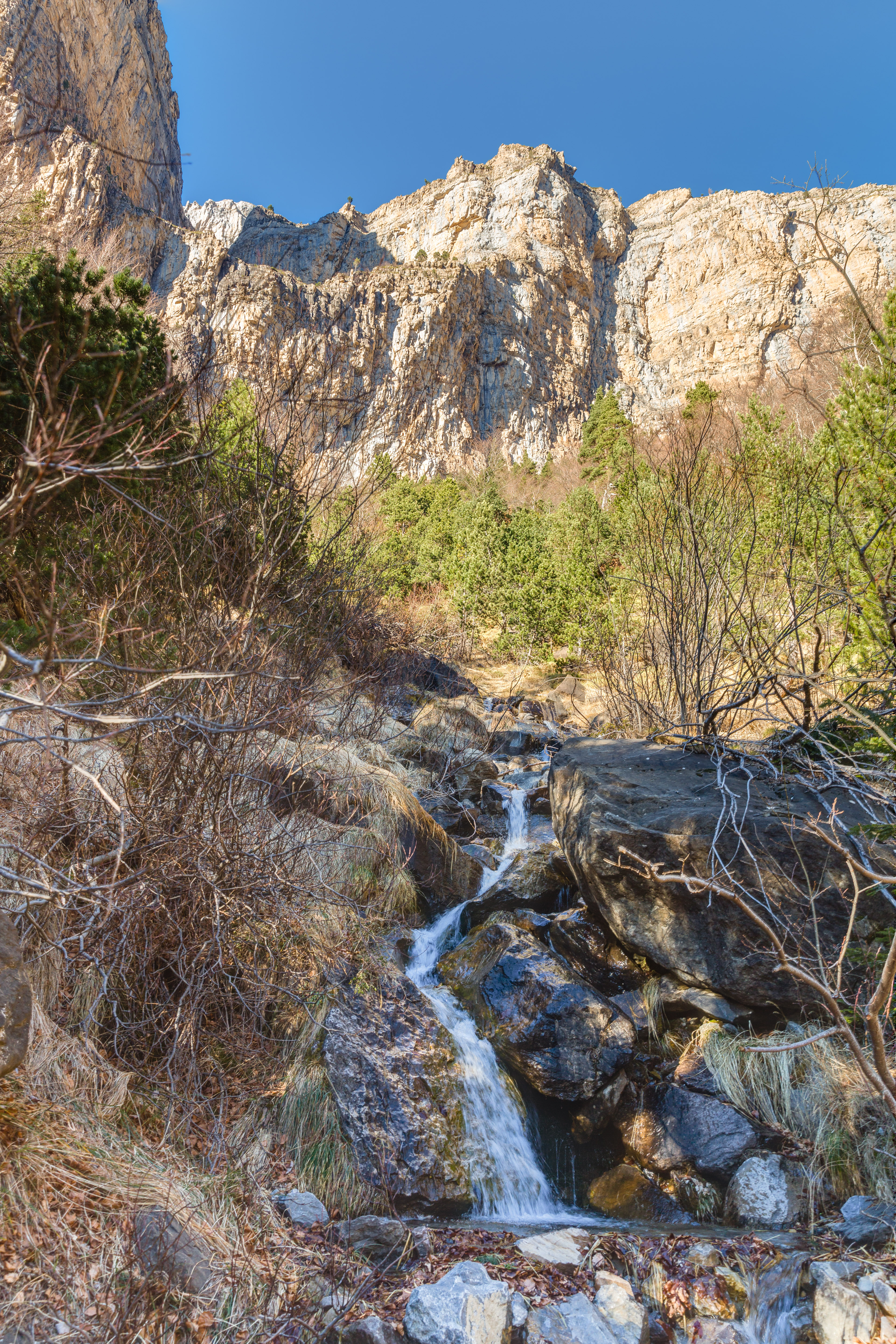
Most Pyrenean valleys run north-south, draining from the ridgeline toward the lowlands on either side. Ordesa runs east-west, and that unusual orientation changes everything about its character. The valley's open western end faces the Atlantic Ocean, funneling moist maritime air deep into the mountains. The result is a climate far more moderate than the surrounding peaks would suggest - lush beech and fir forests carpet the lower slopes, fed by rainfall that neighboring valleys oriented differently do not receive. Waterfalls cascade from the limestone cliffs that form the valley walls, some of them dropping hundreds of metres in seasonal torrents fed by snowmelt and Atlantic storms. The valley is part of the Ordesa y Monte Perdido National Park, which protects this entire ecosystem.
The Three Giants
At the valley's northeastern head, three peaks define the skyline. Monte Perdido dominates at 3,355 metres, flanked by Cilindro de Marbore at 3,328 metres and Soum de Ramond at 3,263 metres. Together they form a wall of limestone that closes off the valley in a dramatic amphitheatre of vertical rock and hanging glaciers. The geology here tells a story of deep time: these are sedimentary mountains, built from seabed deposits laid down when the Pyrenees did not exist and an ocean covered this ground. The forces that lifted the limestone to more than three thousand metres also fractured it, creating the joint systems that water exploits to carve the waterfalls and gorges that make the valley so striking from below.
Where the Chamois Run
The valley shelters one of Europe's largest populations of the Pyrenean chamois, the agile mountain goat-antelope that navigates cliff faces with an ease that borders on the absurd. These are not the chamois of the Alps - the Pyrenean subspecies is smaller and darker, adapted to the particular conditions of these southwestern mountains. The chamois share the valley with golden eagles, lammergeiers that crack bones by dropping them from height onto rocks below, and a rich community of alpine and subalpine species that benefit from the valley's protected status. The mix of Atlantic-influenced forest at lower elevations and alpine meadows higher up creates habitat diversity unusual for a single valley, supporting species from woodland warblers to high-altitude specialists within a few kilometres of each other.
A Century of Discovery
The timeline of Ordesa's exploration reflects how remote these mountains remained well into the modern era. The first documented visit occurred in 1820, but detailed mapping did not follow for another hundred years. Through the 19th century, the valley was known mainly to shepherds and the occasional mountaineer willing to navigate approaches that lacked proper trails. The establishment of the national park brought infrastructure and accessibility, but the valley retains a wildness that more accessible mountain destinations have long since lost. The approach from the south winds through the villages of the Aragonese Pyrenees, climbing through terraced hillsides and dense forest before the valley opens up in a sudden reveal of limestone walls and cascading water. For those arriving on foot, as the first explorers did, the view at the valley mouth remains one of the great arrivals in European mountain travel.
From the Air
The Ordesa Valley lies at approximately 42.65N, 0.06W in the central Spanish Pyrenees, running east-west for about 11 kilometres. Monte Perdido (3,355 meters) and its companion peaks form the dramatic headwall at the northeast end. Best viewed at 5,000-8,000 feet AGL from the south for a clear view into the valley and its waterfalls. The nearest airport is Huesca-Pirineos (LEHC), approximately 50 nautical miles south. Pau Pyrenees Airport (LFBP) is about 40 nautical miles north across the border. Mountain flying caution is essential: strong thermals, rotor turbulence, and rapidly changing weather are common. Cloud can fill the valley quickly.