Ordesa y Monte Perdido National Park
The last Pyrenean ibex died on January 6, 2000, found beneath a fallen tree in the Ordesa Valley. Her name was Celia, and she was the final member of a subspecies that had roamed these mountains for thousands of years. The park that was supposed to save her -- Ordesa y Monte Perdido, established in 1918 and expanded to 156 square kilometers in 1982 -- had not been enough. That failure hangs over a landscape so dramatic it earned UNESCO World Heritage status, a place where the beauty is real and the losses are permanent.
Written in Limestone
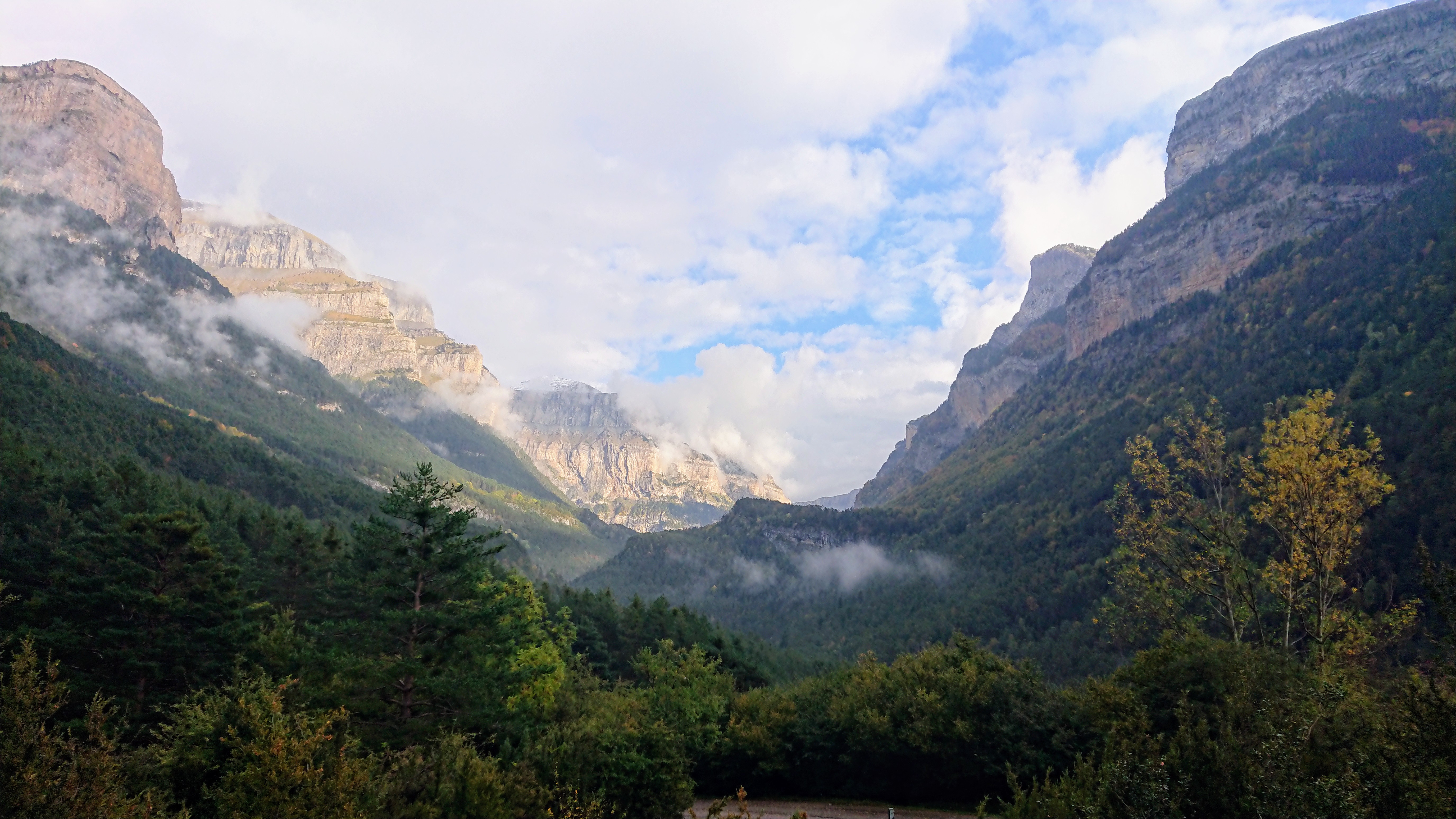
The geology here reads like a textbook of deep time made visible. The park sits on limestone laid down during the Cretaceous and Eocene periods, then thrust skyward by the tectonic forces that built the Pyrenees. Water and ice have been sculpting ever since. Quaternary glaciers carved the massive U-shaped valleys and cirques that define the landscape -- the Cirque de Soaso, the Cirque de Cotatuero, the deep slot of Anisclo Canyon. Monte Perdido itself, at 3,355 meters, is the third-highest peak in the Pyrenees, and its limestone mass is riddled with karst formations: sinkholes, caverns, and channels where water disappears and reappears according to its own subterranean logic. The altitude range -- from 750 meters at the mouth of Anisclo to the summit of Monte Perdido -- creates temperature swings and thermal inversions that stack entirely different ecosystems on top of each other.
A Forest in Layers
Walk uphill from the valley floor and you pass through a vertical catalogue of European forests. Below 1,700 meters, beeches, silver firs, Scots pines, and sub-Pyrenean oaks form dense canopies, while birches, ashes, and willows fill the gaps. Boxwood thickets claim the slopes from 700 to 1,800 meters. Higher, the mountain pine takes over, its twisted forms marking the transition to subalpine territory. Above 1,700 meters, the meadows begin -- and with them, the endemics. Plants like Borderea pyrenaica and Ramonda myconi have survived here since before the last ice age, relics of ancient floras clinging to specific altitude bands. The edelweiss, that symbol of alpine inaccessibility, grows in the highest meadows and has become one of the park's emblems.
What Flies, What Remains
The skies above Ordesa belong to raptors. Golden eagles patrol the ridgelines. Bearded vultures -- lammergeiers -- ride thermals along the canyon walls, their wingspan reaching nearly three meters as they search for bones to drop from height and crack open for marrow. Griffon vultures circle in loose groups above the cliffs, while Eurasian eagle-owls hunt the twilight hours. On the ground, Pyrenean chamois navigate slopes that would defeat any human climber, and alpine marmots whistle warnings from their boulder fields. The Pyrenean desman, a strange aquatic mole found nowhere else, hunts invertebrates in the park's cold streams. These survivors share the landscape with the absence of the bucardo, whose extinction in 2000 marked the first time a species vanished from a Spanish national park.
Champions of the Cause
Ordesa owes its protection to a handful of advocates who recognized what was at stake before it was fashionable to do so. French photographer and explorer Luciano Briet documented the valleys and canyons with images that brought them to public attention. Catalan mountaineer Soler i Santalo and geologist Lucas Mallada y Pueyo championed the region's scientific value. Their efforts culminated on August 16, 1918, when a Royal Decree declared 21 square kilometers of the Ordesa Valley a national park -- making it one of Spain's first. The 1982 expansion brought in Monte Perdido and the surrounding canyons, and in 1997 UNESCO designated the cross-border Pyrenees-Mont Perdu site as a World Heritage Site, recognizing the spectacular geology that straddles the French-Spanish border. The landscape those early champions fought to preserve now draws hikers to the Cola del Caballo waterfall, climbers to the Breche de Roland, and anyone willing to stand at the edge of the Cirque de Soaso and feel the scale of what moving ice can accomplish.
From the Air
Located at 42.67N, 0.06E in the central Spanish Pyrenees, Aragon. Monte Perdido (3,355 m) is the dominant peak, visible from high altitude as a massive limestone massif. The deep canyons of Ordesa, Anisclo, Escuain, and Pineta radiate from the central peak. Nearest airports are Huesca-Pirineos (LEHC) approximately 100 km south and Pau Pyrenees (LFBP) approximately 80 km north on the French side. Approach from the south for dramatic views of the canyon systems cutting into the high plateau.