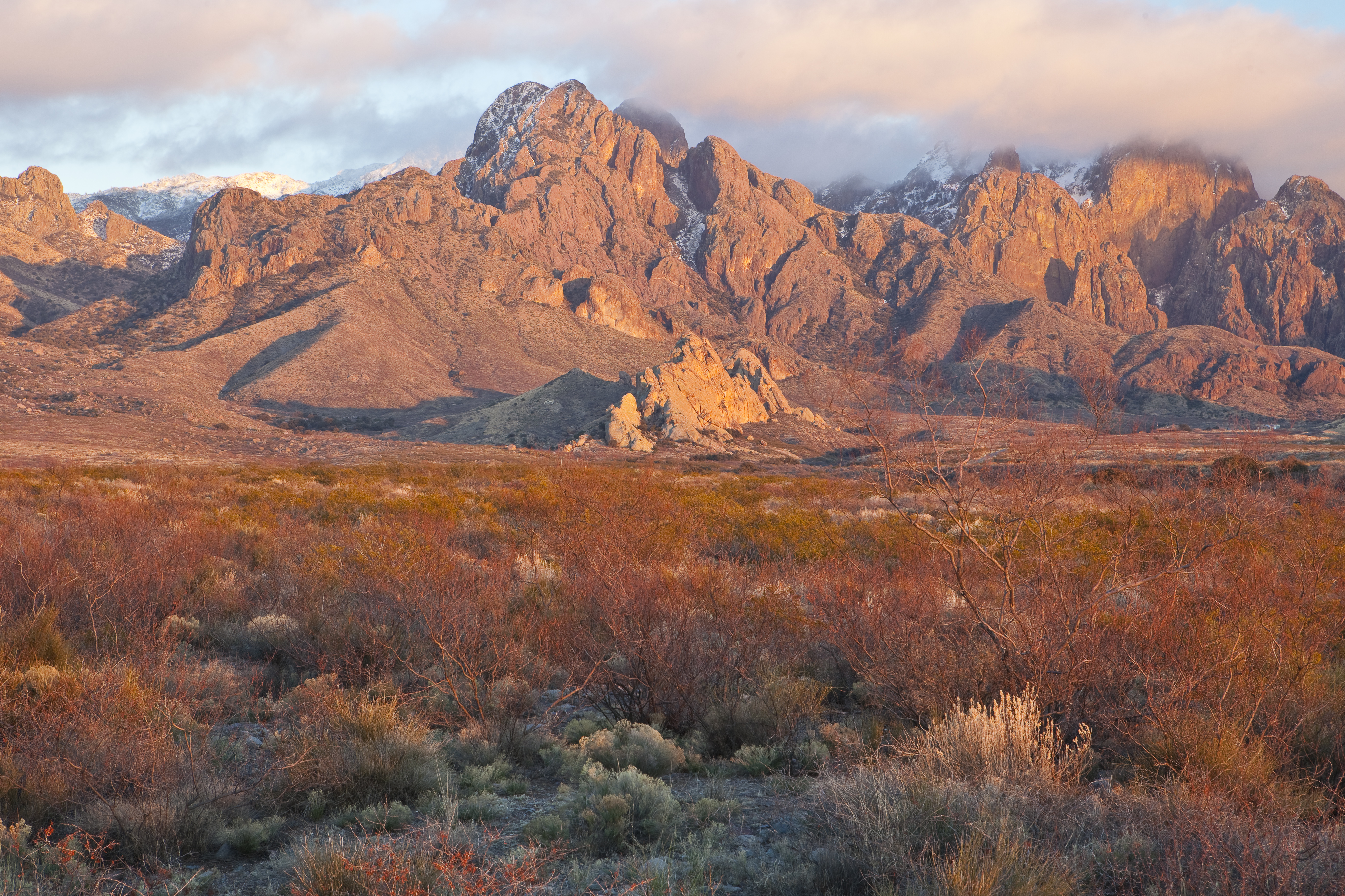
Organ Mountains
The Organ Mountains earned their name the honest way. Look at the granite spires from the Mesilla Valley floor, especially at sunrise or sunset, and you see it immediately: a row of vertical pipes, natural organ columns thrusting skyward from the desert. The Mescalero-Chiricahua Apache called them Tsé daadeezhá-yá. Spanish colonists named them La Sierra de los Órganos. On May 21, 2014, President Obama designated them the centerpiece of the Organ Mountains-Desert Peaks National Monument, permanently protecting over 496,000 acres of southern New Mexico's most dramatic landscape. The highest point, Organ Needle, reaches 8,982 feet, nearly a mile above the city of Las Cruces just twelve miles to the west.
Three Mountains in One
The Organ Mountains are actually three distinct geological sections compressed into a single range. On the north end rises The Needles, a narrow ridge of Tertiary granite, more precisely a quartz monzonite, with vertical joints that create the iconic organ-pipe silhouette. This section includes Organ Needle itself, the summit. South of The Needles spreads a much wider mass of purplish-gray rhyolite, extrusive volcanic rock that forms the bulk of the range and reaches heights nearly as impressive. Soledad Canyon cuts through this central section from east to west. The third portion, consisting of Bishop's Cap Hills and Rattlesnake Ridge, sits lower on the southwest and southeast flanks, composed of fault-block limestone similar to the neighboring San Andres and Franklin Mountains. The rock beneath these peaks is ancient, roughly 1.75 billion years old, forged when volcanic eruptions in Precambrian seas mixed magma with cold seawater to deposit copper, gold, silver, and zinc in the cracks.
A Botanical Island in the Desert
Few mountain ranges in the Southwest pack as much botanical diversity into such a compact area. The Organ Mountains harbor approximately 870 vascular plant species, including several found nowhere else on Earth. The Organ Mountains evening-primrose and the smooth figwort exist only in small, scattered populations on these slopes. Thirty of New Mexico's 56 fern species grow here. The flora differs dramatically between the igneous and limestone sections of the range. The southern limestone hills host some of the northernmost populations of lechuguilla, a spiny agave considered an indicator species of the Chihuahuan Desert. The granite and rhyolite sections have botanical affinity with the Madrean flora of the sky islands farther south, making the Organs a biological crossroads where desert and mountain ecosystems collide.
Climbers and Trails
The first documented climbs of Organ Mountain peaks came in the early 1890s, but the range's modern climbing history belongs largely to the 1950s, when soldiers stationed at Fort Bliss and faculty from New Mexico State University pioneered routes on the granite spires. R.L. Ingraham's Guide to Climbing in the Organ Mountains remains the definitive reference. Today, the Bureau of Land Management maintains hiking trails accessed from four sites. Aguirre Springs Campground and Baylor Canyon Road offer access to The Needles from east and west, including the 4.5-mile Pine Tree Trail loop that climbs through mountain mahogany scrub to ponderosa pine woodland. Dripping Springs Natural Area provides trails into Fillmore and Ice Canyons. The Soledad Canyon Day Use Area has a loop trail in Bar Canyon. The southern limestone section, however, remains difficult to reach, with no developed trails and Rattlesnake Ridge entirely closed to the public within Fort Bliss boundaries.
Monument and Threat
When President Obama signed the proclamation creating the national monument in 2014, White House press secretary Jay Carney emphasized the protection of prehistoric, historic, and scientific values. The Organs contain evidence of human occupation stretching back thousands of years, and the range's unique ecology demanded permanent safeguarding. But designation alone cannot hold back all threats. The protected lands face pressure from the expansion of Las Cruces, energy development, mining interests, invasive species, and increasing aridity driven by climate change. The monument status provides legal framework, but the long-term survival of endemic species like the evening-primrose depends on vigilance and adaptation in a warming world.
The Spires From Above
From the air, the Organ Mountains present an unmistakable profile: a dark, jagged wall rising abruptly from the desert floor east of Las Cruces. The granite needles of the northern section stand out sharply, their vertical faces catching light differently than the surrounding rhyolite slopes. San Augustin Pass, where U.S. Highway 70 crosses to White Sands Missile Range and Alamogordo, is clearly visible as a low saddle separating the Organs from the San Andres Mountains to the north. To the south, Anthony Gap creates a ten-mile-wide lowland between the Organs and the Franklin Mountains extending into El Paso. The green thread of the Rio Grande and the grid of Las Cruces spread west of the range, while the white expanse of White Sands glimmers on the northeastern horizon. The contrast between the organ-pipe spires and the flat desert basin is dramatic at any altitude.
From the Air
The Organ Mountains are located at approximately 32.33N, 106.59W, rising to 8,982 feet MSL at Organ Needle. The range presents significant terrain east of Las Cruces. San Augustin Pass (U.S. 70) separates the Organs from the San Andres Mountains at approximately 5,700 feet. White Sands Missile Range restricted airspace lies to the northeast. Las Cruces International Airport (KLRU) is approximately 15 nm west. Best viewed from the west or southwest at 10,000-12,000 feet to appreciate the full profile against the Tularosa Basin. Watch for mountain turbulence along the ridgeline and afternoon thunderstorms during monsoon season.