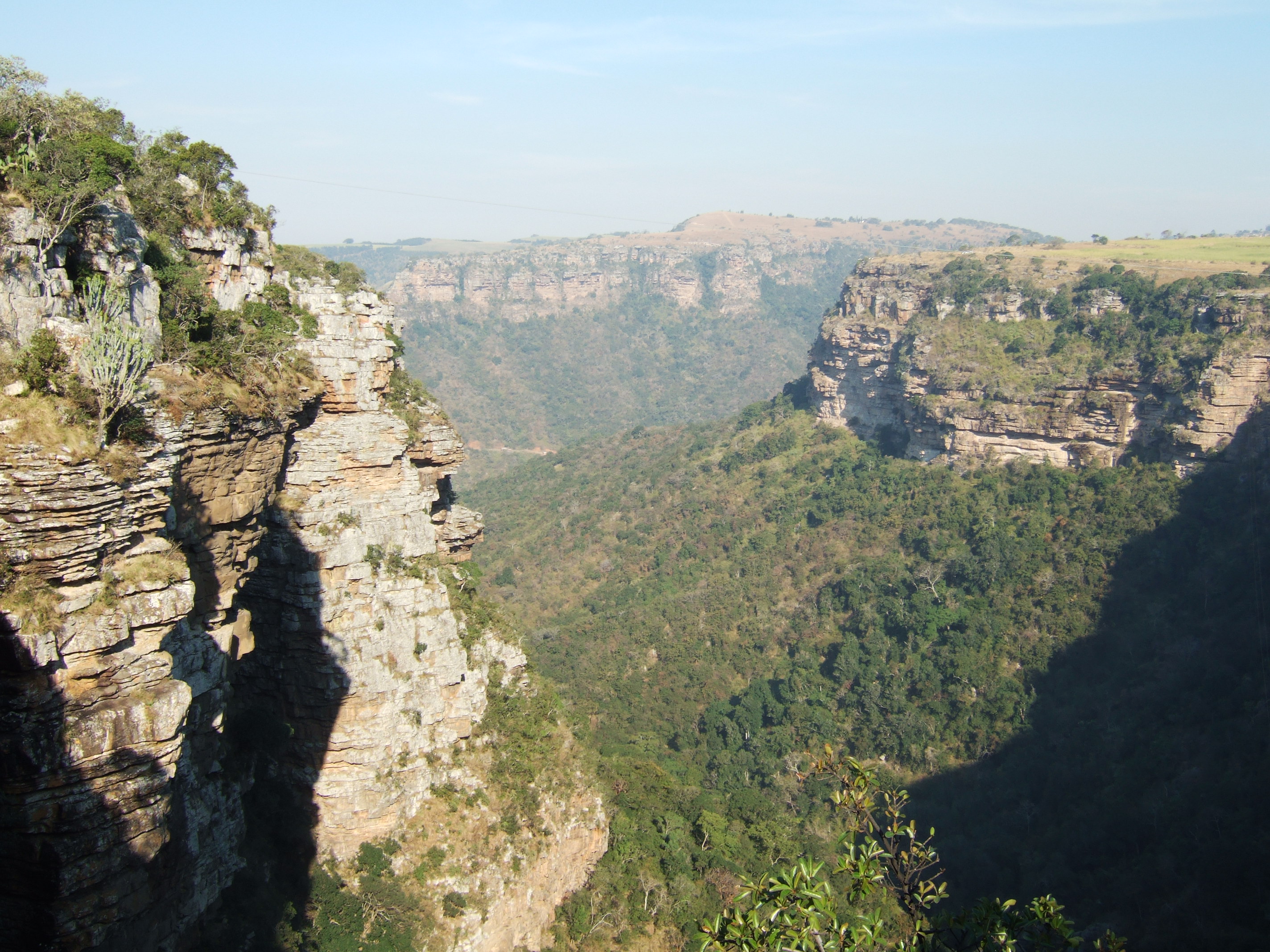
Oribi Gorge
The oribi is a small, slender antelope that stands barely 60 centimeters at the shoulder and freezes when threatened, trusting its tawny coat to blend into the grassland. It is the kind of animal you could walk past a dozen times and never notice. The gorge that bears its name is the opposite: 400 meters deep, nearly five kilometers wide at its broadest, and impossible to ignore. Oribi Gorge slashes through the flat sugarcane farmlands of southern KwaZulu-Natal like a wound, revealing rock so ancient that the cliffs themselves are older than most life on Earth. Two rivers did this work, the Mzimkulwana and the Mzimkulu, carving nearly 30 kilometers of subtropical canyon through sandstone laid down 365 million years ago atop a metamorphic basement that dates back more than a billion years.
A Billion Years of Basement Rock
At the base of Oribi Gorge's cliffs, the exposed rock belongs to the Namaqua-Natal Metamorphic Province, a formation over 1,000 million years old. These are not sedimentary layers deposited in calm seas but metamorphic rocks transformed by immense heat and pressure deep within the Earth's crust. Above them, the Msikaba Formation sandstones form the vertical walls that give the gorge its dramatic profile. These sandstones were deposited roughly 365 million years ago by ancient rivers, long before the age of dinosaurs, in a world where the continents were still assembling into the supercontinent Pangaea. The geological layering is visible in the cliff faces: pale sandstone cliffs sitting atop darker, more tortured metamorphic rock, two chapters of Earth's history stacked one upon the other. Downstream from the gorges, a limestone deposit supports a large surface mine producing cement, a reminder that the same geological forces that created the canyon's beauty also deposited commercially valuable minerals.
Kloofs, Crags, and Creatures
The subtropical forest that cloaks the gorge's sandstone slopes is dense and layered, a canopy of green draped over nearly 30 kilometers of kloofs and crags. In this tangled vegetation, bushbuck pick their way through the undergrowth and duiker freeze at the sound of footsteps. Vervet monkeys move in noisy troops through the mid-canopy, while the rarer Samango monkeys keep to the higher forest. Along the riverbanks, Nile monitors, the large leguaans that South Africans know well, excavate burrows in the soft earth. These prehistoric-looking reptiles can reach two meters in length and are surprisingly quick when startled. The gorge's rivers support frogs and freshwater turtles, and the reedbuck that graze the plateau edges above occasionally descend to the water. Oribi Gorge Nature Reserve, proclaimed a protected state forest in 1950, stretches 27 kilometers along the canyon floor at the confluence of the two rivers, preserving a corridor of habitat barely a kilometer wide but ecologically rich.
The Road the Prisoners Built
During World War II, Italian prisoners of war held in South Africa were put to work on infrastructure projects across the country. One of their assignments was the road through Oribi Gorge. The engineering challenge was formidable: the route had to navigate sheer cliff faces, cross unstable terrain, and survive the subtropical downpours that send torrents of water cascading through the canyon. The prisoners carved the road out of the sandstone walls, leaving behind a route that hugs the gorge's contours with the kind of precision that speaks to both skill and enforced patience. Today, driving this road is one of the best ways to experience the gorge, the cliffs rising on one side while the forest canopy drops away to the river below. The prisoners' work endures, a piece of wartime history embedded in the landscape of peacetime KwaZulu-Natal, largely unremembered by the tourists who drive it.
Where the Sugarcane Ends
The contrast between the gorge and its surroundings is striking. The Oribi Flats above are some of the most productive agricultural land in KwaZulu-Natal, quilted with sugarcane fields that stretch flat and green to the horizon. Then the ground simply falls away. Standing at the rim, you look down into a world that has nothing in common with the farmland behind you: a subtropical canyon of vertical cliffs, hanging forest, and the distant sound of water. Port Shepstone lies 35 kilometers to the southeast on the Indian Ocean coast, and Durban is 120 kilometers to the north, but neither feels remotely close from the canyon floor. The gorge creates its own microclimate, its own soundscape, its own sense of time. And somewhere in the grasslands along its rim, the small antelope that gave this place its name stands motionless, watching, trusting that you will walk right past.
From the Air
Coordinates: 30.72°S, 30.27°E, in southern KwaZulu-Natal, South Africa. The gorge is approximately 400 m deep and 5 km wide, carved through the flat Oribi Flats sugarcane farmlands. From the air, the canyon appears as a dark, forested cleft in otherwise flat agricultural terrain. Two rivers are visible: the Mzimkulwana (eastern gorge) and the Mzimkulu (western gorge). Port Shepstone lies 35 km to the southeast on the coast. Nearest airports: Margate (FAMG) approximately 20 nm south; Port Shepstone has no major airport; Durban King Shaka International (FALE) approximately 65 nm north-northeast. Weather is subtropical with afternoon thunderstorms common in summer. Low-level turbulence possible over the gorge due to thermal effects.