Oroville Dam Crisis
The emergency spillway had never been used since Oroville Dam's construction in 1968. On February 11, 2017, water flowed over it for the first time, and engineers watched in horror as the barren hillside began eroding at a rate no one had predicted. The concrete weir at the top of the spillway threatened to undermine and collapse, which would have sent a 30-foot wall of water crashing into the Feather River and flooding communities downstream. Within two days, 180,000 people fled their homes in the largest evacuation in California history.
Five Years of Drought, Then the Deluge
California had suffered through five consecutive years of drought when the storms arrived in early 2017. The parched ground could not absorb the excess precipitation. Lake Oroville, the second largest reservoir in the state, began rising rapidly. Oroville Dam, an earthen embankment dam on the Feather River east of the city of Oroville, serves multiple critical functions: flood control, water storage, hydroelectric power generation through the adjacent Edward Hyatt Powerplant's 819 megawatts of capacity, and water quality improvement for the Sacramento-San Joaquin River Delta. It is a cornerstone of the California State Water Project. As lake levels climbed toward capacity, operators began releasing water through the main spillway.
The Spillway Disintegrates
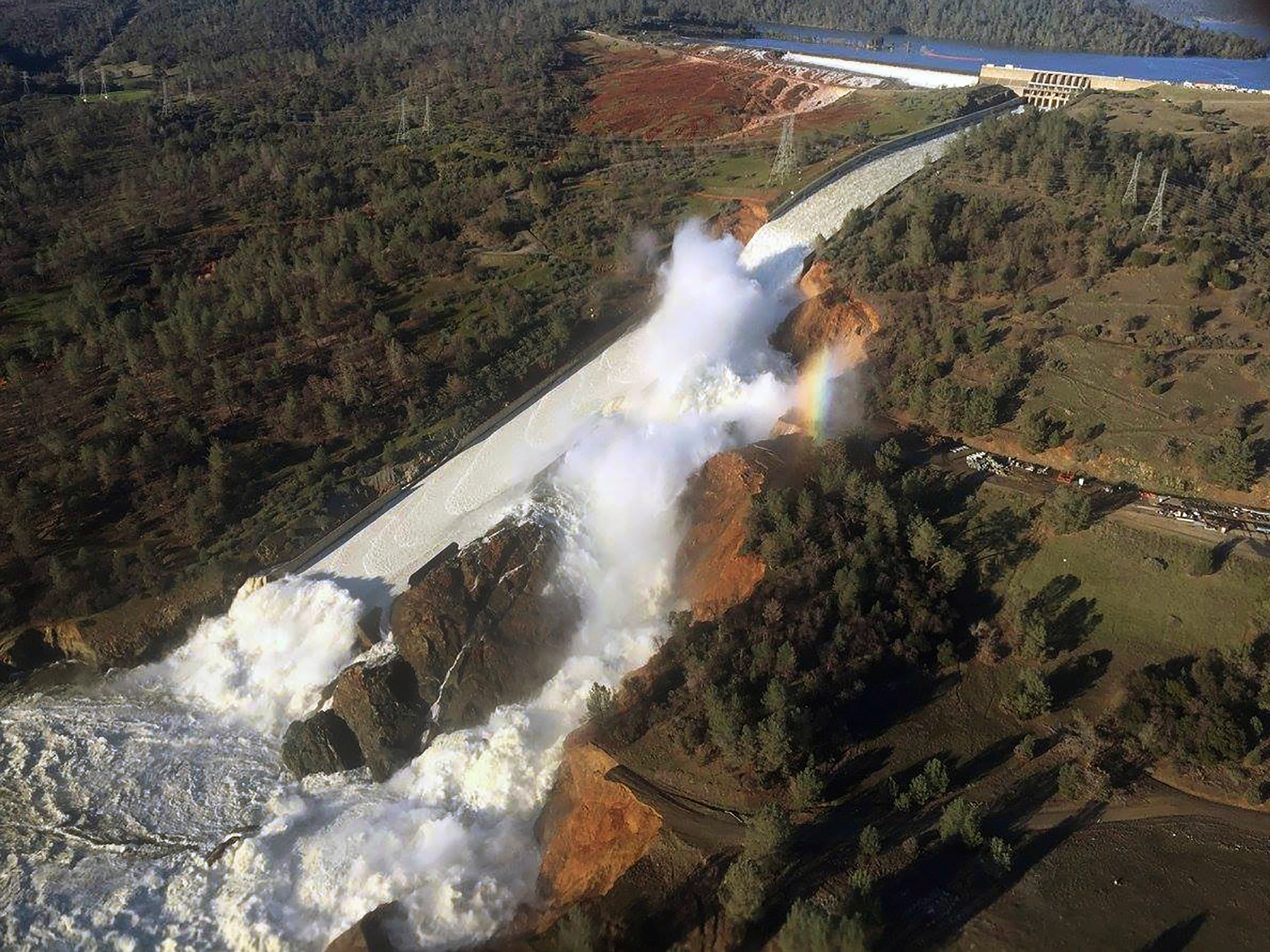
Damage to the main spillway first appeared on February 7, 2017. A crater opened in the concrete-lined channel, and as water continued to flow, the hole expanded. By February 10, the gaping wound in the spillway had grown large enough that operators faced an impossible choice: continue using the compromised main spillway and risk total failure, or reduce flow and let the lake rise toward the untested emergency spillway. They chose to reduce flow. On February 11, for the first time in the dam's history, water began flowing over the emergency spillway, a concrete weir at the top of a barren hillside that was never designed for sustained use.
Headward Erosion
The hillside below the emergency spillway began eroding far faster than engineers anticipated. Water carved into the slope, working its way uphill toward the concrete weir in a process called headward erosion. If the erosion undermined the weir, the entire structure could collapse, releasing an uncontrolled torrent into the Feather River. On February 12, with erosion accelerating and no good options remaining, authorities made the decision to evacuate. By February 13, over 180,000 residents of Butte County, Yuba County, and Sutter County had fled their homes. Emergency crews frantically reinforced the emergency spillway with rocks dropped by helicopter while simultaneously increasing flow through the damaged main spillway.
The Aftermath Below
The crisis created cascading problems downstream. Approximately 1.7 million cubic yards of erosion debris clogged the Feather River channel below the dam, blocking releases from the hydroelectric plant and reducing the dam's overall discharge capacity. State workers evacuated over nine million fish and eggs from the hatchery to a satellite facility near Thermalito Afterbay. On February 27, operators shut off flow to the main spillway, allowing crews to begin clearing debris from the river. By then, headward erosion had largely stabilized. The bedrock under the upper spillway proved stronger than the rock washed out from the midsection, and the falling water had excavated a deep plunge pool that dissipated energy and reduced further damage.
Lessons Carved in Concrete
Investigations by the Federal Energy Regulatory Commission and an Independent Forensic Team produced a nearly 600-page report in January 2018. Public hearings in May 2017 saw the California Department of Water Resources criticized for ignoring warning signs in the spillway's design. Environmental groups had raised concerns about the emergency spillway as early as 2005. Butte County officials complained that they spent $5.3 million annually on dam-related services with no state compensation. Repairs took over 2 million hours of labor. The main spillway was reconstructed by November 1, 2018. On April 2, 2019, water flowed over the new spillway for the first time, and it held. Periodic maintenance continues through 2025.
From the Air
Oroville Dam is located at 39.5426N, 121.492W, approximately 70 miles north of Sacramento. The dam and Lake Oroville are prominently visible from altitude, with the massive earthen embankment rising 770 feet above the riverbed. The main spillway descends the northwest face of the dam, and the scars from the 2017 crisis repairs remain visible. The Edward Hyatt Powerplant sits adjacent to the dam. Nearby airports include Oroville Municipal Airport (KOVE) approximately 4nm west and Chico Municipal Airport (KCIC) 20nm north. Best viewed at 3,000-5,000 feet AGL approaching from the west.