Oswald West State Park
Surfers call it Short Sands. They hike half a mile through a cathedral of old-growth Sitka spruce and western red cedar, boards tucked under their arms, to reach a cove that most coastal travelers never see. Smugglers Cove hides between Cape Falcon and Neahkahnie Mountain on Oregon's north coast, a crescent of dark sand where the Pacific funnels swells into clean, rideable waves. No road reaches it. No parking lot overlooks it. The only way in is on foot, through a forest so dense and green it feels like another century entirely. Oswald West State Park exists because of a single, radical idea: that a coastline should belong to everyone.
The Governor Who Saved the Shore
Oswald West served as Oregon's fourteenth governor from 1911 to 1915, and his most lasting legacy had nothing to do with budgets or highways. West championed the idea that Oregon's entire coastline - every beach, every tidal flat - should be public land, free from private fencing and development. He pushed the state legislature to declare the wet-sand zone a public highway, a legal maneuver that effectively blocked private owners from walling off the shore. The principle stuck. Oregon remains one of the few states where every inch of ocean beach is publicly accessible, a tradition that traces back to West's stubborn insistence that the sand was not for sale. The park that carries his name sits about ten miles south of Cannon Beach, straddling 2,448 acres of coast and forest between Arch Cape and the flanks of Neahkahnie Mountain.
Where the Rainforest Meets the Tide
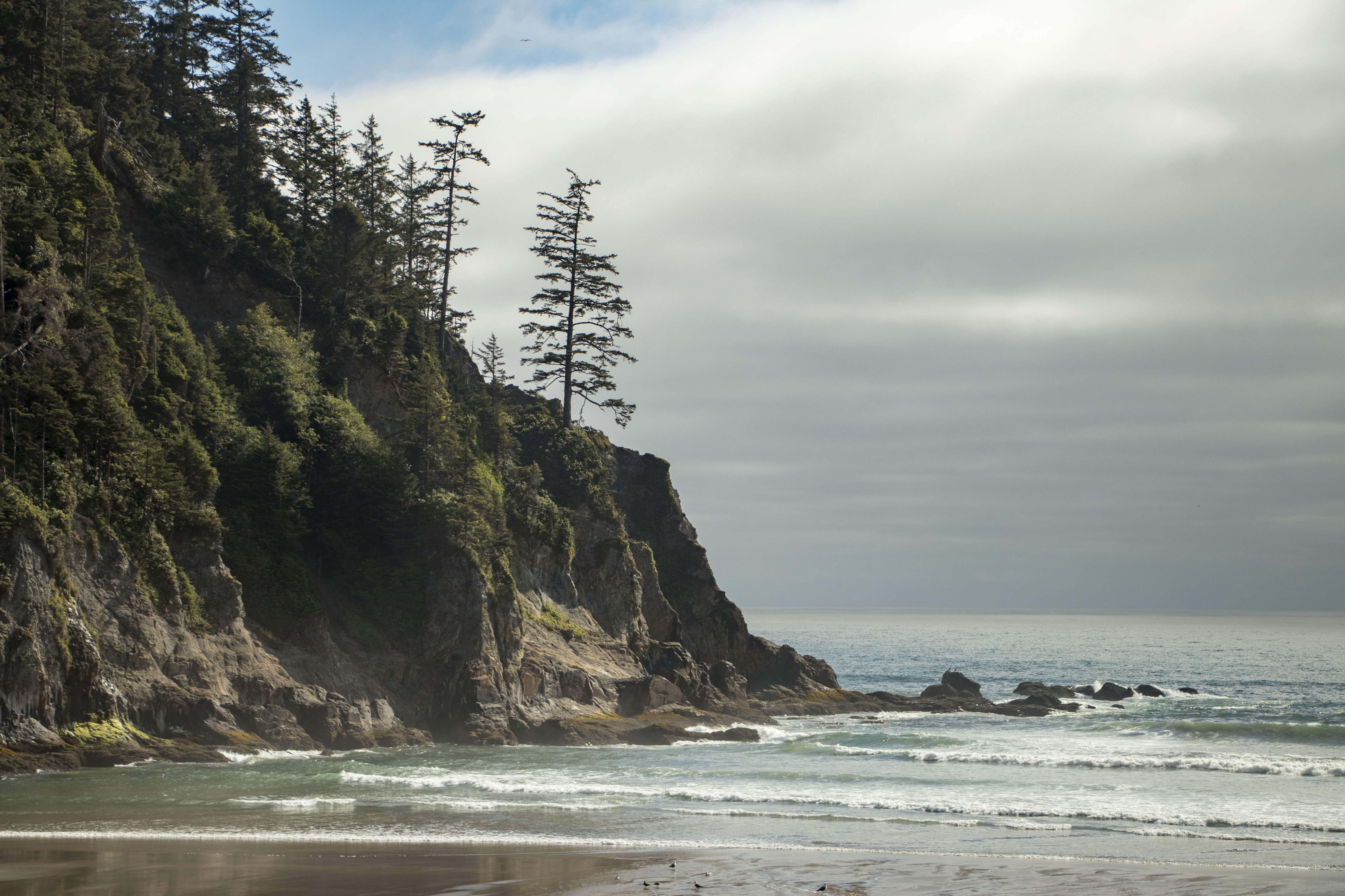
Walk the trail from the Highway 101 trailhead toward Short Sand Beach and the transition is immediate. The canopy closes overhead - towering Douglas-fir, western hemlock, and Sitka spruce draped in moss and fern. The understory is a tangle of salmonberry, red huckleberry, and salal, so thick that straying from the path means pushing through waist-high greenery. Short Sand Creek runs alongside the trail, its water tea-colored from tannins, cutting through a narrow valley that opens suddenly onto the beach. The effect is theatrical: dense, quiet forest one moment, then the crash of surf and the wide Pacific the next. At the beach itself, rock formations jut from the sand and tidepools cluster at their bases, while the creek empties into the ocean across the sand in a braided pattern that shifts with every tide.
Cape Falcon and the Smugglers' Legacy
Cape Falcon juts into the Pacific at the park's northern end, a headland of basalt and windswept spruce that offers views stretching from Tillamook Head to the south all the way north toward Seaside. The Oregon Coast Trail passes over it, winding through stands of shore pine bent horizontal by decades of salt wind. Below the cape, Smugglers Cove earned its name from stories of illicit landings during the prohibition era and earlier maritime trade. Whether rum runners actually used the cove is debated, but the geography makes the legend plausible - a sheltered inlet invisible from the highway, accessible only by sea or by a steep scramble down forested slopes. Today the cove draws kayakers and surfers rather than smugglers, but its remoteness remains the point.
Neahkahnie's Secrets
Neahkahnie Mountain rises 1,631 feet above the ocean at the park's southern boundary, its summit reachable by a steep trail that switchbacks through spruce forest before breaking into open meadow near the top. The mountain's name comes from the Tillamook people, and its slopes have spawned centuries of treasure-hunting legends. Stories persist of a Spanish galleon wrecked on the coast below, its crew reportedly burying a chest somewhere on the mountainside. Treasure seekers have dug holes on Neahkahnie for generations, finding nothing conclusive. What the mountain does deliver, without any digging, is one of the finest coastal panoramas in Oregon - the beach curving south toward Manzanita, the offshore rocks catching whitewater, and the Pacific stretching unbroken to the horizon.
A Living Marine Reserve
On January 1, 2016, the waters off Oswald West became the Cape Falcon Marine Reserve, extending roughly two miles offshore. Within that boundary, fishing, crabbing, and harvesting of any kind is prohibited - no hooks, no nets, no kelp gathering. Beyond the reserve, a surrounding marine protected area extends to the three-nautical-mile state waters line, where limited salmon trolling and crabbing are permitted. The reserve was designed to let nearshore ecosystems recover, and the early evidence suggests it is working: rockfish populations, kelp forests, and invertebrate communities along the rocky reef are rebuilding in the absence of harvest pressure. For visitors on the beach, the reserve is invisible - the same waves, the same tidepools, the same salt air. But beneath the surface, the ocean is slowly rewilding itself.
From the Air
Located at 45.77N, 123.96W on the northern Oregon coast, about 10 miles south of Cannon Beach. From the air, look for the dramatic promontory of Cape Falcon jutting west into the Pacific, with Neahkahnie Mountain (1,631 ft) rising to the south. Short Sand Beach is visible as a small crescent cove tucked between the two headlands. Highway 101 runs just inland, threading through tunnels cut into the coastal cliffs. Nearest airports: Seaside Municipal (not ICAO-coded, private strips), or Astoria Regional Airport (KAST) approximately 25 nm north. Portland International (KPDX) is about 80 nm east. Expect frequent low clouds and fog along this coast, especially in summer months. The marine layer often sits below 1,000 feet.