Otter Trail
Bookings fill within minutes of opening each year. The Otter Trail -- 44 kilometers of coastal trail winding from Storms River Mouth to Nature's Valley through the Tsitsikamma National Park -- has earned that kind of demand over decades, not through marketing but through the accumulated testimony of hikers who emerge from five days on the trail struggling to describe what they have just walked through. Named for the Cape clawless otter that inhabits these rivers and estuaries, the trail is widely regarded as the finest multi-day hike in South Africa, and one of the best in the world.
Five Days Along the Edge
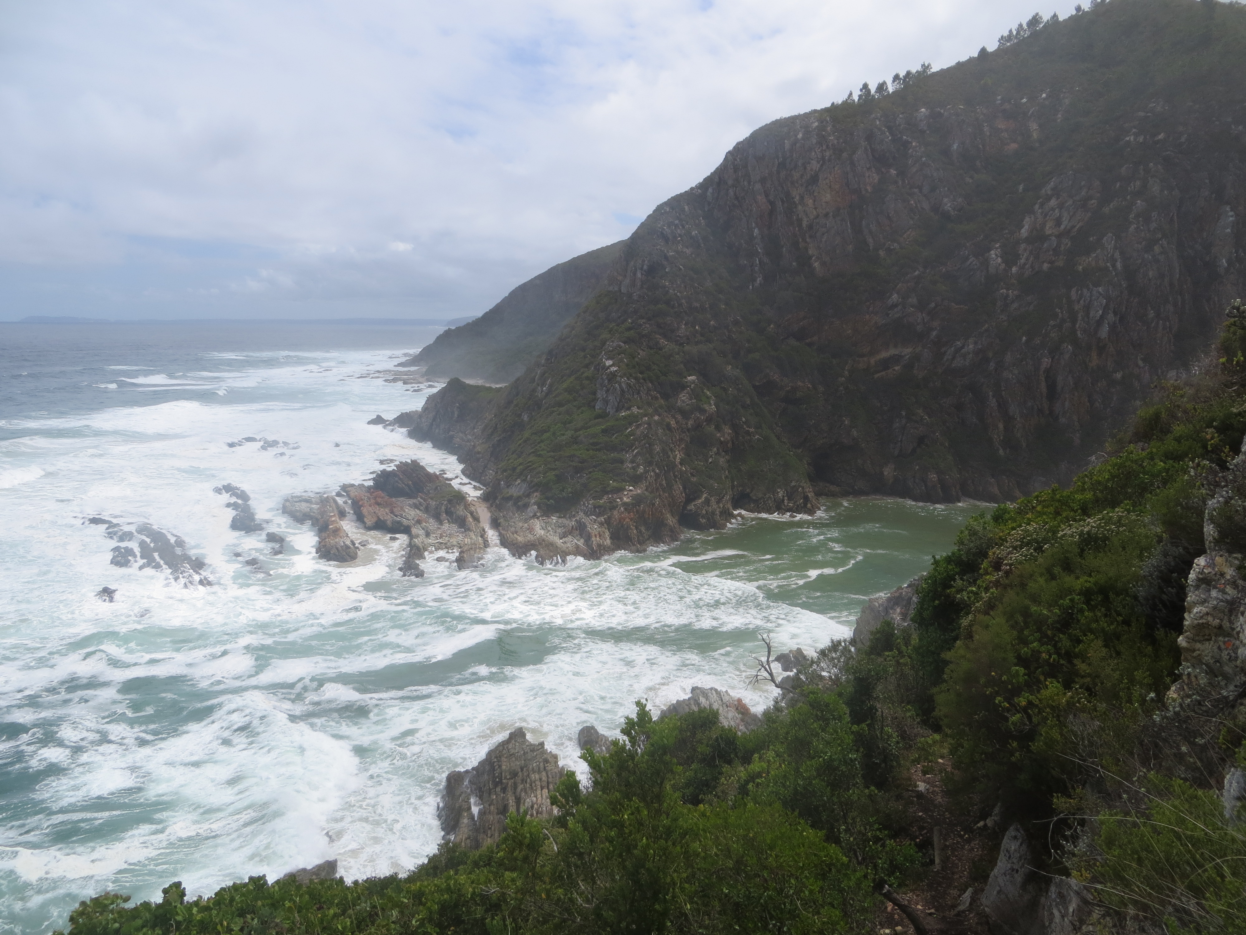
The trail stretches 26 kilometers as the crow flies but 44 kilometers as the hiker walks, and the difference tells you everything about the terrain. The route hugs the coastline but never in a straight line -- it climbs steeply through indigenous forest, drops to boulder-strewn beaches, and forces crossings of tannin-stained streams the color of dark rooibos. The total elevation gain over five days is nearly 3,000 meters, distributed unevenly across stages that range from a gentle 4.8-kilometer opening day to a grueling 13.8-kilometer fourth day with 1,905 meters of vertical change. Day four is the one hikers talk about most, with nearly a kilometer of total climbing and the infamous Bloukrans River crossing, which at high tide can require swimming with your pack held overhead.
Forest, Fynbos, and Tidal Pools
The vegetation shifts constantly along the route, and with it, the light and sound. Dense gallery forest closes overhead in the river valleys, muting the crash of surf and replacing it with birdsong and the drip of moisture from fern fronds. On the ridges, the canopy gives way to fynbos -- low, aromatic scrubland blooming with wildflowers in season. Open rocky sections near the sea offer tide pools and the occasional glimpse of dolphins working the nearshore current. The entire trail lies within the Tsitsikamma National Park, which protects an 80-kilometer strip of coastal mountains, forest, and beaches. The park's marine reserve extends 5.5 kilometers offshore, making the waters below the trail among the most protected in South Africa.
Huts with a View
Each night on the trail ends at one of four hut complexes: Ngubu after the easy first day, Scott or Oakhurst in the middle stretch, and Andre near the Klip River before the final push to Nature's Valley. The huts are simple but well-positioned -- Oakhurst sits at the Lottering estuary, Andre overlooks a rocky cove where sunsets turn the sandstone gold. There are bunks, water, and basic cooking facilities, but no electricity. Hikers carry their own food, sleeping bags, and stoves. The limitation on hut capacity is what creates the booking frenzy: only 12 hikers can start the trail each day, which means the wilderness never feels crowded. On a five-day stretch, you may encounter no one beyond your own group and the occasional otter slipping between the rocks at a river mouth.
The Otters You Might Not See
The Cape clawless otter that gives the trail its name is more often heard than seen -- a splash in a tidal pool, a whistle from the rocks at dusk. These are Africa's largest freshwater otters, adapted to both river and coastal environments, feeding on crabs, fish, and octopus. They are present throughout the Tsitsikamma coast but shy enough that many hikers complete the trail without a confirmed sighting. Those who do spot one typically see it at dawn or dusk near a river mouth, where the tannin-dark freshwater meets the sea. The trail's other wildlife is more conspicuous: baboons on the ridges, bushbuck in the forest understory, and overhead, the Knysna lourie flashing green and crimson as it moves between yellowwood canopies.
Arriving at the Lagoon
The final day brings hikers down through the De Vasselot section of the park to Nature's Valley and the Grootrivier lagoon. After four days of climbing and descending, the trail's conclusion feels almost gentle -- a 9.8-kilometer walk that descends to sea level and ends at the lagoon's quiet water. The contrast with the trail's wilder stretches is deliberate: Nature's Valley is a village of one shop and one restaurant, surrounded by national park, where the only way to get around is on foot. Hikers who have spent nearly a week navigating river crossings and sleeping in huts find themselves standing on a beach covered entirely in sea-smoothed cobbles, looking back along a coastline that took five days to traverse but that, from here, appears to fit within a single glance.
From the Air
Coordinates: 34.02S, 23.88E (trail midpoint). The Otter Trail runs along the Tsitsikamma coast from Storms River Mouth (34.02S, 23.90E) to Nature's Valley (33.98S, 23.56E). From the air, the trail is visible as a narrow corridor along the coastal cliffs between dense forest and ocean. Best viewed at 2,000-4,000 ft. Nearest airports: George (FAGE), approximately 130 km west; Port Elizabeth (FAPE), approximately 180 km east. The Storms River suspension bridge and Bloukrans Bridge are visible navigation landmarks.