Oud Haerlem Castle
For nearly seven decades, archaeologists believed they had found Oud Haerlem Castle. Jaap Renaud's trenches, dug into a Heemskerk field in the early 1960s, had exposed a rectangular ruin with round towers - exactly the kind of fortress you would expect a count of Holland to have built. Then in 2019, surveyors swept the surrounding pasture with ground-penetrating radar and electromagnetic instruments, and the soil began to talk back. There was another castle out there, hidden under the grass. Bigger. Much bigger.
A Castle Twice the Size of Anyone's Expectations
The structure that radar revealed measured 45 by 45 meters - a square keep roughly twice the footprint of Muiden Castle and significantly larger than Ammersoyen, Medemblik, or Helmond. Inside its walls, magnetometry traced the ghost of buildings ranged along all four sides. By the time the 2021 final report was published, the conclusion was unavoidable: the rectangular ruin Renaud had dug in the 1960s was only the outer bailey. The real castle had been waiting beside it the whole time, its outline preserved in the laser scans of the Actueel Hoogtebestand Nederland. Pottery placed its construction in the mid-thirteenth century, which pushes the appearance of the great square castle in Holland back to before Floris V even took his throne.
Why So Many Castles Here
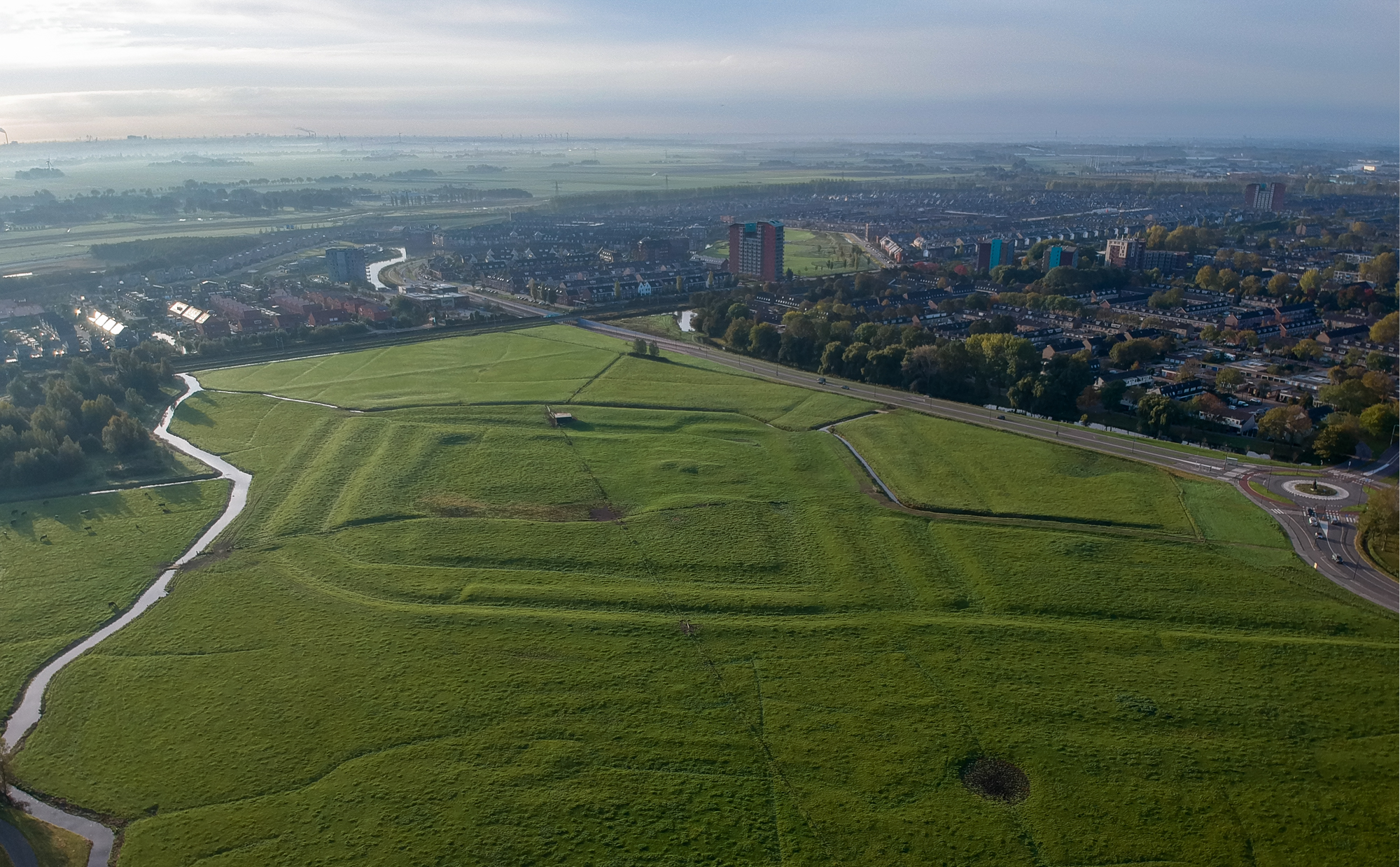
Stand on the site today and the landscape feels unremarkable - polder fields, the suburbs of Heemskerk creeping in from the west, the IJmuiden steelworks smoking on the horizon. In the thirteenth century it looked nothing like this. The IJ pushed deep inland, continuing as the Wijkermeer, and only a narrow ribbon of dune and dry ground connected the parts of Holland that lay north and south of the water. The counts of Holland turned that bottleneck into a defensive line. Within three kilometers of Oud Haerlem stood Assumburg, Poelenburg, and Marquette. Anyone marching south from West Friesland had to run a gauntlet of stone. Oud Haerlem was the largest link in that chain.
Moats Within Moats
What made the castle truly formidable was not its walls but the water around them. Investigators found an eight-shaped moat that wrapped the main keep and outer bailey together, then a second complete moat outside that, with a narrow strip of land sandwiched between. On the south, west, and east sides the pattern repeated again. To reach the inner gate, an attacker would have to cross three to five moats in succession. Seen from the air, the rings make the site look less like a Dutch country estate and more like a Roman legionary camp. The earthworks are still visible on the ground - subtle, but unmistakable once you know where to look.
Eleven Months Under the Trebuchets
The castle's owners, the Polanen family, backed the wrong faction. When William V of Bavaria returned to Holland in February 1351, he started his Hook and Cod wars campaign by smashing his enemies' strongholds. Most fell quickly. Oud Haerlem held out for an estimated eleven months. The besiegers brought blijdes - the great counterweight trebuchets that had reshaped European siegecraft - and battered the walls until an assault finally took the place. Then they tore it down. The ruins outlasted the war by centuries, used as a quarry whenever a nearby church needed dressed stone. In 1866 a substantial portion was carted off to restore Brederode Castle.
The Treasure Renaud Refused to Reveal
Jaap Renaud, the archaeologist who first dug here, distrusted real estate developers more than he distrusted academic rivals. In the early 1960s he unearthed fifteen finely worked bronze objects - still the largest medieval bronze hoard ever found in the Netherlands - and refused to record the exact find spot, fearing looters. The location was only recovered from his private archive after his death in 2007. His caution was vindicated. In the 1990s, even with the site designated a national monument, the municipality of Heemskerk approved plans to build a golf course over it. The 79-year-old Renaud personally intervened to stop them. The fields where the radar finally found the missing castle remained intact, waiting for technology to catch up to his suspicions.
From the Air
Coordinates 52.500N, 4.688E, on the eastern edge of Heemskerk just west of Amsterdam. The site is roughly 11 km southwest of Schiphol (EHAM) and 6 km east of the IJmuiden steel works on the North Sea coast. Best viewed at 2,000-3,000 ft on a clear day; the concentric moat earthworks are visible as subtle parallel rings in the pasture, especially in low-angle morning or evening light. Assumburg Castle sits 400 m to the north-northwest, still standing, providing a useful navigation reference.