Oulanka National Park
The Karhunkierros trail does not ease you in. From the trailhead at Hautajärvi, the first wilderness hut is 15 kilometers of walking away—through boreal forest, across rivers, over terrain that earns its Finnish name: the Bear's Trail. At 80 kilometers end-to-end, Karhunkierros is the most famous long-distance hike in Finland, and its home in Oulanka National Park sits right on the Arctic Circle, pressed against the Russian border. Despite this remoteness—or because of it—Oulanka is one of Finland's most visited national parks, drawing hikers, canoeists, and winter adventurers who come for the rivers, the red rocks, and the feeling of genuine wilderness.
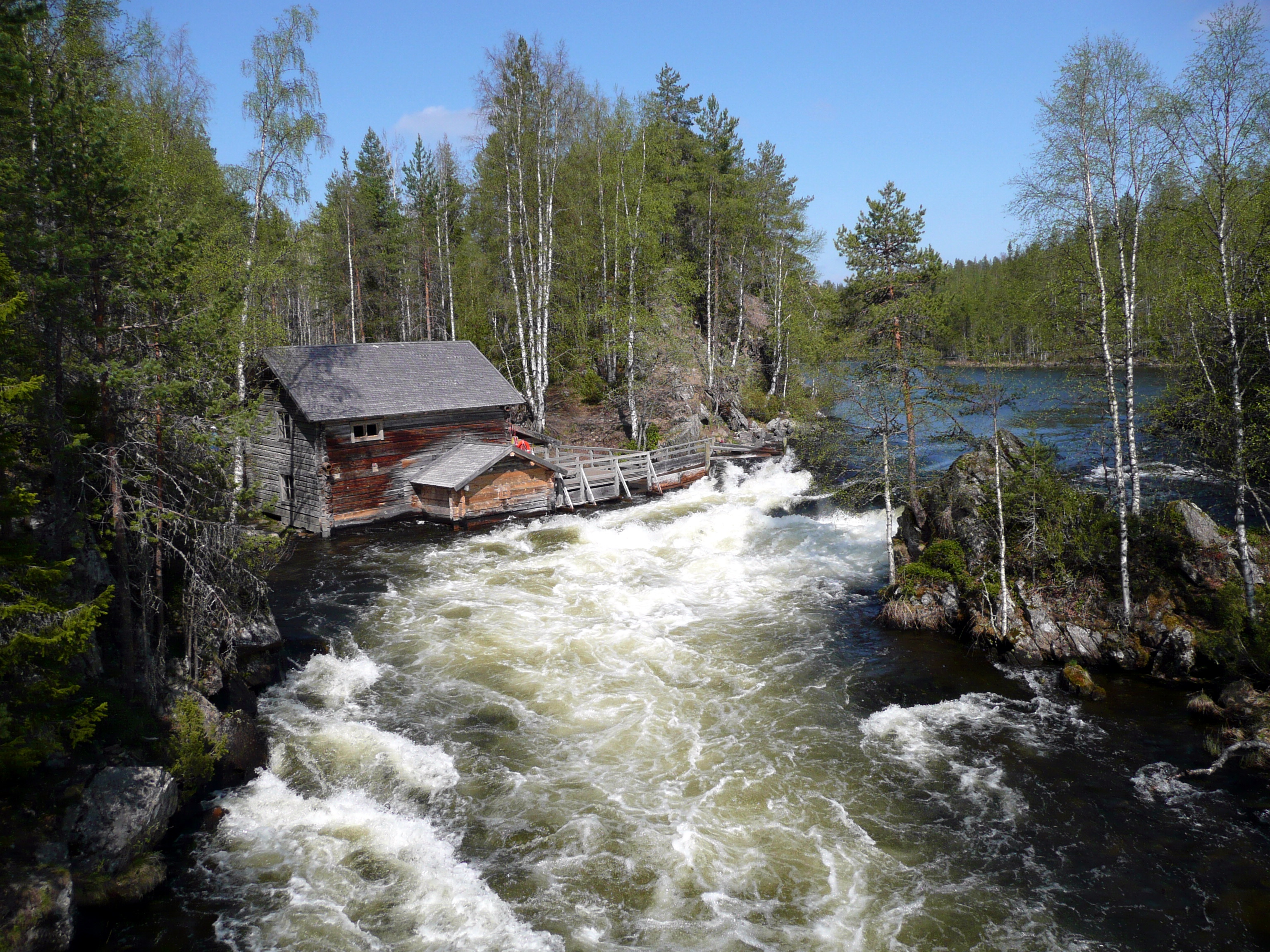
Rivers Through Red Stone
Oulanka's landscape is defined by its rivers. The Oulanka river is the largest, but several other waterways cut through the park, carving small gorges and rapids through surprisingly colorful rock. The famous red rocks near the visitor center—featured on the short Hiiden Hurmos trail—are the park's geological calling card, iron-rich outcrops that glow against the green forest. Altitude differences in the park are modest, but rocky outcrops and small hills rise above the river valleys, offering views across unbroken forest that stretches to the Russian border. Across that border lies Paanajärvi National Park, forming a continuous protected wilderness, though crossing—or even approaching—the border requires special permits.
Walking the Bear's Trail
Most hikers tackle Karhunkierros in three or four days, sleeping in the open wilderness huts that dot the trail. These huts are free, maintained by park staff, and stocked with firewood, but they offer no bedding and no electricity. In summer, they fill up—the Finnish solution is to either walk faster and arrive first, or carry a tent. The full Iso Karhunkierros runs from Hautajärvi to the ski resort of Ruka, climbing Valtavaara hill at its southern end. For those with less time, the 12-kilometer Pieni Karhunkierros loop from Juuma takes a single day and passes through some of the park's most dramatic scenery, including the thundering Jyrävä waterfall. Two short sections are even wheelchair-accessible, including the trail from Hautajärvi to a lean-to shelter on the Koutajoki river.
Water and Winter
Canoeing is the park's other signature activity. Two designated stretches of the Oulanka river offer paddling routes: the 25-kilometer run from Kiutaköngäs to Jäkälämutka, and the shorter, more challenging 13 kilometers from Savilampi to the visitor center. Some wilderness huts are reachable only by boat. In winter, the rivers freeze and become snowmobile highways. Cross-country skiing follows the trail from the visitor center to Juuma, with a winter-only "Wilderness Track" variant that reveals the park from a different angle. The snow does not disappear until June, and the maximum depth averages 85 centimeters. Snowshoeing is popular on the Hiiden Hurmos trail, and fat bikes are permitted on the multi-purpose winter routes.
Arctic Seasons
Oulanka's relationship with light is extreme. From May to August, night never properly arrives—the sun hovers at the horizon, casting long golden light across the rivers. In December, the equation reverses: daylight is measured in minutes, and the park becomes a world of blue twilight and lantern-lit trails. Summer is the busiest season, but late May offers the meltwater landscape in solitude, and early autumn brings the ruska—the Lapland fall colors—with the bonus of vanished mosquitoes. Winter hiking demands serious preparation: sleeping bags rated well below minus twenty, proper layered clothing, and the understanding that some parts of the trail are far from any road, with no phone coverage in the valleys.
Getting There Is Part of the Story
Reaching Oulanka requires commitment. The nearest airport is in Kuusamo, with flights mostly from Helsinki. From there, a local "Karhunkierros bus" runs to the trailheads in summer, but outside June through August, public transport thins dramatically. Overnight trains from southern Finland reach Oulu or Kemijärvi, with coach connections onward to Kuusamo. The park connects to the broader UKK trail network: southward toward Riisitunturi and Syöte national parks, and northward through Salla to Urho Kekkonen National Park. The remoteness filters visitors, and those who make the effort find a park that feels earned rather than given—a stretch of Arctic river valley where the wilderness is genuine and the bear, whose trail you are walking, is not entirely metaphorical.
From the Air
Located at 66.37°N, 29.34°E in northeastern Finland, straddling the Arctic Circle near the Russian border. The Oulanka river system is visible as a winding corridor through boreal forest. The ski resort village of Ruka lies to the south. Recommended viewing altitude: 5,000–10,000 ft AGL to trace the river valleys and trail system. Nearest airport: Kuusamo (EFKS), approximately 50 km south. Paanajärvi National Park (Russia) is visible across the border to the east.