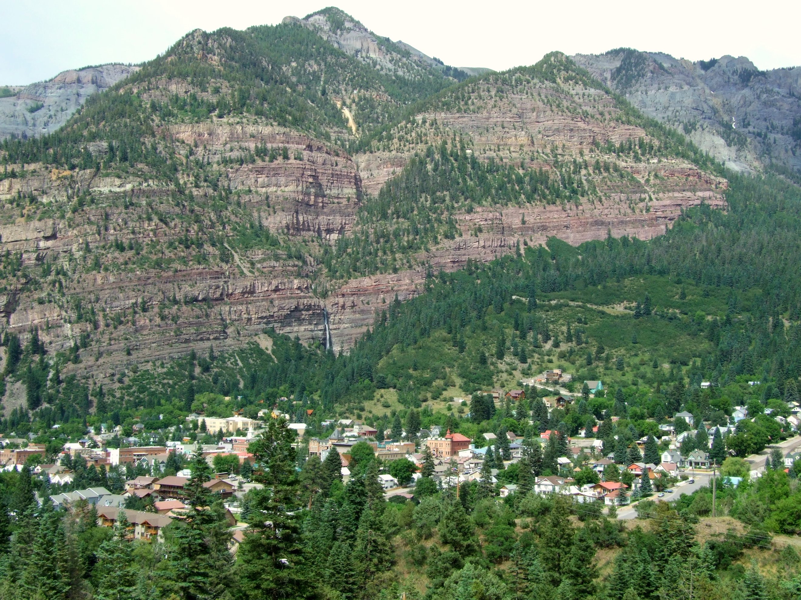
Ouray, Colorado
Ayn Rand later admitted that the secret mountain valley in Atlas Shrugged -- Galt's Gulch, the hidden utopia where the world's productive minds withdrew from a collapsing civilization -- was inspired by a real place: Ouray, Colorado. It is easy to see why. The town of 898 people sits at the narrow head of a valley enclosed on three and a half sides by steep mountains in the San Juan range, accessible by a single paved road. The Ute people knew this land long before prospectors arrived in 1875, and the town was named for Chief Ouray, a Ute leader who navigated the impossible politics between his people and the expanding United States. The name stuck through several changes; the town was incorporated on October 2, 1876.
The Camp Bird and a Million Ounces
Ouray's mining history pivots on one man and one mine. In 1877, William Weston and George Barber discovered the Gertrude and Una gold veins in Imogene Basin, six miles south-southwest of town. Thomas Walsh acquired both veins and all the open ground nearby, then in 1897 opened the Camp Bird Mine. He added a twenty-stamp mill in 1898 and a forty-stamp mill in 1899. By 1902, the mine had produced nearly 200,000 ounces of gold, at which point Walsh sold to Camp Bird, Ltd. By 1916, the company had extracted over one million ounces of gold. At its peak, Ouray had more than 30 active mines. Over its full lifespan from 1896 to 1990, the Camp Bird produced approximately 1.5 million troy ounces of gold and 4 million troy ounces of silver, making it the second-largest gold mine in Colorado.
The Railroad That Came and Went
The Denver and Rio Grande Railway reached Ouray on December 21, 1887, connecting the remote mining town to the outside world. But unlike the Durango-Silverton line to the south, Ouray's railroad did not survive the transition from mining to tourism. As automobiles and trucks replaced rail for both passengers and freight, ridership dropped steadily. The last regularly scheduled passenger train ran on September 14, 1930. The line between Ouray and Ridgway was officially abandoned on March 21, 1953. What remains is Main Street, registered as a National Historic District, where most buildings date from the late nineteenth century. The Beaumont Hotel and the Ouray City Hall and Walsh Library are individually listed on the National Register of Historic Places, while the Ouray County Courthouse, St. Elmo Hotel, and Wright's Opera House stand within the district.
Frozen Waterfalls in the Gorge
Ouray reinvented its winter economy through ice. The Ouray Ice Park, the world's first ice climbing park, stretches along more than a mile of the Uncompahgre Gorge, where dozens of frozen waterfalls ranging from 80 feet to over 200 feet high are farmed each winter using a sprinkler system developed and maintained by volunteers and funded by donations from local businesses, gear manufacturers, and climbers. The park is free and open to all, attracting climbers from around the world. The annual Ouray Ice Festival is a weekend-long event of competitions, exhibitions, and instruction featuring many of the world's top ice climbers. The economic impact has been transformative: hotels and restaurants that once shuttered for winter now stay open year-round to serve the climbing community.
Hot Springs and the Million Dollar Highway
Five developed hot springs dot Ouray and nearby Ridgway, offering thermal pools and vapor caves. The Ouray Hot Springs is the largest facility, with multiple pools drawing from natural geothermal sources. Box Canyon Falls crashes at the town's southwest edge. But Ouray's most famous feature may be the road that leads away from it. The stretch of U.S. Highway 550 running south from Ouray to Silverton is the Million Dollar Highway, frequently called one of the most beautiful and most dangerous roads in Colorado, with sharp turns, steep ledges, and a notable absence of guard rails. Recording artist C. W. McCall -- who served as Ouray's mayor from 1986 to 1992 -- helped make the nearby Black Bear Road famous with a song that borrowed the phrase from a roadside sign: you don't have to be crazy to drive this road, but it helps.
The Gulch That Inspired a Novel
Ouray's setting as a hidden valley in the Rockies, reachable only by one road through mountain passes, has drawn storytellers for decades. Beyond Rand's Atlas Shrugged, Chuck Wendig chose Ouray as the destination for survivors rebuilding civilization in his novel Wanderers, and the sequel Wayward is set largely in the town. Netflix used a photograph of Ouray in the opening credits of The Ranch. Major League pitcher Smoky Joe Wood grew up here. The town of fewer than 900 people occupies a space in American culture larger than its population would suggest, perhaps because Ouray embodies something elemental: a place so enclosed by mountains that it feels protected from the outside world, a valley that could shelter anything you wanted to build inside it.
From the Air
Ouray sits at approximately 38.03N, 107.67W at roughly 7,800 feet elevation in a narrow valley enclosed on three and a half sides by steep San Juan Mountain peaks. The town is visible as a small settlement at the head of the Uncompahgre River valley. The Uncompahgre Gorge cuts through the south side of town -- the Ice Park is located here. US-550 is the only paved road in or out, running north to Montrose and south over Red Mountain Pass (11,000+ ft) toward Silverton. Nearest airport with scheduled service is Montrose Regional Airport (KMTJ), approximately 36 miles north. The Million Dollar Highway section begins immediately south of town. Yankee Boy Basin and the Camp Bird Mine area are visible to the southwest.