Owyhee Dam
President Herbert Hoover could not attend. On July 17, 1932, with the Great Depression grinding across America, he sent Secretary of the Interior Ray Lyman Wilbur to deliver his message at the dedication of what was then the tallest dam of its type in the world. The structure rising from the remote canyon of the Owyhee River in Eastern Oregon represented something beyond concrete and steel - it was proof that ambitious engineering could still proceed even as breadlines lengthened in the cities. Within two years, the techniques pioneered here would be scaled up for the far more famous Hoover Dam on the Colorado River. But first, there was this: a 417-foot wall of concrete holding back the waters of a river named for three Hawaiian fur trappers who had vanished in this country more than a century before.
Blueprint for a Giant
The Owyhee Dam did not spring from barren rock by accident. Frank A. Banks, the engineer who designed it, was perfecting methods that would reshape the American West. His arch-gravity design - a concrete structure that curves upstream to push against canyon walls while using its massive weight to resist water pressure - proved so successful here that he would later apply the same principles to the Grand Coulee Dam on the Columbia River. The dam cost $6 million to build, with the entire reclamation project totaling $18 million. In August 1927, Congress had authorized construction, and workers broke ground the following year. They built on a foundation of massive rhyolite and pitchstone formations adjacent to the Owyhee Mountains, laying thousands of cubic yards of concrete in a canyon so remote that the nearest town, Adrian, barely registers on most maps.
Taming the High Desert
The climate here pushes extremes. The record high reached 112 degrees Fahrenheit in July 2002; the record low plunged to -22 degrees in January 1962. Annual precipitation averages less than 10 inches. Without irrigation, this is sagebrush country, home to jackrabbits and pronghorn but not much else. The dam changed everything. The Owyhee Reservoir behind it holds nearly 1.1 million acre-feet of water, irrigating farmland across Eastern Oregon and neighboring Idaho. The Bureau of Reclamation owns the facility while the Owyhee Irrigation District operates it, maintaining the infrastructure that turned desert into productive agricultural land. In the 1980s, hydroelectric generating capabilities were added, squeezing additional value from water that would flow downstream regardless.
The World Record That Wasn't
For roughly two years, Owyhee Dam held a distinction: tallest dam of its type in the world. The title passed in 1934 when France completed the Lac du Chambon dam at 448 feet, surpassing Owyhee's height. But the engineering legacy proved more durable than any record. The techniques developed here - managing the immense pressures of concrete curing, anchoring to bedrock, designing spillways that could handle catastrophic floods - became standard practice for the massive dam projects that would transform western rivers over the following decades. From 1990 to 1993, the dam underwent extensive remodeling, ensuring its continued service into a new century.
Recognition Long Overdue
The dam stood for 78 years before receiving formal historical recognition. On September 23, 2010, it was added to the National Register of Historic Places as part of the Owyhee Dam Historic District. Haystack Rock Road still crosses the crest, just as it did when the dam was new. The surrounding landscape remains stark and beautiful - the Owyhee Mountains rising to the south, the reservoir stretching eastward into canyon country that looks much as it did when those Hawaiian trappers gave the river its name. The concrete has weathered to a pale gray that almost matches the rhyolite cliffs. Water still flows through the turbines and into the irrigation channels, keeping the high desert green where farms have taken root in soil that would otherwise support only sagebrush.
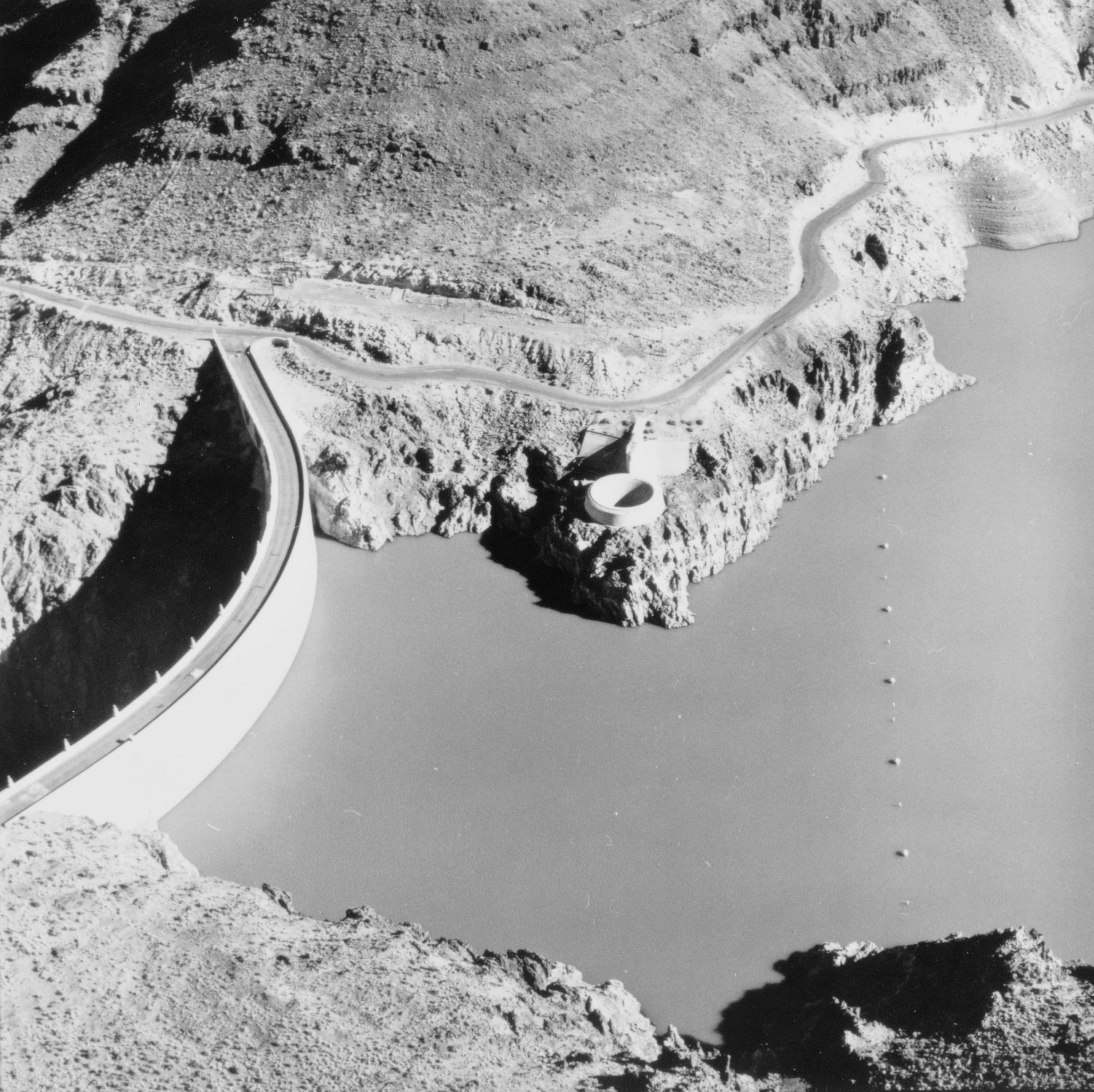
From the Air
Owyhee Dam sits at 43.64N, 117.24W in the remote canyon country of Eastern Oregon near the Idaho border. The reservoir stretches dramatically through desert terrain, making it highly visible from altitude. Best approached from the east following the reservoir's length. The nearest airports include Boise Air Terminal (KBOI) approximately 50 miles northeast, and Ontario Municipal Airport (KONO) about 30 miles north. The dam structure itself is most visible at lower altitudes; the distinctive curved arch shape is apparent from 2,000-3,000 feet AGL.