Oysterville Cemetery
"And the sea gave up the dead." The words from Revelation 20:13 are carved into a marble headstone near the entrance of the Oysterville Cemetery, honoring unknown sailors whose bodies washed ashore from the Columbia River bar -- the stretch of water so lethal it earned the name Graveyard of the Pacific. It is a fitting epitaph for this entire place. Two acres of grass and weathered stone on the Long Beach Peninsula, a quarter mile from the remnants of Oysterville itself, this cemetery holds the compressed history of everyone who tried to make a life on Washington's remote southwest coast: the Indigenous people who lived here for centuries, the oyster-hungry pioneers who arrived in the 1850s, their children and grandchildren, and the anonymous dead that the ocean kept returning to shore.
Before the Town Had a Name
The earliest death date in the cemetery is 1851 -- three years before Oysterville was even founded. That grave belongs to John Carruthers, who was not originally buried here. His brother Roberts later transferred the remains so John could rest alongside their father, mother, and brother. The land itself was owned by F.C. Davis and used informally as a burial ground for decades before the Oysterville Cemetery Association finally purchased the original acre in 1890, paying Davis one hundred dollars for ground that had already absorbed more than thirty years of grief. By then, Oysterville had boomed on the back of its oyster beds, briefly served as the seat of Pacific County, and begun its long, quiet decline.
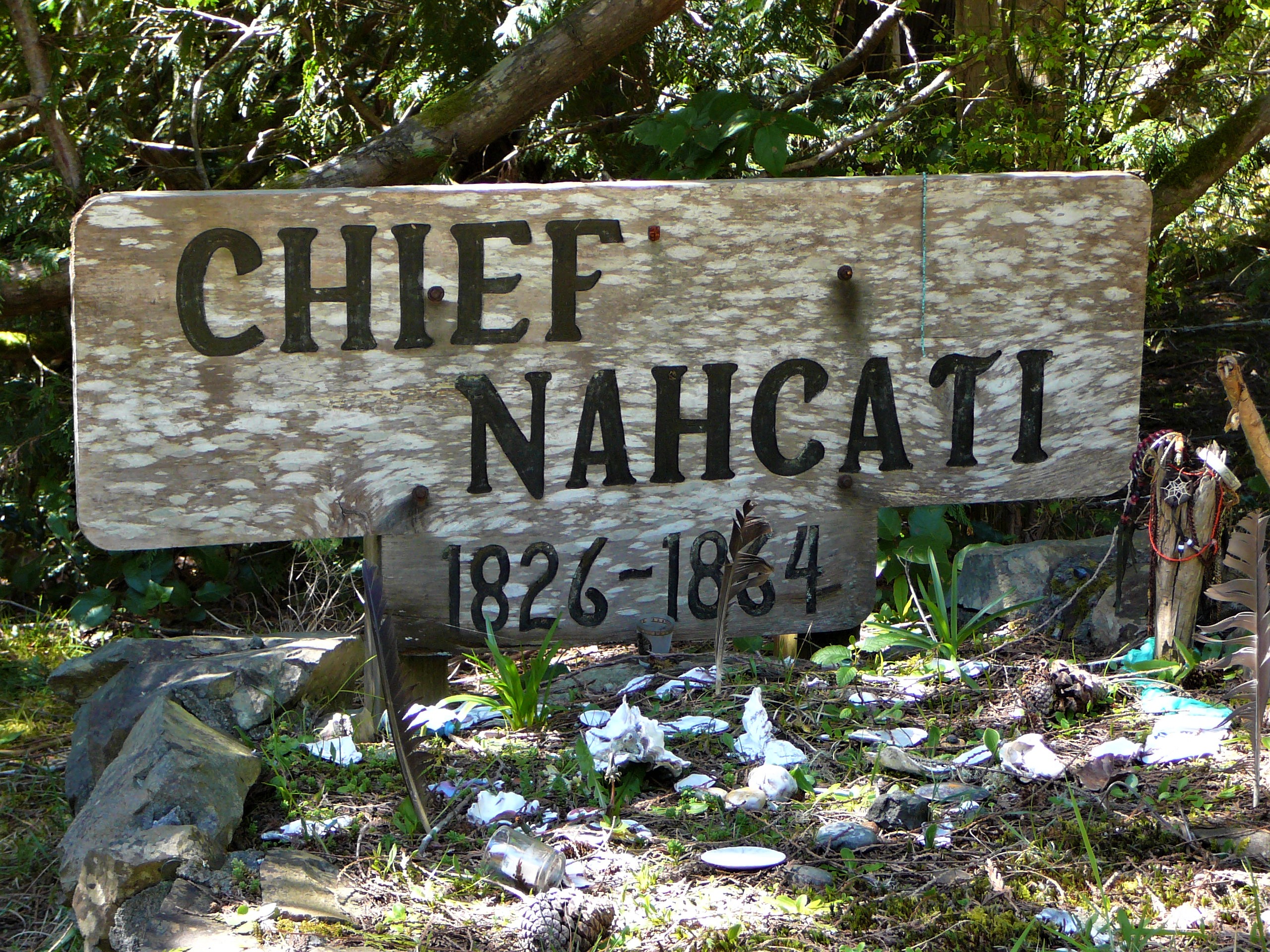
Chief Nahcati and the Shoalwater Bay People
Just inside the cemetery entrance, to the right, stands a memorial to Chief Nahcati, the last Native American chieftain of the Long Beach Peninsula. His presence here is a reminder that this coastline belonged to the Shoalwater Bay Tribe long before any English-speaking settler arrived to harvest its oysters. The headstones tell fragments of that older world. One burial connects to Chief Uhlahnee of the Chinook band at Celilo Falls and Chief Hoqueem of the Quinault Tribe -- bloodlines that reached across hundreds of miles of the Pacific Northwest. The cemetery does not explain these connections in full. It holds them in stone and lets the names do the work, a quiet record of the Indigenous families whose lives were woven into this peninsula long before it had county lines or English place names.
Oyster Fortunes and a County Seat Lost
The founding families buried here rode Oysterville's brief, improbable prosperity. In the 1850s and 1860s, the tiny settlement on Willapa Bay was the center of Washington's oyster trade, its native beds supplying San Francisco's insatiable appetite for shellfish. The town became important enough to be named the seat of Pacific County. But the oyster beds were finite, and the town's fortunes faded. On February 5, 1893, a group from South Bend simply showed up and stole the county records -- books, ledgers, everything -- physically relocating the seat of government. A sign across from the old Oysterville schoolhouse still tells the story. Many of the people involved in that era, on both sides of the county seat war, ended up here in this cemetery, their disputes settled by time.
The Sea's Dead and the Living Volunteers
The memorial to unknown sailors is not a single grave but a recognition of a pattern. The Columbia River bar, where the river's massive current collides with Pacific swells, has claimed more than two thousand vessels and countless lives since the early 1800s. Bodies washed up on the Long Beach Peninsula with some regularity, and when they could not be identified, they were buried here. The Revelation inscription gives them a collective dignity that individual anonymity could not. In 1979, the Espy family -- descendants of the town's founding generation -- donated an additional half acre, expanding the cemetery to accommodate new burials. Today a small volunteer association maintains the grounds, manages records, and coordinates interments through Penttila's Chapel by the Sea. The original linen cemetery map, two feet wide and eight feet long, has been digitized by a modern caretaker who scanned, cleaned, and annotated it section by section -- a quiet act of preservation for a place that holds the peninsula's entire history underfoot.
From the Air
Located at 46.5476N, 124.0335W on the Long Beach Peninsula in Pacific County, Washington. The cemetery sits roughly a quarter mile from the historic core of Oysterville, on the east side of the peninsula along Willapa Bay. From the air, look for the narrow peninsula separating Willapa Bay from the Pacific Ocean. Best viewed below 3,000 feet AGL. Nearest airport: Willapa Harbor Airport (2S1) approximately 20nm northeast. Astoria Regional Airport (KAST) is roughly 25nm south across the Columbia River mouth.