Ozegahara
Six thousand years of patient accumulation lie beneath your feet on the boardwalks of Ozegahara. Layer upon layer of compressed sphagnum moss, dead roots, and organic sediment have built this peat bog centimeter by centimeter since the end of the last glacial period, filling a volcanic basin with a living sponge of earth and water that now stretches eight square kilometers between two of Honshu's most imposing peaks. This is Japan's largest highland marsh, a Ramsar-designated wetland sitting at 1,400 meters above sea level, and a place where the seasons announce themselves not with a calendar but with successive waves of wildflowers so vivid they look painted onto the landscape.
Born from Fire and Ice
Ozegahara owes its existence to Mount Hiuchigatake, the 2,356-meter volcano that looms to the north. Ancient eruptions from Hiuchigatake sent lava flows and debris across the drainage of what had been a mountain valley, damming its streams and creating a basin with no outlet. Water pooled, sediment collected, and sphagnum moss began its slow colonization. Research on the peat deposits shows that the westernmost portion of the marsh formed first, during the transition from the late glacial period to the early Holocene. Slope mires covering alluvial fans at the base of surrounding mountains followed around 9,000 years ago. The central basin below 1,405 meters filled primarily from river backmarshes beginning around 8,000 years ago. Mount Shibutsu, rising to 2,228 meters on the south side, completed the geological parentheses -- two volcanoes cradling a bog between them.
A Calendar Written in Petals
The marsh's floral display follows a strict seasonal choreography that draws botanists and hikers alike. Late May brings the mizu-basho, white skunk cabbage whose broad leaves and spathe-wrapped flowers carpet the wetland in green and white as the snowmelt recedes. By late June, watasuge -- cotton grass -- erupts in wispy white tufts that make the bog look dusted with fresh snow. July belongs to the nikko-kisuge, yellow alpine day lilies that turn entire sections of the marsh into fields of gold. The bog asphodel follows in August with its buttery spikes. In total, more than 900 species of vascular plants have been cataloged across the Oze wetlands. The marsh is also a designated Special Natural Monument of Japan, a recognition reserved for the country's most ecologically irreplaceable landscapes.
Walking on Water
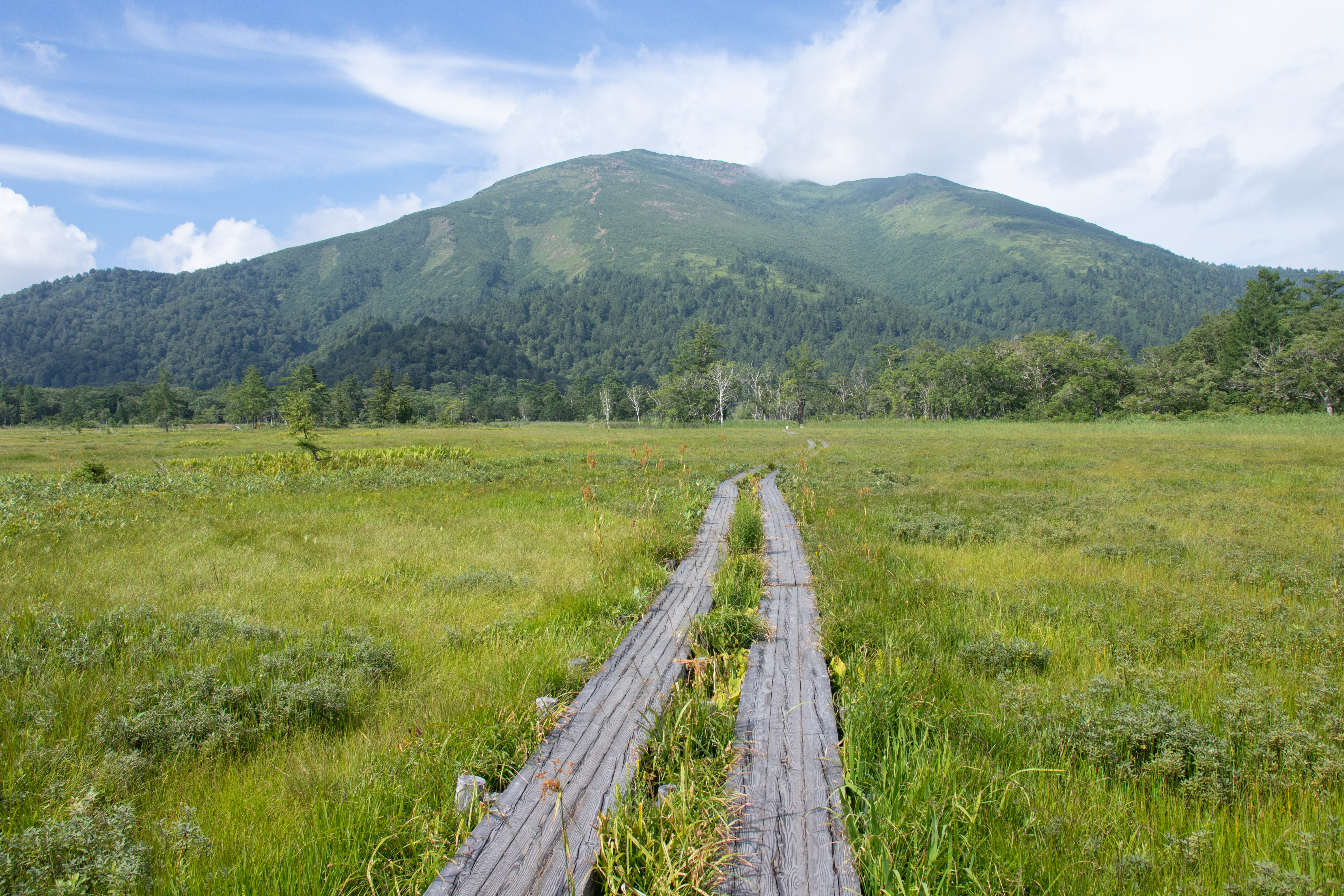
Ozegahara's boardwalks are one of Japan's most iconic hiking experiences, but they serve a purpose beyond convenience. The peat beneath the marsh is saturated and extraordinarily fragile -- a single footstep off the planks compresses centuries of accumulated growth and leaves a scar that takes decades to heal. The wooden walkways wind for kilometers through the heart of the wetland, hovering just above the waterline, with Mount Hiuchigatake filling the northern horizon and Mount Shibutsu anchoring the south. The flat boardwalk sections are gentle, almost meditative, but reaching them is another matter entirely. There are no roads into Ozegahara. Hikers descend from mountain passes on steep trails, the most popular route beginning at Hatomachi Pass and requiring a full-day round trip of six to eight hours. The isolation is a feature, not a flaw -- it keeps visitor numbers manageable and preserves the hush that settles over the marsh at dawn.
The Sound of Conservation
Ozegahara is inseparable from the broader story of Oze National Park and the conservation battles that saved it. Plans for a hydroelectric dam emerged as early as 1903, which would have drowned the entire basin under a reservoir. Local opposition, led across four generations by the Hirano family and supported by scientists like botanist Hisayoshi Takeda, blocked every attempt to develop the marsh -- dams, roads, power lines -- for over a century. The result was Japan's first genuine grassroots conservation victory, and it turned Oze into a symbol of environmental awareness that resonates far beyond the hiking community. The songwriter Etsuko Nakanishi immortalized the marsh in her 1949 composition "Natsu no Omoide" (Summer Memories), a song about mizu-basho blooming in the mist that became so widely taught in Japanese schools that the melody is nearly universal. For many Japanese, the word "Oze" evokes the song before the place -- which is, perhaps, the most effective form of conservation there is.
From the Air
Located at 36.93N, 139.23E in the mountains of central Honshu, Japan. Ozegahara sits at approximately 1,400 meters elevation in a basin between Mount Hiuchigatake (2,356m, north) and Mount Shibutsu (2,228m, south). From above, the marsh appears as a distinctive flat, pale-green expanse surrounded by dense forested mountain slopes -- unmistakable against the rugged terrain. Nearest airports: Niigata Airport (RJSN) approximately 100km to the northwest, Fukushima Airport (RJSF) approximately 80km east. Terrain is mountainous with peaks exceeding 2,000 meters on all sides; maintain safe altitude margins. Summer afternoons bring convective cloud buildup over the ridgelines. Best aerial visibility in morning hours.