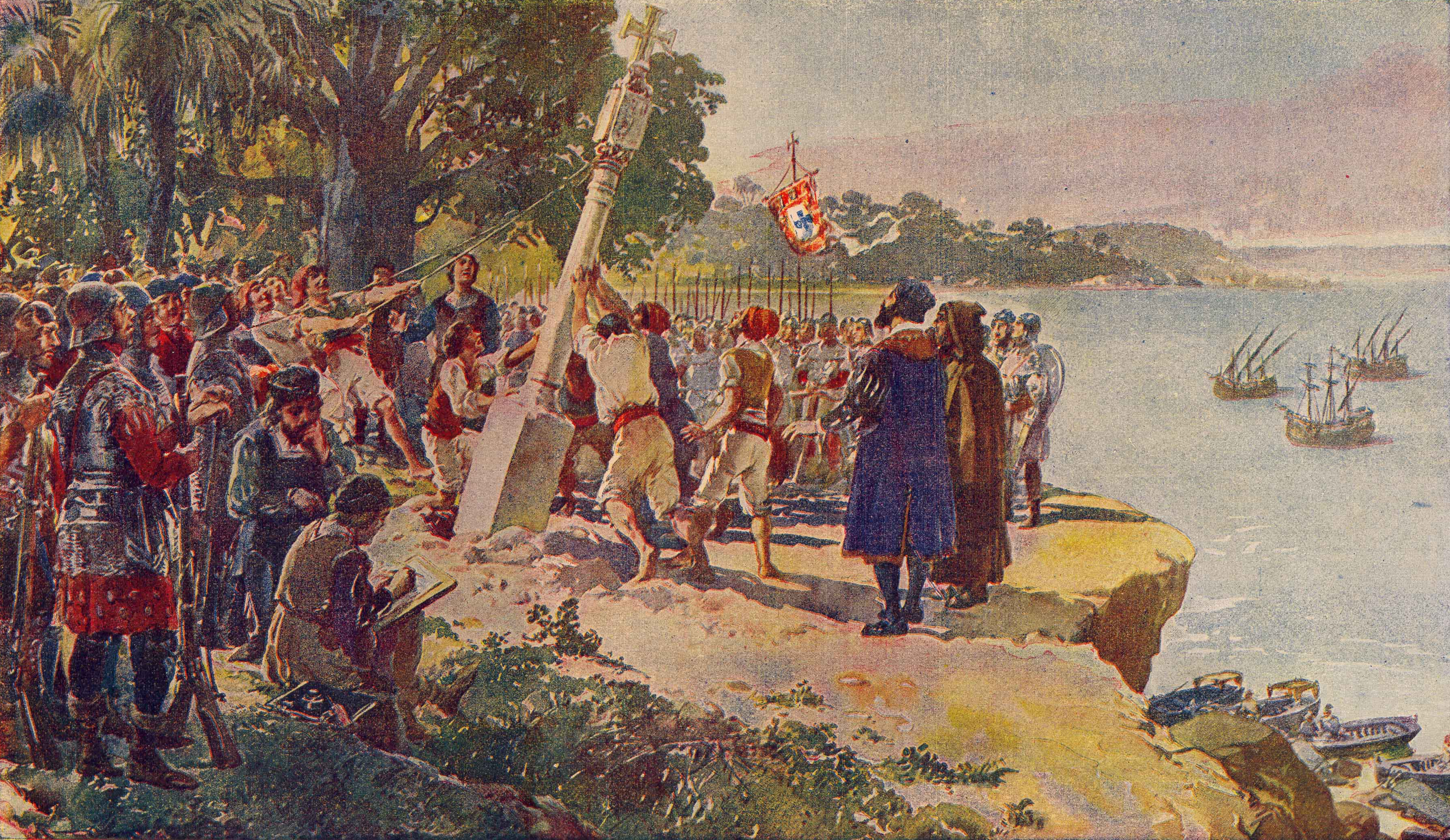
Padrao
Somewhere in a Lisbon workshop in the early 1480s, stonemasons carved a pillar from local limestone, topped it with a cross and the royal coat of arms of King Joao II, and loaded it onto a ship bound for waters no European had charted. Diogo Cao would carry this pillar -- and several others like it -- down the west coast of Africa, planting them on headlands and river mouths as he went. Each one was a padrao: a stone claim staked in the earth of a continent that belonged to someone else. These markers were Portugal's way of writing ownership onto the landscape, and their story stretches from the mouth of the Congo River to the coast of South Africa, from East Africa to Indonesia.
Stone Flags on Foreign Shores
The earliest Portuguese explorers marked their landfalls with wooden crosses, but the tropics devoured wood quickly -- rot, insects, and weather reduced them to splinters within years. King Joao II solved this problem by ordering stone padroes carved before the voyage and carried in the hold. Diogo Cao was the first to plant them, beginning with his expedition of 1482 to 1484. He placed pillars at points along what is now Gabon and Angola. The first went up at the mouth of the Congo River. On his second expedition (1484-1486), he erected one on the headlands at Cabo Negro in Angola, inscribed with text declaring Portuguese sovereignty, and another at Cape Cross in present-day Namibia. These were not modest markers. Standing several feet tall, topped with the cross of Christ and the Aviz coat of arms, they were designed to be seen and understood -- by Portuguese sailors who might follow, and by any rival European power that might arrive to challenge the claim.
From the Congo to Calicut
Other explorers followed Cao's example and extended the chain of padroes across the globe. Bartolomeu Dias placed one at Kwaaihoek on South Africa's Eastern Cape coast in 1488, marking the site of his most easterly landfall after becoming the first European to round the Cape of Good Hope. A decade later, Vasco da Gama erected a padrao at Malindi in East Africa before crossing the Indian Ocean to Calicut -- the Vasco da Gama Pillar still stands there today -- the only padrao erected along the African coast to survive in its original form, though badly weathered and enclosed in a protective concrete cone since 1973. In 1522, the mariner Henrique Leme raised a padrao at Sunda Kalapa, the main port of the Sunda Kingdom, in what is now Jakarta, Indonesia. That stone was lost for nearly four hundred years before being rediscovered in 1918; it is now exhibited at the National Museum of Indonesia. The padroes trace the entire arc of Portuguese maritime expansion, from tentative coastal probes to the establishment of a global trading empire.
Found in Pieces
Time and human hands were not kind to the padroes. Many were toppled, broken, or buried. In the 1930s, the South African historian Eric Axelson discovered the fragments of Bartolomeu Dias's 1488 padrao at Kwaaihoek -- it had fallen, or been pushed, off the top of the promontory and lay shattered in the gullies below. Axelson recovered the pieces and painstakingly reconstructed the monument; the reassembled original now stands in the William Cullen Library at the University of the Witwatersrand in Johannesburg, while a replica marks the original site. In the 1950s, Axelson led further expeditions that located additional fragments, identifying them by their distinctive Portuguese limestone -- a material found nowhere in Africa, unmistakable evidence of European manufacture. The Lisbon Geographic Society managed to restore three of Diogo Cao's padroes and one of Dias's in the twentieth century.
Sovereignty in Stone
The padroes were legal instruments as much as they were monuments. Under the Treaty of Tordesillas and the papal bulls that preceded it, the physical act of marking land with the royal arms constituted a formal claim of possession. Each padrao was both a navigational marker for future Portuguese voyages and a legal assertion that this coast, this river mouth, this headland belonged to the Portuguese crown. The people who already lived on these coasts had no voice in the matter. The stone pillars speak to a particular European worldview of the fifteenth and sixteenth centuries -- one in which a carved cross and a coat of arms could override centuries of indigenous habitation. Today the surviving padroes and their replicas are treated as historical artifacts rather than active claims, but they remain tangible reminders of how imperial power was projected across oceans and inscribed into the physical world.
From the Air
The article coordinates at 6.08S, 12.33E place this near the mouth of the Congo River in Angola, where Diogo Cao erected the first stone padrao in 1482. The wide estuary of the Congo is a dramatic landmark visible from high altitude. Other padrao sites stretch along the African coast from Gabon to South Africa's Eastern Cape. Nearest airport: Soyo Airport (FNSO) in Angola, approximately 15 km southeast. The coast of northern Angola is relatively flat with mangrove-lined estuaries.