Pancake Rocks and Blowholes
Thirty million years ago, nearly all of Zealandia lay beneath shallow tropical seas. Countless marine creatures lived and died above a slowly rising seafloor, and their shells drifted downward like snow, settling into layers of almost pure calcium carbonate. The result of that quiet accumulation now stands at Dolomite Point on New Zealand's West Coast: pale limestone cliffs carved into formations so precisely layered they look like stacks of giant pancakes, each slab separated by thin dark seams of softer stone. When the Tasman Sea surges through the caverns below at high tide, it erupts through vertical blowholes in roaring columns of salt spray, a reminder that the same ocean that built these rocks is still reworking them.
Shells All the Way Down
The Pancake Rocks began forming during the Oligocene period, between 22 and 30 million years ago, when a cluster of low-lying islands sat in warm coastal waters off what is now the West Coast. Marine organisms thrived in extraordinary diversity, and as they died their shells accumulated on the seafloor alongside fine sand and mud eroded from the islands. Over millions of years, this shell debris compacted into a thick deposit of nearly pure calcium carbonate. Then around 25 million years ago, the Kaikoura Orogeny began lifting the earth's crust, building the Southern Alps and burying the older shell layers under massive deposits of sand and mud. The immense pressure squeezed water from the sediment and cemented it into limestone. What gives the Pancake Rocks their distinctive layered appearance is the alternation between hard limestone bands and softer, more easily eroded material. Rain, waves, and chemical dissolution have etched away the weaker layers, leaving the harder slabs protruding like the edges of a colossal deck of cards.
When the Sea Exhales
The blowholes are the real performance. During incoming swells, particularly at high tide, the Tasman Sea forces itself into a network of caverns and surge channels carved beneath the headland. Compressed by narrowing passageways, the water finds vertical shafts and explodes upward in plumes that can reach several meters above the cliff top. The effect is visceral: a deep, percussive boom as the wave enters the cavern, a moment of pressurized silence, then the explosive release of spray. On calm days, the blowholes merely gurgle and sigh. But in heavy seas, the whole headland seems to breathe, with saltwater mist drifting across the walkways and the sound of the ocean reverberating through the rock beneath your feet. The caverns themselves are the product of karst erosion, where slightly acidic water dissolves limestone along joints and fractures, gradually hollowing out underground chambers. Coastal erosion then collapses weaker sections, connecting caverns to the sea and creating the plumbing that powers the blowholes.
A Continent Mostly Drowned
The geological story here is inseparable from Zealandia, the mostly submerged continent that New Zealand sits atop. During the Oligocene, Zealandia reached its maximum submergence. Only a scattering of islands broke the surface, and the shallow seas teemed with life. It was this period of near-total drowning that created the conditions for the limestone to form. Had Zealandia not sunk so far, there would have been too much land-derived sediment muddying the waters. Had it sunk farther, the cold deep ocean would have dissolved the calcium carbonate before it could accumulate. The Pancake Rocks exist because of a geological sweet spot: warm, shallow, clear water over a slowly subsiding continental shelf, sustained for millions of years. When the Kaikoura Orogeny later raised these deposits above sea level, a quirk of local geology preserved them at Punakaiki. A downwarping of the crust kept the sedimentary layers intact here even as erosion stripped them away elsewhere in the Paparoa region.
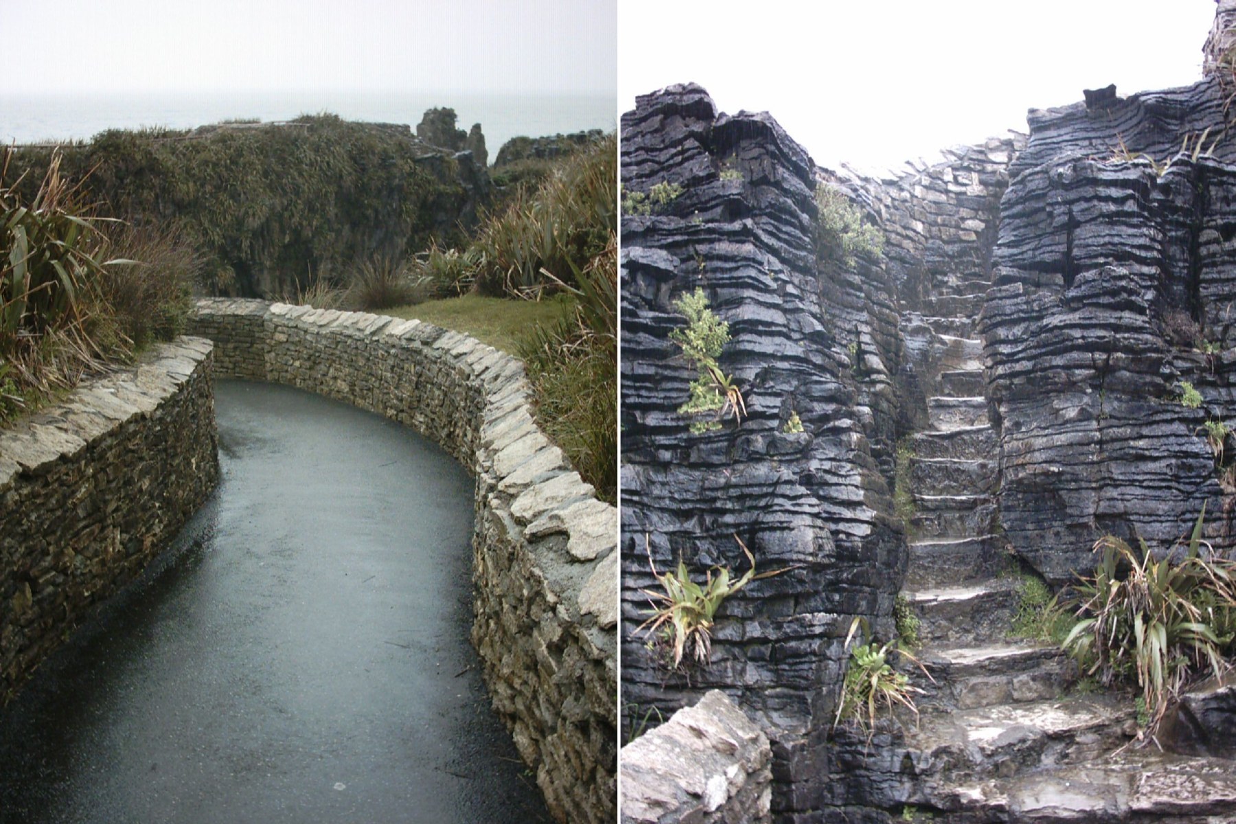
Walking the Edge
The Pancake Rocks sit within Paparoa National Park, immediately adjacent to the village of Punakaiki, and a network of walkways threads through and around the formations. Parts of the path are wheelchair-accessible; other sections descend carved stairways into the rock faces, bringing visitors close enough to feel the spray from the blowholes. The formations have been called the most photographed rock feature in New Zealand, and on busy days the walkways fill with visitors timing their arrival to catch high tide, when the blowholes are at their most dramatic. Looking south from Dolomite Point, the coastline stretches toward Greymouth, the limestone giving way to darker rock and dense bush that clings to the coastal hills. The Tasman Sea, grey-green and restless, works against the shore with the same patient erosion that shaped these rocks. It is a landscape defined by the conversation between stone and water, one that has been going on for 30 million years and shows no sign of resolving.
From the Air
Located at 42.117°S, 171.327°E on the West Coast of New Zealand's South Island. The Pancake Rocks sit at Dolomite Point, a prominent limestone headland visible along the coastal strip between Greymouth and Westport. From altitude, look for the pale limestone formations contrasting against the dark bush-covered hills of Paparoa National Park. The nearest airports are Greymouth (NZGM) approximately 45 km south and Westport (NZWS) approximately 55 km north. The coastal strip is narrow here, backed by the Paparoa Range. Best viewed at 2,000-4,000 ft following the coast along State Highway 6. Weather on this coast is notoriously wet, with orographic rainfall from the prevailing westerlies.