Pando Department
The capital of Bolivia's most isolated department carries the name of a ghost. Cobija, the smallest of all Bolivian departmental capitals, was named after the country's former Pacific port -- a harbor lost to Chile in the War of the Pacific over a century ago. That the people of Pando chose to name their new city after a place they could never return to says something about the stubbornness of memory on this frontier, where the Amazon rainforest presses against every road, every clearing, every attempt at permanence.
Territory Won and Lost
Pando exists because of what Bolivia lost elsewhere. The department was organized at the beginning of the twentieth century from the remnants of the Acre Territory, a vast rubber-rich region that Brazil seized in the Acre War of 1903. What remained became Pando, named after President Jose Manuel Pando, who governed from 1899 to 1905 during the bitter conflict. The department sits at the triple junction where Bolivia, Brazil, and Peru converge, covering 63,827 square kilometers of lowland rainforest at an altitude of just 280 meters above sea level. It is the least populous department in Bolivia, with only 130,761 inhabitants recorded in the 2024 census, and the most tropical -- lying closer to the equator than any other Bolivian territory, deep in the Amazonian basin.
The Rubber That Built and Broke a Frontier
In the late nineteenth century, the world's hunger for rubber drew fortune-seekers into Pando's forests. Tappers carved paths through the jungle, scoring the bark of wild Hevea trees and collecting the milky latex that would be smoked into crude rubber balls. For a few decades, this remote corner of Bolivia connected to global industry -- its navigable waterways leading downriver to the Amazon and onward to the Atlantic. But the boom carried the seeds of its own collapse. British agents had smuggled rubber seeds out of Brazil to establish plantations in Southeast Asia, where cultivated rubber proved cheaper and more reliable. When synthetic rubber arrived on top of that, Pando's forest economy crumbled. The tappers did not vanish, though. Many stayed, shifting to Brazil nuts, timber, and cattle -- the economic pillars that sustain the department today.
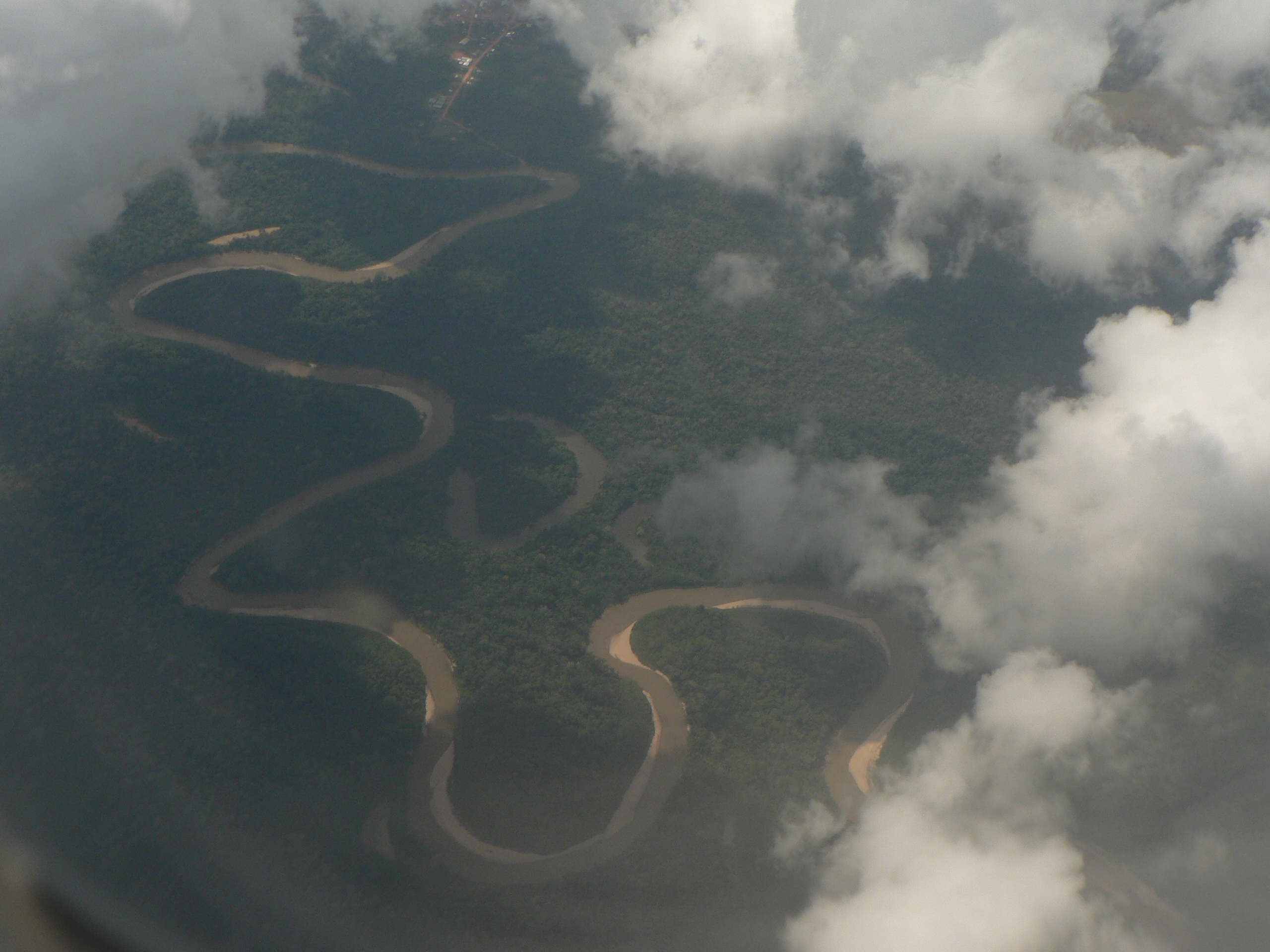
Where the Rain Never Stops
Pando occupies the rainiest corner of Bolivia. Temperatures routinely exceed 26 degrees Celsius, and the wet season transforms the landscape into a labyrinth of flooded forest and swollen rivers. The Tahuamanu, Madre de Dios, and Abuná rivers twist through the canopy in the kind of extravagant meanders that are visible from the air -- great loops of brown water curling back on themselves through unbroken green. The forest harbors jaguars, and the Brazil nut trees that tower above the canopy produce their heavy, coconut-sized seed pods on a cycle that depends on specific orchid bees for pollination. No roads effectively connect Pando to the rest of Bolivia; the department's isolation is not just geographic but infrastructural, a gap that has kept its poverty rates high even as its natural resources remain immense.
The Camba Frontier
Pandinos identify with the Camba culture of Bolivia's tropical lowlands, a cultural identity shared with the neighboring departments of Beni and Santa Cruz. Many of Pando's original settlers migrated from Beni, bringing with them the customs, dialect, and independence of spirit that distinguish the lowlanders from the highland Andean populations who dominate Bolivian politics. This cultural divide erupted into crisis in 2008, when Pando joined the eastern departments' push for greater autonomy from the central government of President Evo Morales. A referendum on June 1, 2008, won 82 percent approval, though nearly half the electorate abstained. The tensions culminated violently in September 2008 with the Porvenir Massacre, in which anti-autonomy supporters of Morales were killed. Prefect Leopoldo Fernandez was arrested for his alleged role, and the central government reasserted control over the department.
A Wilderness Between Nations
Flying over Pando reveals a landscape that defies easy categorization. The forest canopy extends to every horizon, broken only by the silver threads of rivers and the occasional clearing around a settlement. Cobija huddles on the Brazilian border, closer to the Brazilian city of Brasileia than to any major Bolivian population center. The Manuripi-Heath Amazonian Wildlife National Reserve protects a vast tract of the department's southern forests, while the rivers remain the primary highways for communities that roads have never reached. Five provinces -- Abuna, Federico Roman, Madre de Dios, Manuripi, and Nicolas Suarez -- subdivide this territory, but the true divisions are between river and forest, wet season and dry, and the endless tension between a land rich in resources and a population that remains among Bolivia's poorest.
From the Air
Located at 11.18S, 67.18W at 280 meters elevation in northwestern Bolivia. The department is entirely covered by dense Amazonian rainforest with dramatic river meanders visible from altitude. The capital Cobija sits on the Brazilian border. Nearest airport: Capitan Anibal Arab Airport (SLCO) at Cobija. The Tahuamanu and Madre de Dios rivers provide excellent visual navigation references. Best viewed at 5,000-15,000 feet AGL to appreciate the scale of unbroken forest and river systems. Visibility often reduced by tropical rain and humidity.