Paracas National Reserve
The wind here has a name. Locals call it the paracas -- a fierce, sand-laden gust that tears across the Ica coast with enough force to reshape dunes and strip paint from cars. The Paracas National Reserve, Peru's first marine-coastal protected area, exists at the collision point between one of the driest deserts on Earth and one of the most productive oceans. The cold Humboldt Current wells up along this shore, feeding a food chain that supports 216 species of birds, 36 mammals including humpback whales and South American sea lions, and 168 species of fish. Below the sand lie more than 100 archaeological sites left by the Paracas culture, a civilization remembered above all for textiles so intricate they still astonish conservators two thousand years later.
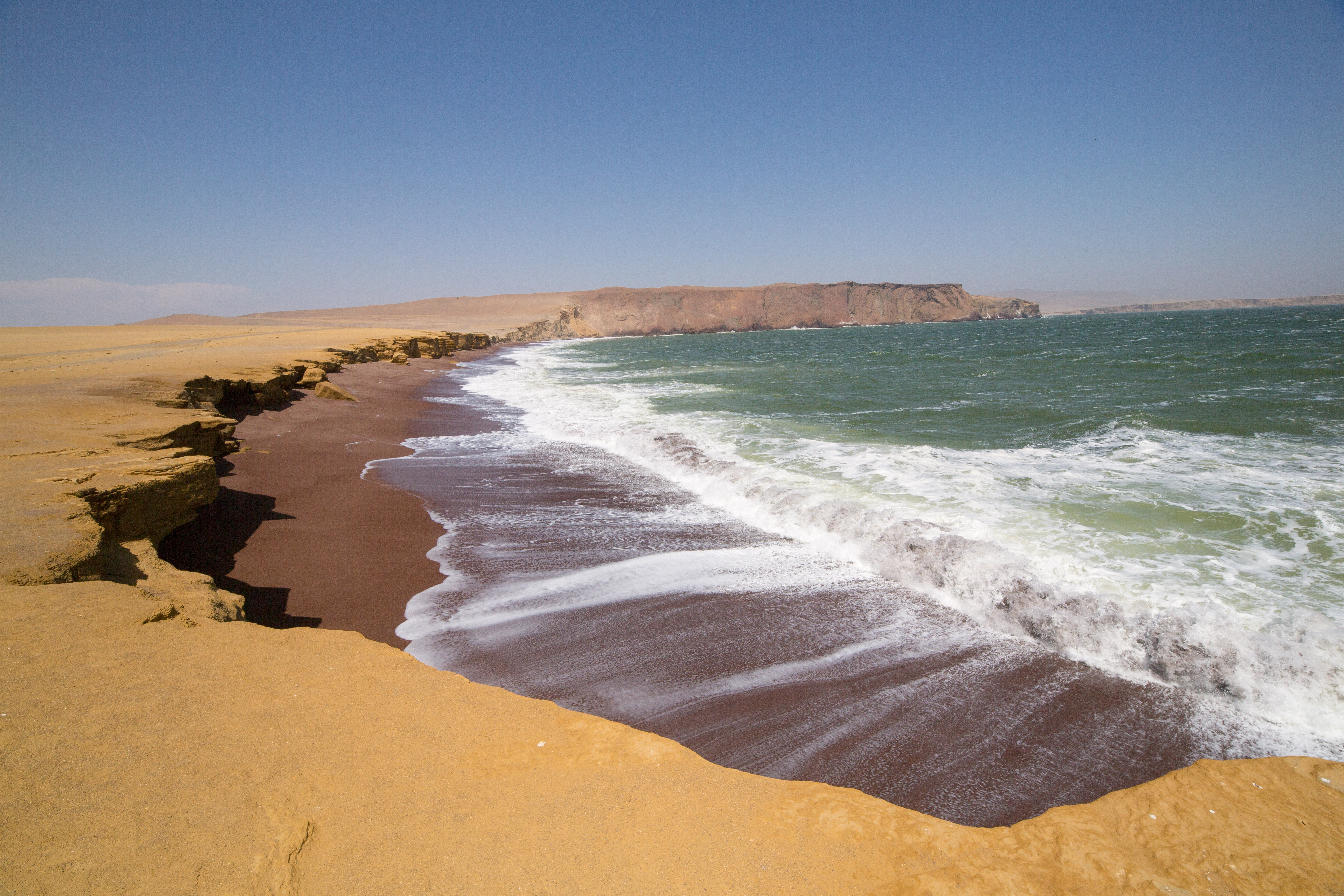
Desert Carved by Sea and Wind
The reserve covers a stark peninsula jutting into the Pacific south of the port town of Pisco. Its highest point reaches only 786 meters, but the terrain feels more dramatic than that modest elevation suggests. Red sandstone cliffs plunge into turquoise water. Beaches shift from ochre to rust to a vivid crimson at Playa Roja, where iron-oxide-rich granules tint the sand the color of dried blood. Until August 2007, the reserve's most iconic formation was La Catedral, a natural rock arch carved by millennia of wave action into the shape of a gothic nave. The 2007 Pisco earthquake collapsed it in seconds. Photographs from before and after -- the arch intact in January 2007, rubble by September -- became a quiet emblem of how quickly the coast reshapes itself.
Where the Cold Water Rises
The Humboldt Current drives everything. Cold, nutrient-rich water surges up from the deep along Peru's southern coast, feeding enormous blooms of phytoplankton that anchor one of the most productive marine food webs on the planet. Peruvian anchoveta swarm in uncountable schools. Skipjack tuna, blue sharks, and Peruvian hake follow them. Above the water, the birds arrive: Humboldt penguins, Chilean flamingos, Peruvian boobies, and Inca terns crowd the rocky islets just offshore. South American fur seals haul out on wave-washed ledges, and marine otters -- among the rarest otters in the world -- hunt in the kelp. Offshore, the deeper waters host sei whales, sperm whales, humpback whales, and pods of dusky dolphins. For a stretch of coast that looks barren from the air, the density of life is staggering.
Threads from Two Thousand Years Ago
The Paracas culture flourished on this peninsula from roughly 800 BCE to 100 BCE, and they left traces everywhere. More than 100 archaeological sites have been identified within the reserve's boundaries. The civilization is best known for its textiles -- elaborately embroidered mantles found wrapping mummified remains in the Paracas Necropolis. The weaving is extraordinarily fine, with as many as 200 threads per inch in some pieces, depicting supernatural beings, animals, and geometric patterns in vivid dyes that have barely faded. These textiles are now scattered across museums worldwide, but the sites where they were found remain here, in the sand and wind of the peninsula. The name paracas itself comes from a Quechua word meaning "sand falling like rain" -- an apt description of what the wind does to anyone standing on these exposed bluffs.
Fragile Ground
Designated in 1975 and recognized as a Ramsar wetland site, the reserve faces the tension common to protected areas that also attract tourists. Beach tourism and wildlife observation are the primary draws, bringing visitors who arrive by bus from Lima or Ica to ride boats past sea lion colonies and walk the red beaches. The 2007 earthquake that destroyed La Catedral also damaged infrastructure throughout the reserve. Climate variability, overfishing in adjacent waters, and the pressure of growing tourism all test the reserve's management. Yet the Humboldt Current keeps pumping nutrients up from the deep, the winds keep scouring the sand, and the ecosystem persists -- as it has since long before the Paracas people wrapped their dead in the finest textiles the ancient Americas ever produced.
From the Air
Located at 14.10S, 76.20W on a peninsula south of Pisco, Peru. The reserve's dramatic red and ochre coastline is visible from 5,000-8,000 feet AGL, with Playa Roja's distinctive crimson sand standing out against the surrounding desert. The Paracas Peninsula extends clearly into the Pacific. Nearest airport: Pisco / Capitan FAP Renán Elías Olivera Airport (SPSO), approximately 15 km north. Lima's Jorge Chávez International Airport (SPJC) is about 250 km to the northwest. The Ballestas Islands, a popular wildlife-viewing destination, are visible offshore to the west.