Park Fire
At 2:44 p.m. on July 24, 2024, two 911 callers reported a car ablaze in Upper Bidwell Park near Chico. Within twelve hours, the fire was consuming 2,500 acres per hour, racing north through the Ishi Wilderness toward Lassen National Forest. By the time firefighters contained the Park Fire on September 26, it had burned over 429,000 acres, becoming the fourth largest wildfire in California history, the second largest single-ignition fire, and the largest ever caused by arson. The cost of suppression alone reached $351 million.
A Landscape Primed to Burn
July 2024 was California's hottest month ever recorded. A nearly two-week heatwave baked the interior of the state, with Chico exceeding 100 degrees Fahrenheit on most days. Evaporative demand, the atmosphere's capability to draw water from vegetation, spiked across the Central Valley, turning the foothills into a tinderbox. Butte County had already endured the Camp Fire in 2018, the North Complex Fire in 2020, and the Dixie Fire in 2021. A New York Times analysis calculated that 38 percent of Butte County and 40 percent of Tehama County had burned in wildfires between 2014 and 2024, an area four to five times larger than in the previous decade. The land was exhausted, parched, and waiting.
How It Started
Shortly before 3:00 p.m. on July 24, 42-year-old Chico resident Ronnie Dean Stout II drove his mother's 2007 Toyota Yaris into Upper Bidwell Park. The car went over a berm and became stuck in dry grass. When Stout revved the engine to free the vehicle, the heat from the catalytic converter ignited the grass beneath, then the car itself. California Highway Patrol investigators later found the car in neutral. Stout fled, blending in with others escaping the growing fire. Cal Fire investigators arrested him at his Chico mobile home at 1:30 a.m. the following morning. He was charged with reckless arson and held without bail.
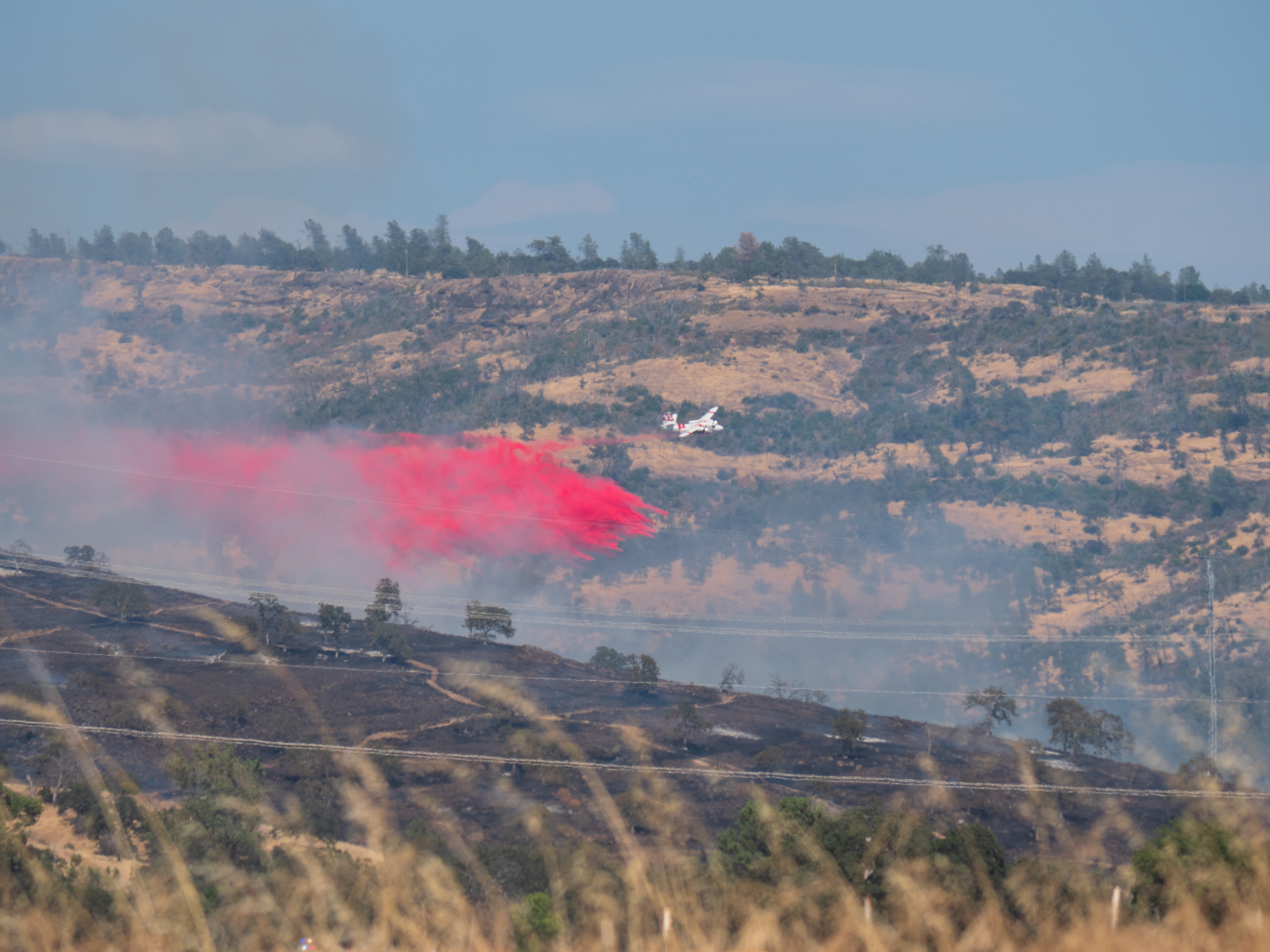
The Explosive Run
Wind-driven flames spread north at terrifying speed, parallel to California State Route 99. Air tankers could not make water drops during the initial fight because high-voltage power lines crisscrossed the fire's path. By 10:15 p.m. on the first day, the fire had consumed over 13,000 acres. It established itself in the Ishi Wilderness, an area with heavy vegetation, little wildfire history, and few access routes for ground crews. By Friday morning, the Park Fire had burned over 45,000 acres with zero percent containment. Less than 72 hours after ignition, the fire surpassed 125,000 acres. Evacuation orders went out for Forest Ranch, Cohasset, northeastern Chico, and Shingletown.
The Human Cost
The fire destroyed 709 structures and damaged 54 others. The McCarthy Point Lookout, a fire lookout post built in 1936 overlooking Mill Creek Canyon, was lost. Pacific Gas & Electric lost 450 power poles, mostly near Cohasset and Forest Ranch, leaving 3,000 customers without electricity. Lassen Volcanic National Park closed to the public on July 27, evacuating visitors from campgrounds and canceling reservations. The North Valley Animal Disaster Group sheltered pets and livestock from evacuated families. Three firefighters sustained heat-related injuries. Smoke drifting east triggered an air quality emergency in Reno, Nevada.
The Ecological Aftermath
Environmental scientists fear lasting damage to endangered spring-run Chinook salmon in Tehama County's Mill Creek and Deer Creek watersheds. Fire retardant used in suppression is toxic to fish, and post-fire rains can wash sediment and debris into streams, causing algal blooms and suffocation. A similar event devastated the Klamath River after the 2022 McKinney Fire. Not all effects were harmful. The fire triggered an unexpected second bloom of native milkweed at the Big Chico Creek Ecological Reserve. Rain arrived on August 23-24, and by August 24, one month after ignition, firefighters observed no active flames for the first time. Full containment came on September 26, 2024.
From the Air
The Park Fire burn scar is centered at approximately 39.778N, 121.761W, stretching from Upper Bidwell Park in Chico north through the Ishi Wilderness and into Tehama County toward Lassen Volcanic National Park. At altitude, the burned area remains starkly visible, a massive brown and gray scar against the surrounding green foothills. Nearby airports include Chico Municipal Airport (KCIC) to the southwest and Redding Municipal Airport (KRDD) to the north. The scar extends roughly 35 miles north-south and 20 miles east-west. Best viewed at 5,000-10,000 feet AGL for full scope.