Parque Nacional de las Cavernas del Río Camuy
Somewhere beneath the sugarcane fields and limestone hills of northwestern Puerto Rico, the Río Camuy disappears. The river drops underground and carves through the karst for more than ten miles, hollowing out chambers tall enough to swallow cathedrals and sinkholes wide enough to straddle three towns. The Taíno knew these caves centuries before anyone thought to call them "discovered" in 1958 -- archaeological evidence confirms that Puerto Rico's first inhabitants explored this darkness long ago, leaving traces that modern spelunkers now find alongside the bats and the blind creatures that have made the perpetual dark their home.
A River That Swallows the World
The Río Camuy is the third-largest subterranean river on Earth, and the cave system it has carved is staggering in scale. Over 220 caves and 16 entrances have been mapped so far, stretching across more than ten miles of underground passages. But experts believe this is only a fraction of the whole -- perhaps another 800 caves remain unexplored, sealed behind collapses and flooded passages that even experienced spelunkers cannot reach. The system lies between the municipalities of Camuy, Hatillo, and Lares, and the 268-acre national park built around its most accessible features is one of Puerto Rico's most popular natural attractions. The park caps daily visits at 1,500 -- a small measure of how much demand this subterranean world generates.
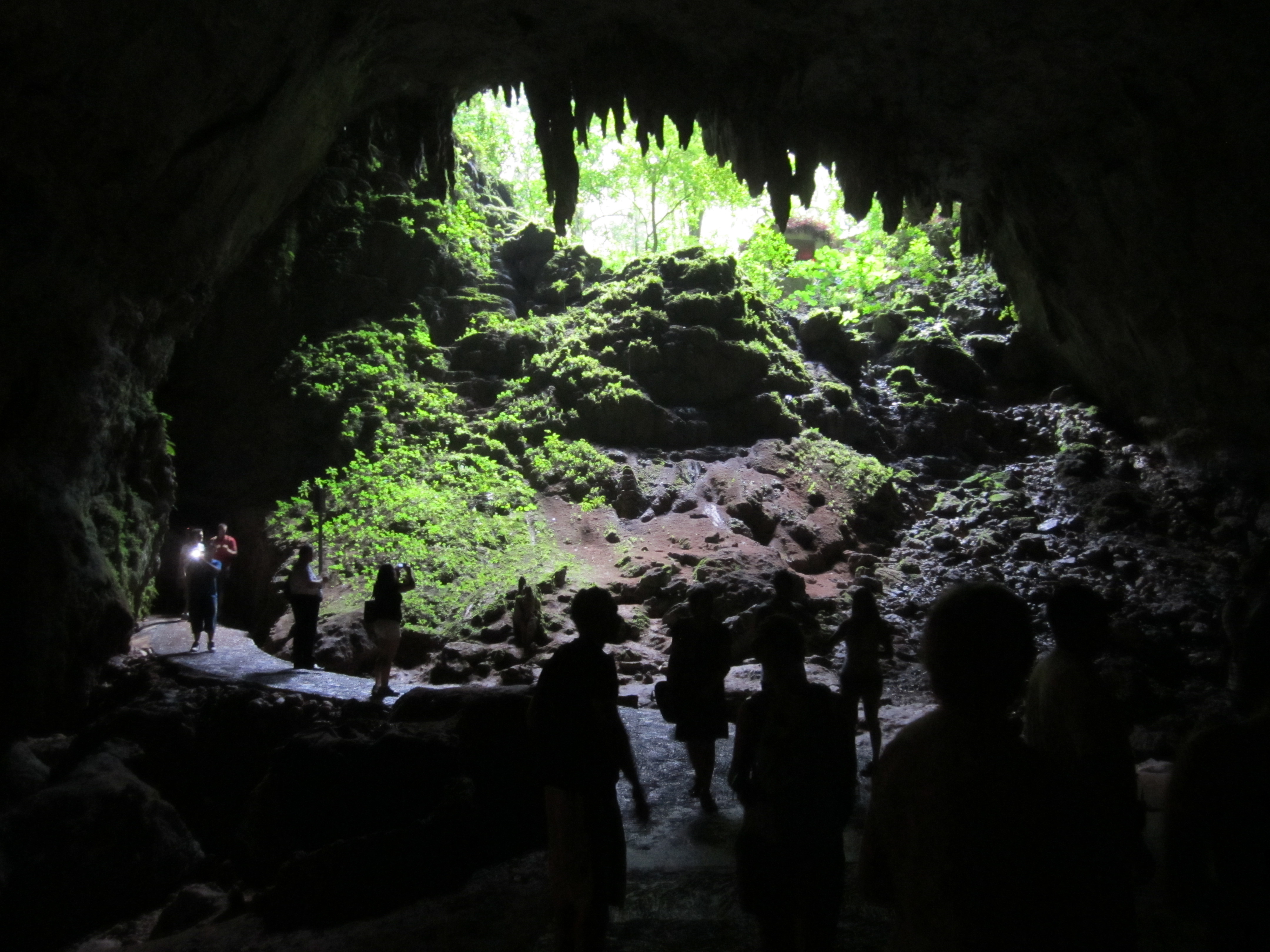
Into the Chamber of Clara
The main attraction is Cueva Clara de Empalme, a single enormous chamber opened to the public in 1986. A short film in the park's 90-seat theater explains the system and its safety rules before a small train carries visitors into the cave's entrance. Inside, the scale hits immediately: the chamber stretches 700 feet long and rises 215 feet high, a space that dwarfs everything visitors thought they knew about caves. From within, they can peer up through a natural opening in the roof to the Sumidero de Empalme sinkhole, 60 meters above -- a window to the sky framed by stalactites, stalagmites, and the restless flutter of thousands of bats. Since 2010, weekly night tours called ECO NIGHTS have offered a different sensory experience entirely, trading daylight glimpses for the sounds and shadows of the cave after dark.
Where Three Towns Meet
The Sumidero Tres Pueblos is the park's most dramatic geological feature: a sinkhole measuring 650 feet across, with the Camuy River visible 400 feet below. The name comes from its location at the exact point where the municipal borders of Camuy, Hatillo, and Lares converge -- each town has built its own observation platform overlooking the crater. Standing at any of these viewpoints, visitors look down into what was once a massive cavern whose roof collapsed thousands of years ago, exposing the river's patient work to open sky. Nearby, a 205-step boardwalk descends into the Sumidero de Espiral, where the cave mouth is off-limits to all but permitted spelunkers who enter with the approval of Puerto Rico's National Parks Company.
Life in Perpetual Darkness
More than 13 species of bats call these caves home, along with hundreds of species of insects, arachnids, and frogs adapted to the unique environment of total darkness and constant humidity. The ecosystem is as fragile as it is remarkable. Hurricane Maria in 2017 forced the park to close for extensive restorations, and it did not reopen until March 2021. Hurricane Fiona then shuttered it again from September 2022 to February 2023. Each closure was a reminder that the caves themselves are ancient and enduring, but the human infrastructure that makes them accessible is not. The storms that batter Puerto Rico above ground send floodwaters surging through the underground channels, reshaping passages and reminding everyone that the Río Camuy is still actively carving its domain.
The Darkness Below the Flight Path
From the air, the karst landscape of northwestern Puerto Rico is unmistakable -- a rumpled green terrain pocked with sinkholes and mogotes, the rounded limestone hills that mark cave country. The Sumidero Tres Pueblos is visible as a dark eye in the green, a hole in the earth that hints at the scale below. But what the aerial view cannot convey is the sound: the echo of the river deep underground, the rustle of bat wings in chambers no sunlight has touched in millennia, the drip of water still dissolving limestone grain by grain. The Taíno heard it. The Gurnees, who first documented the system in their 1973 book Discovery at the Río Camuy, heard it too. The river is still speaking.
From the Air
Located at 18.33°N, 66.84°W in northwestern Puerto Rico, between the municipalities of Camuy, Hatillo, and Lares. The karst landscape with its distinctive mogotes and sinkholes is visible from 3,000-5,000 feet. The Sumidero Tres Pueblos sinkhole (650 ft wide) may be visible as a dark depression in the green terrain. Nearest airport: Rafael Hernandez Airport (TJBQ) in Aguadilla, approximately 20 miles west. Also accessible from Fernando Luis Ribas Dominicci Airport (TJIG) in San Juan. Watch for typical Caribbean afternoon convective weather.